


<< Our Photo Pages >> Garrywhin Fort - Hillfort in Scotland in Caithness
Submitted by h_fenton on Tuesday, 06 December 2011 Page Views: 5845
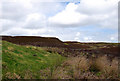
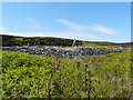
Iron Age and Later PrehistorySite Name: Garrywhin FortCountry: Scotland County: Caithness Type: Hillfort
Nearest Town: Wick Nearest Village: Ulbster
Map Ref: ND3125341377
Latitude: 58.355460N Longitude: 3.176416W
Condition:
| 5 | Perfect |
| 4 | Almost Perfect |
| 3 | Reasonable but with some damage |
| 2 | Ruined but still recognisable as an ancient site |
| 1 | Pretty much destroyed, possibly visible as crop marks |
| 0 | No data. |
| -1 | Completely destroyed |
| 5 | Superb |
| 4 | Good |
| 3 | Ordinary |
| 2 | Not Good |
| 1 | Awful |
| 0 | No data. |
| 5 | Can be driven to, probably with disabled access |
| 4 | Short walk on a footpath |
| 3 | Requiring a bit more of a walk |
| 2 | A long walk |
| 1 | In the middle of nowhere, a nightmare to find |
| 0 | No data. |
| 5 | co-ordinates taken by GPS or official recorded co-ordinates |
| 4 | co-ordinates scaled from a detailed map |
| 3 | co-ordinates scaled from a bad map |
| 2 | co-ordinates of the nearest village |
| 1 | co-ordinates of the nearest town |
| 0 | no data |
Internal Links:
External Links:
I have visited· I would like to visit
SandyG visited on 9th Aug 2014 - their rating: Cond: 4 Amb: 5 Access: 3
h_fenton have visited here
")
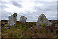
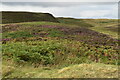
The northern entrance is the most impressive, here the rampart widens to almost 6metres and the entrance passage is defined by three large stones (although there would probably originally been a forth). The stones range from 1.06-1.60metres high.
For further information see: Canmore ID 9034, which contains detailed notes, including a field visit from 1955 and a more recent report from 2004.
The Northern Antiquarian (TNA) also features a page for this site - see their entry for Garrywhin Fort, Ulbster, Caithness, which gives details for getting to the site together with a brief archaeology & history and local folklore.
Note: See also new aerial views of Garrywhin Multiple Stone Rows in the nearby sites list
You may be viewing yesterday's version of this page. To see the most up to date information please register for a free account.
")
")
")
")
Do not use the above information on other web sites or publications without permission of the contributor.
Nearby Images from Geograph Britain and Ireland:
©2011(licence)
©2011(licence)
©2009(licence)
©2022(licence)
©2022(licence)
The above images may not be of the site on this page, they are loaded from Geograph.
Please Submit an Image of this site or go out and take one for us!
Click here to see more info for this site
Nearby sites
Key: Red: member's photo, Blue: 3rd party photo, Yellow: other image, Green: no photo - please go there and take one, Grey: site destroyed
Download sites to:
KML (Google Earth)
GPX (GPS waypoints)
CSV (Garmin/Navman)
CSV (Excel)
To unlock full downloads you need to sign up as a Contributory Member. Otherwise downloads are limited to 50 sites.
Turn off the page maps and other distractions
Nearby sites listing. In the following links * = Image available
155m ESE 123° Garrywhin Multiple Stone Rows* Multiple Stone Rows / Avenue (ND3138241291)
164m SSE 160° Broughwin I* Multiple Stone Rows / Avenue (ND3130741222)
268m SSE 162° Cairn o'Get* Chambered Cairn (ND31334112)
314m SE 125° Watenan Farm* Multiple Stone Rows / Avenue (ND3150941193)
374m S 185° Broughwin IV* Multiple Stone Rows / Avenue (ND3121541004)
411m S 179° Broughwin II* Multiple Stone Rows / Avenue (ND3125440965)
516m ESE 115° Watenan South Broch* Broch or Nuraghe (ND3171641147)
555m E 81° Watenan North Broch Broch or Nuraghe (ND3180441456)
560m SSW 199° Cairn east of Cairn Hanach* Cairn (ND31064085)
569m ESE 120° Loch Watenan* Multiple Stone Rows / Avenue (ND31744108)
584m SSW 205° Cairn Hanach* Chambered Cairn (ND31004085)
596m SSW 194° Broughwin III* Stone Row / Alignment (ND3110040800)
754m SSW 197° Groat’s Loch, South* Stone Row / Alignment (ND3102340658)
805m N 4° Watenan West* Stone Row / Alignment (ND31324218)
809m NE 34° Watenan East* Stone Row / Alignment (ND31724204)
855m E 91° Marquel Stone Row / Alignment (ND32114134)
914m W 260° Warehouse Hill Broch or Nuraghe (ND3034841227)
942m S 179° Clash-an-dam* Stone Row / Alignment (ND3125640434)
977m NW 315° Warehouse South* Chambered Cairn (ND3057342081)
1.0km NW 313° Warehouse West* Cairn (ND3050742107)
1.1km NW 313° Warehouse Standing Stone* Standing Stone (Menhir) (ND3046242147)
1.1km NW 322° Warehouse North* Chambered Cairn (ND3056742276)
1.2km E 83° Ulbster School Broch or Nuraghe (ND3243141497)
1.2km NW 316° Yarrows Fort* Hillfort (ND3041342265)
1.5km ENE 76° Heatherquoy Broch or Nuraghe (ND3271341714)
View more nearby sites and additional images


 We would like to know more about this location. Please feel free to add a brief description and any relevant information in your own language.
 Wir möchten mehr über diese Stätte erfahren. Bitte zögern Sie nicht, eine kurze Beschreibung und relevante Informationen in Deutsch hinzuzufügen.
 Nous aimerions en savoir encore un peu sur les lieux. S'il vous plaît n'hesitez pas à ajouter une courte description et tous les renseignements pertinents dans votre propre langue.
 Quisieramos informarnos un poco más de las lugares. No dude en añadir una breve descripción y otros datos relevantes en su propio idioma.