

<< Our Photo Pages >> South Yarrows Broch - Broch or Nuraghe in Scotland in Caithness
Submitted by howe on Thursday, 11 June 2009 Page Views: 6219
Iron Age and Later PrehistorySite Name: South Yarrows BrochCountry: Scotland County: Caithness Type: Broch or Nuraghe
Nearest Town: Wick Nearest Village: Ulbster
Map Ref: ND3083043492
Latitude: 58.374385N Longitude: 3.184279W
Condition:
| 5 | Perfect |
| 4 | Almost Perfect |
| 3 | Reasonable but with some damage |
| 2 | Ruined but still recognisable as an ancient site |
| 1 | Pretty much destroyed, possibly visible as crop marks |
| 0 | No data. |
| -1 | Completely destroyed |
| 5 | Superb |
| 4 | Good |
| 3 | Ordinary |
| 2 | Not Good |
| 1 | Awful |
| 0 | No data. |
| 5 | Can be driven to, probably with disabled access |
| 4 | Short walk on a footpath |
| 3 | Requiring a bit more of a walk |
| 2 | A long walk |
| 1 | In the middle of nowhere, a nightmare to find |
| 0 | No data. |
| 5 | co-ordinates taken by GPS or official recorded co-ordinates |
| 4 | co-ordinates scaled from a detailed map |
| 3 | co-ordinates scaled from a bad map |
| 2 | co-ordinates of the nearest village |
| 1 | co-ordinates of the nearest town |
| 0 | no data |
Internal Links:
External Links:
I have visited· I would like to visit
markj99 visited on 4th Sep 2021 - their rating: Cond: 3 Amb: 5 Access: 4 While I was travelling back home from John O' Groats, I decided to revisit South Yarrows Archaeological Trail with a fresh eye, having 10 years of antiquarian meanderings under my belt. I found that I understood more details of the sites on my revisit. South Yarrows Archaeological Trail is thoroughly recommended!
SumDoood visited on 17th Aug 2015 - their rating: Cond: 2 Amb: 4 Access: 3 Good one, with a varied history:
http://canmore.org.uk/event/845495
SandyG visited on 10th Aug 2014 - their rating: Cond: 3 Amb: 5 Access: 4
SolarMegalith visited on 20th Jul 2011 - their rating: Cond: 3 Amb: 5 Access: 4
markj99 visited on 6th Jul 2011 - their rating: Cond: 3 Amb: 5 Access: 4 I set off on the South Yarrows Archaeological Trail without any great expectations. I found the walk and variety of the sites a very pleasant surprise.
Richard13 visited on 1st Aug 2007 - their rating: Cond: 3 Amb: 4 Access: 4
SumDoood visited Good one, with a varied history:
http://canmore.org.uk/event/845495
PAB have visited here
Average ratings for this site from all visit loggers: Condition: 2.83 Ambience: 4.67 Access: 3.83
")
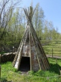
South Yarrows Broch. As part of the South Yarrows Archaeological Trail, this is one of a number of brochs in this area of Caithness.
You may be viewing yesterday's version of this page. To see the most up to date information please register for a free account.
")
")
")
")
")
")
")
")
")
")
")
")
")
")
")
")
")
")
Do not use the above information on other web sites or publications without permission of the contributor.
Click here to see more info for this site
Nearby sites
Key: Red: member's photo, Blue: 3rd party photo, Yellow: other image, Green: no photo - please go there and take one, Grey: site destroyed
Download sites to:
KML (Google Earth)
GPX (GPS waypoints)
CSV (Garmin/Navman)
CSV (Excel)
To unlock full downloads you need to sign up as a Contributory Member. Otherwise downloads are limited to 50 sites.
Turn off the page maps and other distractions
Nearby sites listing. In the following links * = Image available
319m SSE 155° South Yarrows round house* Ancient Village or Settlement (ND30964320)
337m W 264° South Yarrows Chambered Cairn* Chambered Cairn (ND3049343462)
457m SW 228° South Yarrows Long Cairn* Chambered Cairn (ND3048343193)
562m ESE 106° Battle Moss Cairns* Cairn (ND31374333)
701m NE 39° Battle Moss Stone Rows* Multiple Stone Rows / Avenue (ND3128644027)
740m NNE 24° Loch of Yarrows Crannog* Crannog (ND3114944161)
790m E 98° McCole's Castle* Chambered Cairn (ND3161243364)
890m ESE 114° Whiteleen Standing Stones* Standing Stones (ND3163743111)
921m ESE 115° Whiteleen Cairn* Cairn (ND3165743081)
1.2km S 191° Warehouse North* Chambered Cairn (ND3056742276)
1.3km SSW 198° Yarrows Fort* Hillfort (ND3041342265)
1.4km SSW 194° Warehouse Standing Stone* Standing Stone (Menhir) (ND3046242147)
1.4km SSE 159° Watenan West* Stone Row / Alignment (ND31324218)
1.4km SSW 192° Warehouse West* Cairn (ND3050742107)
1.4km S 189° Warehouse South* Chambered Cairn (ND3057342081)
1.5km E 90° Brounaban* Broch or Nuraghe (ND3231243478)
1.7km SSE 148° Watenan East* Stone Row / Alignment (ND31724204)
2.0km E 88° Borrowston Broch* Broch or Nuraghe (ND3288143536)
2.2km SSE 168° Garrywhin Fort* Hillfort (ND3125341377)
2.3km SSE 153° Watenan North Broch Broch or Nuraghe (ND3180441456)
2.3km SSE 165° Garrywhin Multiple Stone Rows* Multiple Stone Rows / Avenue (ND3138241291)
2.3km S 191° Warehouse Hill Broch or Nuraghe (ND3034841227)
2.3km SSE 167° Broughwin I* Multiple Stone Rows / Avenue (ND3130741222)
2.4km SSE 163° Watenan Farm* Multiple Stone Rows / Avenue (ND3150941193)
2.4km SSE 167° Cairn o'Get* Chambered Cairn (ND31334112)
View more nearby sites and additional images


 We would like to know more about this location. Please feel free to add a brief description and any relevant information in your own language.
 Wir möchten mehr über diese Stätte erfahren. Bitte zögern Sie nicht, eine kurze Beschreibung und relevante Informationen in Deutsch hinzuzufügen.
 Nous aimerions en savoir encore un peu sur les lieux. S'il vous plaît n'hesitez pas à ajouter une courte description et tous les renseignements pertinents dans votre propre langue.
 Quisieramos informarnos un poco más de las lugares. No dude en añadir una breve descripción y otros datos relevantes en su propio idioma.