 with our Megalithic Portal iPhone app")

<< Our Photo Pages >> Balm Well - Holy Well or Sacred Spring in Scotland in Midlothian
Submitted by KiwiBetsy on Friday, 08 September 2006 Page Views: 15692
Springs and Holy WellsSite Name: Balm Well Alternative Name: Oily Well, St Catherine’s Well, St Katherine’s Well, Balm Well of St CatherineCountry: Scotland County: Midlothian Type: Holy Well or Sacred Spring
Nearest Town: Edinburgh
Map Ref: NT2732268363
Latitude: 55.902870N Longitude: 3.163969W
Condition:
| 5 | Perfect |
| 4 | Almost Perfect |
| 3 | Reasonable but with some damage |
| 2 | Ruined but still recognisable as an ancient site |
| 1 | Pretty much destroyed, possibly visible as crop marks |
| 0 | No data. |
| -1 | Completely destroyed |
| 5 | Superb |
| 4 | Good |
| 3 | Ordinary |
| 2 | Not Good |
| 1 | Awful |
| 0 | No data. |
| 5 | Can be driven to, probably with disabled access |
| 4 | Short walk on a footpath |
| 3 | Requiring a bit more of a walk |
| 2 | A long walk |
| 1 | In the middle of nowhere, a nightmare to find |
| 0 | No data. |
| 5 | co-ordinates taken by GPS or official recorded co-ordinates |
| 4 | co-ordinates scaled from a detailed map |
| 3 | co-ordinates scaled from a bad map |
| 2 | co-ordinates of the nearest village |
| 1 | co-ordinates of the nearest town |
| 0 | no data |
Internal Links:
External Links:
")
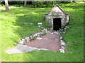
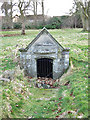
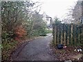
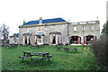
The Balm Well sits in the grounds of the Balmwell Hotel in Howdenhall Road, Edinburgh. Further information can be found at Canmore 152718 which tells us the well takes its name from St. Catherine of Alexandria: "On the surface of the water floats a black tarry substance because of which the well was famous for hundreds of years as a place of cure. This substance is derived from a minute spring exuding from the oil shale below ..... In 1861, the structure was dilapidated, but it was carefully protected in 1889. It is housed within a tiny, modern vaulted structure, which contains a probably unconnected door lintel dated 1563. The inside of the chamber is coated with bituminous matter from the well. Even in 1910, its waters were thought curative for eczema. It is alleged that leprosy was one of the diseases treated at this well. This claim should be discounted. It is based on the erroneous belief that the name of Liberton is a conversion of 'leper-town' and that a leper hospital was situated in the immediate neighbourhood."
You may be viewing yesterday's version of this page. To see the most up to date information please register for a free account.
")
Do not use the above information on other web sites or publications without permission of the contributor.
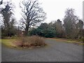
Nearby Images from Geograph Britain and Ireland:
©2011(licence)
©2017(licence)
©2021(licence)
©2021(licence)
©2017(licence)
The above images may not be of the site on this page, they are loaded from Geograph.
Please Submit an Image of this site or go out and take one for us!
Click here to see more info for this site
Nearby sites
Key: Red: member's photo, Blue: 3rd party photo, Yellow: other image, Green: no photo - please go there and take one, Grey: site destroyed
Download sites to:
KML (Google Earth)
GPX (GPS waypoints)
CSV (Garmin/Navman)
CSV (Excel)
To unlock full downloads you need to sign up as a Contributory Member. Otherwise downloads are limited to 50 sites.
Turn off the page maps and other distractions
Nearby sites listing. In the following links * = Image available
2.0km W 267° Galachlaw Cairn* Cairn (NT25366831)
2.3km N 2° Cat Stane (Inch)* Standing Stone (Menhir) (NT27457068)
2.3km NNE 23° Ravenswood Avenue* Standing Stone (Menhir) (NT2828270502)
2.9km W 267° Fairmiliehead (Edinburgh) Cairn (NT24466828)
2.9km W 277° 1, West Camus Road* Modern Stone Circle etc (NT2441068763)
2.9km WNW 286° Buck Stane* Standing Stone (Menhir) (NT24506922)
3.1km W 269° Caiy Stane* Standing Stone (Menhir) (NT2424368357)
3.5km SW 231° Hillend (Loanhead)* Hillfort (NT24526620)
3.5km NNW 343° Penny Well (Edinburgh)* Holy Well or Sacred Spring (NT26367177)
3.6km NW 308° Hanging Stanes (Braid Road)* Marker Stone (NT24517061)
3.8km NE 40° Niddrie House* Standing Stone (Menhir) (NT29877125)
4.1km N 1° Samson's Ribs* Promontory Fort / Cliff Castle (NT27457250)
4.2km WSW 238° Caerketton Hill* Cairn (NT23706621)
4.3km NW 318° The Bore Stone* Marker Stone (NT2450871568)
4.4km N 10° Delf Well* Holy Well or Sacred Spring (NT282727)
4.4km N 352° Slidey Stane (Holyrood Park)* Natural Stone / Erratic / Other Natural Feature (NT2676672765)
4.5km N 3° Arthur's Seat* Hillfort (NT27647282)
4.8km NNW 343° Edinburgh Runestone* Carving (NT2598972937)
4.8km WNW 290° Craiglockart Hill Vitrified Fort Hillfort (NT22827006)
4.9km N 10° Holyrood Park Stone (Edinburgh) Natural Stone / Erratic / Other Natural Feature (NT28267313)
4.9km N 9° Dunsapie Crag* Hillfort (NT28177316)
4.9km N 355° Salisbury Crags* Promontory Fort / Cliff Castle (NT27007326)
5.2km NNW 341° National Museum of Scotland* Museum (NT2574873290)
5.2km NNW 342° National Museum of Scotland (Early Christian Stones)* Ancient Cross (NT2583273324)
5.2km NNW 341° National Museum of Scotland (Pictish Stones)* Museum (NT2572173302)
View more nearby sites and additional images


 We would like to know more about this location. Please feel free to add a brief description and any relevant information in your own language.
 Wir möchten mehr über diese Stätte erfahren. Bitte zögern Sie nicht, eine kurze Beschreibung und relevante Informationen in Deutsch hinzuzufügen.
 Nous aimerions en savoir encore un peu sur les lieux. S'il vous plaît n'hesitez pas à ajouter une courte description et tous les renseignements pertinents dans votre propre langue.
 Quisieramos informarnos un poco más de las lugares. No dude en añadir una breve descripción y otros datos relevantes en su propio idioma.