


<< Our Photo Pages >> Hackland - Standing Stone (Menhir) in Scotland in Orkney
Submitted by howar on Sunday, 22 August 2004 Page Views: 5961
Neolithic and Bronze AgeSite Name: HacklandCountry: Scotland
NOTE: This site is 1.2 km away from the location you searched for.
County: Orkney Type: Standing Stone (Menhir)
Nearest Town: Finstown Nearest Village: Dounby
Map Ref: HY27691936
Latitude: 59.055069N Longitude: 3.262373W
Condition:
| 5 | Perfect |
| 4 | Almost Perfect |
| 3 | Reasonable but with some damage |
| 2 | Ruined but still recognisable as an ancient site |
| 1 | Pretty much destroyed, possibly visible as crop marks |
| 0 | No data. |
| -1 | Completely destroyed |
| 5 | Superb |
| 4 | Good |
| 3 | Ordinary |
| 2 | Not Good |
| 1 | Awful |
| 0 | No data. |
| 5 | Can be driven to, probably with disabled access |
| 4 | Short walk on a footpath |
| 3 | Requiring a bit more of a walk |
| 2 | A long walk |
| 1 | In the middle of nowhere, a nightmare to find |
| 0 | No data. |
| 5 | co-ordinates taken by GPS or official recorded co-ordinates |
| 4 | co-ordinates scaled from a detailed map |
| 3 | co-ordinates scaled from a bad map |
| 2 | co-ordinates of the nearest village |
| 1 | co-ordinates of the nearest town |
| 0 | no data |
Internal Links:
External Links:
")
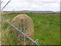
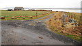
Taking the B9057 west out of Dounby I found down at Hackland a solitary stone in the field alongside the road, no nearby quarries or outcrops or structures to explain its presence.
The stone is 1.1m long by 0.5m high by 0.6m wide, one end manages not to be quite square and the other is simply irregular.
You may be viewing yesterday's version of this page. To see the most up to date information please register for a free account.
Do not use the above information on other web sites or publications without permission of the contributor.
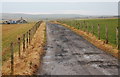
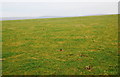
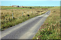
Nearby Images from Geograph Britain and Ireland:
©2009(licence)
©2009(licence)
©2019(licence)
©2007(licence)
©2009(licence)
The above images may not be of the site on this page, they are loaded from Geograph.
Please Submit an Image of this site or go out and take one for us!
Click here to see more info for this site
Nearby sites
Key: Red: member's photo, Blue: 3rd party photo, Yellow: other image, Green: no photo - please go there and take one, Grey: site destroyed
Download sites to:
KML (Google Earth)
GPX (GPS waypoints)
CSV (Garmin/Navman)
CSV (Excel)
To unlock full downloads you need to sign up as a Contributory Member. Otherwise downloads are limited to 50 sites.
Turn off the page maps and other distractions
Nearby sites listing. In the following links * = Image available
1.2km E 79° Hourston* Crannog (HY28891957)
2.2km ESE 116° Burrian (Russland)* Broch or Nuraghe (HY29641835)
2.6km NNW 333° Knowes of Howana Barrow Cemetery (HY26542169)
2.7km E 87° Laxhowe* Artificial Mound (HY30361943)
2.8km SW 232° Hurkisgarth* Round Barrow(s) (HY25451770)
2.9km E 92° Knowe of Browsky* Artificial Mound (HY306192)
2.9km ENE 71° Holodyke Cairn (HY30482028)
2.9km E 94° Foldarol's Hole* Artificial Mound (HY30631909)
3.0km WNW 285° Russel Howe* Cairn (HY24842016)
3.0km NNE 12° Knowe of Taft Broch or Nuraghe (HY28362226)
3.2km ENE 77° North Bigging* Broch or Nuraghe (HY3082420003)
3.3km E 97° Uvigar* Artificial Mound (HY30951888)
3.6km NW 308° Holy Kirk Stones Chambered Cairn (HY249216)
3.8km SSW 208° Via Barrow* Round Barrow(s) (HY25841609)
3.8km SSW 206° Stones of Via* Ancient Village or Settlement (HY260160)
3.8km SSW 205° Via Mound* Round Cairn (HY26011598)
3.9km ESE 111° Overbrough* Broch or Nuraghe (HY31361790)
4.0km E 82° Nisthouse Barrow Cemetery (HY31631983)
4.0km SSW 208° Fiddlerhouse* Standing Stones (HY25771588)
4.0km SE 128° Knowe of Burrian (Garth Farm)* Broch or Nuraghe (HY30821680)
4.1km E 93° Howen Broch Broch or Nuraghe (HY318191)
4.3km S 187° Stackrue-Lyking Mound* Misc. Earthwork (HY27121514)
4.3km SE 134° Knowe of Gullow* Broch or Nuraghe (HY307163)
4.3km S 187° Stackrue* Broch or Nuraghe (HY271151)
4.3km S 188° Burroughston 2* Broch or Nuraghe (HY270151)
View more nearby sites and additional images


 We would like to know more about this location. Please feel free to add a brief description and any relevant information in your own language.
 Wir möchten mehr über diese Stätte erfahren. Bitte zögern Sie nicht, eine kurze Beschreibung und relevante Informationen in Deutsch hinzuzufügen.
 Nous aimerions en savoir encore un peu sur les lieux. S'il vous plaît n'hesitez pas à ajouter une courte description et tous les renseignements pertinents dans votre propre langue.
 Quisieramos informarnos un poco más de las lugares. No dude en añadir una breve descripción y otros datos relevantes en su propio idioma.