


<< Text Pages >> East Lomond Hill - Hillfort in Scotland in Fife
Submitted by Andy B on Friday, 12 August 2016 Page Views: 5731
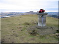
Iron Age and Later PrehistorySite Name: East Lomond HillCountry: Scotland County: Fife Type: Hillfort
Map Ref: NO24400620
Latitude: 56.242292N Longitude: 3.221396W
Condition:
| 5 | Perfect |
| 4 | Almost Perfect |
| 3 | Reasonable but with some damage |
| 2 | Ruined but still recognisable as an ancient site |
| 1 | Pretty much destroyed, possibly visible as crop marks |
| 0 | No data. |
| -1 | Completely destroyed |
| 5 | Superb |
| 4 | Good |
| 3 | Ordinary |
| 2 | Not Good |
| 1 | Awful |
| 0 | No data. |
| 5 | Can be driven to, probably with disabled access |
| 4 | Short walk on a footpath |
| 3 | Requiring a bit more of a walk |
| 2 | A long walk |
| 1 | In the middle of nowhere, a nightmare to find |
| 0 | No data. |
| 5 | co-ordinates taken by GPS or official recorded co-ordinates |
| 4 | co-ordinates scaled from a detailed map |
| 3 | co-ordinates scaled from a bad map |
| 2 | co-ordinates of the nearest village |
| 1 | co-ordinates of the nearest town |
| 0 | no data |
Internal Links:
External Links:
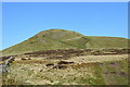
A large and important hill fort on the East Lomond, in the construction of which the lines and character of the defences have been blended into the natural configuration of the hill-top.
The summit enclosure, which is small for the strength of its defences, is 200ft long, NW-SE, by about 100ft average width.
On the N and NE sides, ramparts and terraces have been constructed despite the steepness of the slope. Even stronger works exist on the S comprising an intricate series of rickle-wall defences, a massive rampart of earth and stone and an outside ditch. The wall defences are broken up and scattered; the ditch and rampart has an entrance gap 49ft wide on the SE side.
Source: Canmore
You may be viewing yesterday's version of this page. To see the most up to date information please register for a free account.
Do not use the above information on other web sites or publications without permission of the contributor.
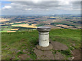
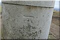
Nearby Images from Geograph Britain and Ireland:
©2017(licence)
©2019(licence)
©2023(licence)
©2023(licence)
©2013(licence)
The above images may not be of the site on this page, they are loaded from Geograph.
Please Submit an Image of this site or go out and take one for us!
Click here to see more info for this site
Nearby sites
Key: Red: member's photo, Blue: 3rd party photo, Yellow: other image, Green: no photo - please go there and take one, Grey: site destroyed
Download sites to:
KML (Google Earth)
GPX (GPS waypoints)
CSV (Garmin/Navman)
CSV (Excel)
To unlock full downloads you need to sign up as a Contributory Member. Otherwise downloads are limited to 50 sites.
Turn off the page maps and other distractions
Nearby sites listing. In the following links * = Image available
1.4km NE 36° Westfield Farm Class I Pictish Symbol Stone (NO25260735)
2.5km WNW 303° Kilgour Class I Pictish Symbol Stone (NO223076)
4.5km NNW 340° Auchtermuchty Cursus Cursus (NO22951043)
4.9km NW 325° Strathmiglo* Class I Pictish Symbol Stone (NO2166810219)
4.9km SE 128° Balfarg Henge* Henge (NO2819803123)
4.9km SSW 195° Strathhendry* Stone Circle (NO23050145)
5.1km SE 126° Balfarg Riding School mortuary enclosure and henge* Henge (NO28480314)
5.3km SE 127° Balbirnie* Stone Circle (NO2858702969)
7.4km SW 231° Scotlandwell* Holy Well or Sacred Spring (NO1847801656)
7.5km SW 236° Kilmagadwood Early Bronze Age cemetery Barrow Cemetery (NO1805702119)
8.5km NNE 33° Newton of Collessie Class I Pictish Symbol Stone (NO292132)
8.5km NE 34° Collessie* Standing Stone (Menhir) (NO293132)
9.4km S 184° Dogton* Class III Pictish Cross Slab (NT2360996863)
9.6km WSW 258° Orwell Standing Stones* Standing Stones (NO14940432)
10.2km N 8° Lindores* Class I Pictish Symbol Stone (NO25951634)
10.6km N 350° Macduff's Cross* Early Christian Sculptured Stone (NO227167)
11.4km NNW 330° Abernethy Den* Stone Circle (NO188161)
11.4km ENE 62° Walton Symbol Stone Class I Pictish Symbol Stone (NO34651135)
11.5km NNW 331° Abernethy Symbol Stone* Class I Pictish Symbol Stone (NO18991638)
11.5km W 259° Orwell Cursus Cursus (NO13010423)
11.6km SE 138° Earlseat* Standing Stone (Menhir) (NT3197797452)
11.6km SSW 208° Hare Law (Fife)* Cairn (NT187961)
11.9km NNW 332° Abernethy Circle Stone Circle (NO189168)
11.9km N 354° Laing's Museum, Newburgh* Museum (NO233181)
12.1km N 350° Mugdrum Class III Pictish Cross Slab (NO22531819)
View more nearby sites and additional images


 We would like to know more about this location. Please feel free to add a brief description and any relevant information in your own language.
 Wir möchten mehr über diese Stätte erfahren. Bitte zögern Sie nicht, eine kurze Beschreibung und relevante Informationen in Deutsch hinzuzufügen.
 Nous aimerions en savoir encore un peu sur les lieux. S'il vous plaît n'hesitez pas à ajouter une courte description et tous les renseignements pertinents dans votre propre langue.
 Quisieramos informarnos un poco más de las lugares. No dude en añadir una breve descripción y otros datos relevantes en su propio idioma.