


<< Our Photo Pages >> Vestrafiold - Ancient Mine, Quarry or other Industry in Scotland in Orkney
Submitted by Andy B on Friday, 04 August 2006 Page Views: 7189
Multi-periodSite Name: Vestrafiold Alternative Name: Vestra FioldCountry: Scotland County: Orkney Type: Ancient Mine, Quarry or other Industry
Nearest Town: Stromness Nearest Village: Sandwick
Map Ref: HY241220
Latitude: 59.078146N Longitude: 3.325855W
Condition:
| 5 | Perfect |
| 4 | Almost Perfect |
| 3 | Reasonable but with some damage |
| 2 | Ruined but still recognisable as an ancient site |
| 1 | Pretty much destroyed, possibly visible as crop marks |
| 0 | No data. |
| -1 | Completely destroyed |
| 5 | Superb |
| 4 | Good |
| 3 | Ordinary |
| 2 | Not Good |
| 1 | Awful |
| 0 | No data. |
| 5 | Can be driven to, probably with disabled access |
| 4 | Short walk on a footpath |
| 3 | Requiring a bit more of a walk |
| 2 | A long walk |
| 1 | In the middle of nowhere, a nightmare to find |
| 0 | No data. |
| 5 | co-ordinates taken by GPS or official recorded co-ordinates |
| 4 | co-ordinates scaled from a detailed map |
| 3 | co-ordinates scaled from a bad map |
| 2 | co-ordinates of the nearest village |
| 1 | co-ordinates of the nearest town |
| 0 | no data |
Be the first person to rate this site - see the 'Contribute!' box in the right hand menu.
Internal Links:
External Links:
I have visited· I would like to visit
ModernExplorers visited on 5th Mar 2013 - their rating: Cond: 2 Amb: 4 Access: 1 Really interesting to have found the site although very difficult to find. Piles of stone in fields that look like they were cut and bits of rock emanating from the ground
")
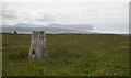
Prone stones can still be seen lying on Vestrafiold's hillside to this day and recent work at the site has confirmed that megaliths were indeed quarried there.
Comparatively little effort would have had to have gone into shaping the stones as the Vestrafiold rock splits easily into slabs.
After being quarried from the hillside, the megaliths were transported the 7.5 miles to the Ness o' Brodgar.
More: Orkneyjar
You may be viewing yesterday's version of this page. To see the most up to date information please register for a free account.
")
")
")
")
Do not use the above information on other web sites or publications without permission of the contributor.
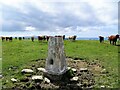
Nearby Images from Geograph Britain and Ireland:
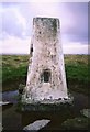
©2010(licence)

©2015(licence)
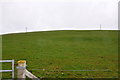
©2009(licence)
©2010(licence)
©2022(licence)
The above images may not be of the site on this page, they are loaded from Geograph.
Please Submit an Image of this site or go out and take one for us!
Click here to see more info for this site
Nearby sites
Key: Red: member's photo, Blue: 3rd party photo, Yellow: other image, Green: no photo - please go there and take one, Grey: site destroyed
Download sites to:
KML (Google Earth)
GPX (GPS waypoints)
CSV (Garmin/Navman)
CSV (Excel)
To unlock full downloads you need to sign up as a Contributory Member. Otherwise downloads are limited to 50 sites.
Turn off the page maps and other distractions
Nearby sites listing. In the following links * = Image available
223m SSW 205° Vestra Fiold Chambered Cairn (HY240218)
892m ESE 115° Holy Kirk Stones Chambered Cairn (HY249216)
1.7km SSW 207° Upper Garson* Standing Stones (HY233205)
2.0km SSE 157° Russel Howe* Cairn (HY24842016)
2.1km SSW 202° Linnahowe* Ancient Village or Settlement (HY233201)
2.4km SSW 203° Knowe of Verron* Broch or Nuraghe (HY231198)
2.5km E 96° Knowes of Howana Barrow Cemetery (HY26542169)
2.9km NNE 27° Spurdagove Standing Stones (HY255246)
3.4km SSW 196° Skara Brae* Ancient Village or Settlement (HY2312518745)
4.0km NE 41° Queenafjold* Barrow Cemetery (HY268250)
4.3km E 85° Knowe of Taft Broch or Nuraghe (HY28362226)
4.3km SSW 196° Knowe of Geoso* Chambered Cairn (HY22821792)
4.4km SE 125° Hackland* Standing Stone (Menhir) (HY27691936)
4.5km NNE 15° Stone 'O Quoybune* Standing Stone (Menhir) (HY25312629)
4.5km SSE 161° Hurkisgarth* Round Barrow(s) (HY25451770)
4.6km S 191° Knowe of Nebigarth* Barrow Cemetery (HY23161750)
4.8km S 186° Knowe of Angerow* Round Barrow(s) (HY235172)
4.9km NNE 14° Oxtro* Broch or Nuraghe (HY25372678)
5.1km NE 50° Loch of Boardhouse* Standing Stone (Menhir) (HY28052520)
5.4km ESE 116° Hourston* Crannog (HY28891957)
5.5km SSW 197° Broch of Borwick* Broch or Nuraghe (HY2241416777)
5.7km S 186° South Seatter Round Barrow(s) (HY23391637)
5.7km NNE 13° Broch of Oxtro Class I Pictish Symbol Stone (HY255275)
5.7km NNE 15° St.Magnus's Well* Holy Well or Sacred Spring (HY25652750)
6.2km SSE 162° Via Barrow* Round Barrow(s) (HY25841609)
View more nearby sites and additional images


 We would like to know more about this location. Please feel free to add a brief description and any relevant information in your own language.
 Wir möchten mehr über diese Stätte erfahren. Bitte zögern Sie nicht, eine kurze Beschreibung und relevante Informationen in Deutsch hinzuzufügen.
 Nous aimerions en savoir encore un peu sur les lieux. S'il vous plaît n'hesitez pas à ajouter une courte description et tous les renseignements pertinents dans votre propre langue.
 Quisieramos informarnos un poco más de las lugares. No dude en añadir una breve descripción y otros datos relevantes en su propio idioma.