 with our Megalithic Portal iPhone app")


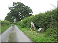
<< Our Photo Pages >> Dyffryn Lane, Berriew - Henge in Wales in Powys
Submitted by PauM on Tuesday, 01 August 2006 Page Views: 9079
Neolithic and Bronze AgeSite Name: Dyffryn Lane, BerriewCountry: Wales County: Powys Type: Henge
Nearest Town: Welshpool Nearest Village: Berriew
Map Ref: SJ2044101409 Landranger Map Number: 126
Latitude: 52.604617N Longitude: 3.176212W
Condition:
| 5 | Perfect |
| 4 | Almost Perfect |
| 3 | Reasonable but with some damage |
| 2 | Ruined but still recognisable as an ancient site |
| 1 | Pretty much destroyed, possibly visible as crop marks |
| 0 | No data. |
| -1 | Completely destroyed |
| 5 | Superb |
| 4 | Good |
| 3 | Ordinary |
| 2 | Not Good |
| 1 | Awful |
| 0 | No data. |
| 5 | Can be driven to, probably with disabled access |
| 4 | Short walk on a footpath |
| 3 | Requiring a bit more of a walk |
| 2 | A long walk |
| 1 | In the middle of nowhere, a nightmare to find |
| 0 | No data. |
| 5 | co-ordinates taken by GPS or official recorded co-ordinates |
| 4 | co-ordinates scaled from a detailed map |
| 3 | co-ordinates scaled from a bad map |
| 2 | co-ordinates of the nearest village |
| 1 | co-ordinates of the nearest town |
| 0 | no data |
Internal Links:
External Links:
I have visited· I would like to visit
TimPrevett has visited here
")
(the CPAT has an aerial image and a topographical survey - scroll down the page on the link).
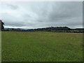
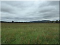
This site is located at a strategic point in the Powys landscape close to the confluence of three river valleys on the low ground. These valleys would have been important passes between the mountain ranges and could well have acted as trade routes therefore making this henge a potentially crucial trading point for the whole of mid-Wales.
For more information see Coflein NPRN 306967.
Note: Dig Open Day this Sunday, see comment
You may be viewing yesterday's version of this page. To see the most up to date information please register for a free account.
")
")
Do not use the above information on other web sites or publications without permission of the contributor.
Nearby Images from Geograph Britain and Ireland:
©2017(licence)
©2017(licence)
©2010(licence)
©2010(licence)
©2012(licence)
The above images may not be of the site on this page, they are loaded from Geograph.
Please Submit an Image of this site or go out and take one for us!
Click here to see more info for this site
Nearby sites
Key: Red: member's photo, Blue: 3rd party photo, Yellow: other image, Green: no photo - please go there and take one, Grey: site destroyed
Download sites to:
KML (Google Earth)
GPX (GPS waypoints)
CSV (Garmin/Navman)
CSV (Excel)
To unlock full downloads you need to sign up as a Contributory Member. Otherwise downloads are limited to 50 sites.
Turn off the page maps and other distractions
Nearby sites listing. In the following links * = Image available
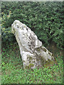
182m SW 234° Maen Beuno* Standing Stone (Menhir) (SJ2029201303)
1.8km WSW 249° St Beuno (Berriew)* Natural Stone / Erratic / Other Natural Feature (SJ18780082)
3.6km NNE 18° Welshpool A Cursus Cursus (SJ21640480)
3.8km NNE 22° Sarn-y-Bryn-Caled* Timber Circle (SJ219049)
3.8km NNE 20° Welshpool A Cursus Cursus (SJ21820497)
3.9km NNE 20° Sarn-y-bryn-caled II Cursus Cursus (SJ21830505)
4.1km NNE 21° Sarn-y-bryn-caled II Cursus Cursus (SJ21970523)
4.7km SSE 164° Ffridd Faldwyn* Hillfort (SO217969)
5.6km ESE 122° Chirbury* Henge (SO25189838)
6.3km NNE 19° Powysland Museum* Museum (SJ226073)
6.3km NNE 21° Welshpool Eisteddfod Circle* Modern Stone Circle etc (SJ2286307263)
6.5km NNE 17° Maen Llog* Standing Stone (Menhir) (SJ225076)
7.5km NE 53° Beacon Ring* Hillfort (SJ265058)
8.8km SE 128° Calcot Camp* Hillfort (SO273959)
8.9km NE 43° Trinity Well, Cletterwood Holy Well or Sacred Spring (SJ26650780)
9.0km SSE 150° The Rossett* Round Barrow(s) (SO24879352)
9.6km ESE 104° Middleton Hall* Standing Stone (Menhir) (SO297989)
10.1km ESE 105° Middleton Hill Round Barrow(s) (SO302987)
10.4km ESE 112° New House Long Barrow* Long Barrow (SO300973)
10.4km ESE 106° Mitchell's Fold* Stone Circle (SO30429837)
10.4km ESE 107° Mitchell's Fold outlier* Standing Stone (Menhir) (SO30429828)
10.5km ENE 65° Walton Camp* Hillfort (SJ301057)
10.6km ESE 107° Druid's Castle* Stone Circle (SO305981)
10.7km ESE 115° Corndon Hill 7* Cairn (SO301968)
10.7km ESE 110° The Whetstones* Stone Circle (SO30429753)
View more nearby sites and additional images


 We would like to know more about this location. Please feel free to add a brief description and any relevant information in your own language.
 Wir möchten mehr über diese Stätte erfahren. Bitte zögern Sie nicht, eine kurze Beschreibung und relevante Informationen in Deutsch hinzuzufügen.
 Nous aimerions en savoir encore un peu sur les lieux. S'il vous plaît n'hesitez pas à ajouter une courte description et tous les renseignements pertinents dans votre propre langue.
 Quisieramos informarnos un poco más de las lugares. No dude en añadir una breve descripción y otros datos relevantes en su propio idioma.