


<< Our Photo Pages >> Llanfihangel Cwmdu - Ancient Cross in Wales in Powys
Submitted by TimPrevett on Saturday, 02 September 2006 Page Views: 9003
Early Medieval (Dark Age)Site Name: Llanfihangel Cwmdu Alternative Name: St Michael's Church (Llanvihangel-Cum-Du)Country: Wales
NOTE: This site is 1.0 km away from the location you searched for.
County: Powys Type: Ancient Cross
Nearest Town: Crickhowell Nearest Village: Cwmdu
Map Ref: SO18052384
Latitude: 51.907046N Longitude: 3.192654W
Condition:
| 5 | Perfect |
| 4 | Almost Perfect |
| 3 | Reasonable but with some damage |
| 2 | Ruined but still recognisable as an ancient site |
| 1 | Pretty much destroyed, possibly visible as crop marks |
| 0 | No data. |
| -1 | Completely destroyed |
| 5 | Superb |
| 4 | Good |
| 3 | Ordinary |
| 2 | Not Good |
| 1 | Awful |
| 0 | No data. |
| 5 | Can be driven to, probably with disabled access |
| 4 | Short walk on a footpath |
| 3 | Requiring a bit more of a walk |
| 2 | A long walk |
| 1 | In the middle of nowhere, a nightmare to find |
| 0 | No data. |
| 5 | co-ordinates taken by GPS or official recorded co-ordinates |
| 4 | co-ordinates scaled from a detailed map |
| 3 | co-ordinates scaled from a bad map |
| 2 | co-ordinates of the nearest village |
| 1 | co-ordinates of the nearest town |
| 0 | no data |
Internal Links:
External Links:
I have visited· I would like to visit
coin visited on 15th Jul 2014 - their rating: Cond: 4 Amb: 3 Access: 5
ieuanparry visited - their rating: Cond: 4 Amb: 4 Access: 5
Average ratings for this site from all visit loggers: Condition: 4 Ambience: 3.5 Access: 5
")
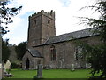
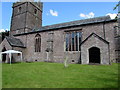
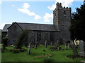
Two carved stones sit in a visible position on the south side of the church. The first reads CATACUS HIC IACIT / FILIUS TERENACUS (Catacus lies here / son of Tegernacus), and is on a central buttress of the church. This is dated to late 6th or early 7th century.
The other lies in a locked porch, with the carved HIC IACIT visible (no name); this is dated 12th to 13th century. An earlier 7th to 9th century cross lies underneath.
A third stone mentioned in Helen Burnham's guidebook to Powys was not visible within the porch.
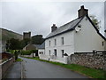
Parking for 2 cars next to church just off A40 near the pub. The rear of the church is wonderfully atmospheric. Access can be gained to the church by following instructions from the notice in the main porch.
The stones are recorded as Coflein NPRN 275612. The Journal of Antiquities also features a entry which includes these stones - scroll down their page for Some Inscribed Stones in Wales. The Journal adds that the stone now built into the buttress on the south wall had been used as a stepping stone over a brookl the other now forms the windowsill in the chancel.
You may be viewing yesterday's version of this page. To see the most up to date information please register for a free account.
")
")
")
")
Do not use the above information on other web sites or publications without permission of the contributor.
Nearby Images from Geograph Britain and Ireland:
©2012(licence)
©2018(licence)
©2018(licence)
©2013(licence)
©2013(licence)
The above images may not be of the site on this page, they are loaded from Geograph.
Please Submit an Image of this site or go out and take one for us!
Click here to see more info for this site
Nearby sites
Key: Red: member's photo, Blue: 3rd party photo, Yellow: other image, Green: no photo - please go there and take one, Grey: site destroyed
Download sites to:
KML (Google Earth)
GPX (GPS waypoints)
CSV (Garmin/Navman)
CSV (Excel)
To unlock full downloads you need to sign up as a Contributory Member. Otherwise downloads are limited to 50 sites.
Turn off the page maps and other distractions
Nearby sites listing. In the following links * = Image available
476m WNW 289° Coed y Gaer Hillfort (SO176240)
682m NW 317° Coed y Gaer Cairn Cairn (SO1759324348)
1.4km W 271° Cwmdu Stone Circle (SO166239)
1.9km S 181° Tretower* Standing Stone (Menhir) (SO180219)
2.1km W 279° Cefn Moel Stone Row / Alignment (SO15932421)
2.2km ESE 106° Pen Gloch Y Pibwr* Cairn (SO2020123205)
2.4km SSW 206° Celtic Head, Middle Gaer Carving (SO16962172)
2.4km W 266° Cefn Moel Round Barrow(s) (SO156237)
2.7km ENE 79° Pen Alltmawr Cairns* Cairn (SO2069024330)
2.7km NNW 326° Mynydd Llangorse 1 Ring Cairn (SO166261)
2.7km NNW 326° Mynydd Llangorse 2 Ring Cairn (SO166261)
2.8km WSW 249° Bwlch Ring Cairn* Ring Cairn (SO154229)
3.2km S 191° Myarth Camp Hillfort (SO174207)
3.5km WSW 237° Bwlch Standing Stone* Standing Stone (Menhir) (SO15052195)
3.7km SE 135° Craig Llwyn* Ancient Village or Settlement (SO206212)
3.9km ESE 111° Pen Cerrig-calch* Cairn (SO21702236)
4.0km S 176° Penmyarth* Standing Stone (Menhir) (SO18291986)
4.2km SW 214° Llwyn-Y-Fedwen* Standing Stone (Menhir) (SO15622039)
4.4km NNW 332° Cockit Hill* Promontory Fort / Cliff Castle (SO16032774)
5.0km NNW 336° Mynydd Troed* Chambered Tomb (SO16142842)
5.1km SW 214° Castle Farm Stone* Standing Stone (Menhir) (SO1507319635)
5.2km N 0° Ty-Isaf* Chambered Tomb (SO18182906)
5.4km W 274° Allt-Yr-Yscrin* Cairn (SO12612435)
5.5km ESE 124° Crug Hywel* Hillfort (SO226207)
5.5km SE 146° Gwernvale* Chambered Tomb (SO2111119217)
View more nearby sites and additional images


 We would like to know more about this location. Please feel free to add a brief description and any relevant information in your own language.
 Wir möchten mehr über diese Stätte erfahren. Bitte zögern Sie nicht, eine kurze Beschreibung und relevante Informationen in Deutsch hinzuzufügen.
 Nous aimerions en savoir encore un peu sur les lieux. S'il vous plaît n'hesitez pas à ajouter une courte description et tous les renseignements pertinents dans votre propre langue.
 Quisieramos informarnos un poco más de las lugares. No dude en añadir una breve descripción y otros datos relevantes en su propio idioma.