


<< Text Pages >> Lacra E - Stone Circle in England in Cumbria
Submitted by theCaptain on Thursday, 15 February 2001 Page Views: 5117
Neolithic and Bronze AgeSite Name: Lacra ECountry: England County: Cumbria Type: Stone Circle
Nearest Town: Millom Nearest Village: Kirksanton
Map Ref: SD15118127 Landranger Map Number: 96
Latitude: 54.220093N Longitude: 3.303424W
Condition:
| 5 | Perfect |
| 4 | Almost Perfect |
| 3 | Reasonable but with some damage |
| 2 | Ruined but still recognisable as an ancient site |
| 1 | Pretty much destroyed, possibly visible as crop marks |
| 0 | No data. |
| -1 | Completely destroyed |
| 5 | Superb |
| 4 | Good |
| 3 | Ordinary |
| 2 | Not Good |
| 1 | Awful |
| 0 | No data. |
| 5 | Can be driven to, probably with disabled access |
| 4 | Short walk on a footpath |
| 3 | Requiring a bit more of a walk |
| 2 | A long walk |
| 1 | In the middle of nowhere, a nightmare to find |
| 0 | No data. |
| 5 | co-ordinates taken by GPS or official recorded co-ordinates |
| 4 | co-ordinates scaled from a detailed map |
| 3 | co-ordinates scaled from a bad map |
| 2 | co-ordinates of the nearest village |
| 1 | co-ordinates of the nearest town |
| 0 | no data |
Internal Links:
External Links:
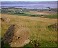
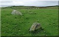
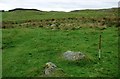
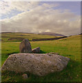
Questionable circle of stones, part of the Lacra complex.
Aubrey Burl in 'A Guide To Stone Circles Of Britain, Ireland and Brittany' states that Lacra E is "a very uncertain ring cairn" that "can be imagined 25ft (8m) to the north-west [of Lacra D]".
Pastscape (under the record for Lacra D) states:
An alleged second circle immediately to the north-west [of Lacra D] comprises three pieces of stone visible at ground level and cannot be certainly identified.
You may be viewing yesterday's version of this page. To see the most up to date information please register for a free account.
Do not use the above information on other web sites or publications without permission of the contributor.
Nearby Images from Geograph Britain and Ireland:
©2013(licence)
©2018(licence)
©2018(licence)
©2013(licence)
©2007(licence)
The above images may not be of the site on this page, they are loaded from Geograph.
Please Submit an Image of this site or go out and take one for us!
Click here to see more info for this site
Nearby sites
Key: Red: member's photo, Blue: 3rd party photo, Yellow: other image, Green: no photo - please go there and take one, Grey: site destroyed
Download sites to:
KML (Google Earth)
GPX (GPS waypoints)
CSV (Garmin/Navman)
CSV (Excel)
To unlock full downloads you need to sign up as a Contributory Member. Otherwise downloads are limited to 50 sites.
Turn off the page maps and other distractions
Nearby sites listing. In the following links * = Image available
41m ESE 103° Lacra Avenue (I)* Multiple Stone Rows / Avenue (SD15158126)
63m SSW 197° Lacra D* Stone Circle (SD15098121)
67m SSW 205° Lacra Avenue (II)* Multiple Stone Rows / Avenue (SD15088121)
114m WNW 284° Lacra* Stone Circle (SD150813)
143m WNW 294° Lacra A.* Stone Circle (SD14988133)
314m SSW 197° Lacra C* Stone Circle (SD1501480971)
343m SSW 212° Lacra B* Stone Circle (SD1492380982)
1.5km W 263° Giants Grave, Kirksanton* Standing Stones (SD1361581103)
1.5km W 266° Kirksanton Stone Circle Stone Circle (SD136812)
4.5km NNW 338° Black Combe* Cairn (SD135855)
5.4km WNW 303° Kirkstones Stone Circle (SD106843)
5.9km NW 318° Hall Foss Stone Circle (SD112857)
6.7km NW 306° Annaside Stone Circle (SD098853)
7.2km NNE 15° Swinside* Stone Circle (SD17168817)
7.3km NNE 34° Ash House* Standing Stones (SD19288729)
7.7km NNW 346° Bootle Fell Round Cairn 2/3* Round Cairn (SD1336388790)
7.9km NNW 348° Bootle Fell Round Cairn 1* Round Cairn (SD1354789043)
7.9km NNW 346° Bootle Fell Round Cairn 4* Round Cairn (SD1333389018)
8.0km NNW 346° Bootle Fell Cairns* Cairn (SD1331989116)
8.6km SE 130° St Helen's Well (Askam and Ireleth) Holy Well or Sacred Spring (SD2161075640)
8.7km ENE 74° Kirkby Hall Holy Well (Kirkby Ireleth) Holy Well or Sacred Spring (SD2357083550)
9.1km NNE 19° Thwaites Fell* Standing Stone (Menhir) (SD1824089813)
9.3km ENE 70° St Mary's Well (Kirkby Ireleth) Holy Well or Sacred Spring (SD2389584270)
9.7km NNE 17° Beckstones and Logan Beck Bridge* Ancient Village or Settlement (SD18069051)
9.8km N 359° Buckbarrow Crag, Hare Raise, Burn Moor and Whitfell Cairn (SD152911)
View more nearby sites and additional images


 We would like to know more about this location. Please feel free to add a brief description and any relevant information in your own language.
 Wir möchten mehr über diese Stätte erfahren. Bitte zögern Sie nicht, eine kurze Beschreibung und relevante Informationen in Deutsch hinzuzufügen.
 Nous aimerions en savoir encore un peu sur les lieux. S'il vous plaît n'hesitez pas à ajouter une courte description et tous les renseignements pertinents dans votre propre langue.
 Quisieramos informarnos un poco más de las lugares. No dude en añadir una breve descripción y otros datos relevantes en su propio idioma.