


<< Text Pages >> Dalmahoy Hill - Hillfort in Scotland in Midlothian
Submitted by Andy B on Monday, 30 March 2009 Page Views: 9334
Iron Age and Later PrehistorySite Name: Dalmahoy HillCountry: Scotland
NOTE: This site is 0.8 km away from the location you searched for.
County: Midlothian Type: Hillfort
Nearest Town: Edinburgh Nearest Village: Balerno
Map Ref: NT135669
Latitude: 55.887442N Longitude: 3.384499W
Condition:
| 5 | Perfect |
| 4 | Almost Perfect |
| 3 | Reasonable but with some damage |
| 2 | Ruined but still recognisable as an ancient site |
| 1 | Pretty much destroyed, possibly visible as crop marks |
| 0 | No data. |
| -1 | Completely destroyed |
| 5 | Superb |
| 4 | Good |
| 3 | Ordinary |
| 2 | Not Good |
| 1 | Awful |
| 0 | No data. |
| 5 | Can be driven to, probably with disabled access |
| 4 | Short walk on a footpath |
| 3 | Requiring a bit more of a walk |
| 2 | A long walk |
| 1 | In the middle of nowhere, a nightmare to find |
| 0 | No data. |
| 5 | co-ordinates taken by GPS or official recorded co-ordinates |
| 4 | co-ordinates scaled from a detailed map |
| 3 | co-ordinates scaled from a bad map |
| 2 | co-ordinates of the nearest village |
| 1 | co-ordinates of the nearest town |
| 0 | no data |
Internal Links:
External Links:
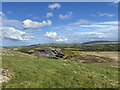
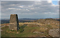
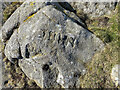
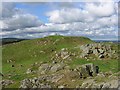
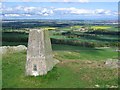
Hillfort in Midlothian. The remains of this fort occupy the twin eminence to that upon which the Kaimes Hill Fort (NT131665) stands. The two forts represent two structural periods, the earlier of which is very difficult to interpret. Briefly, the craggy and uneven hill was enclosed by a system of stone walls which defended and area measuring 1200ft in length by a maximum of about 400 ft in width, bordered on the NW by the precipitous face of the hill.
The second phase structure is an oval enclosure on the very summit of the hill, which measures 140ft by 85ft. This enclosure must occupy the same ground as did the central feature of the fort.
While there is no reason to suppose that the earlier works are not of pre-Roman Iron Age date, the period at which the later enclosure was built has not yet been established. There is reason to believe that it may be of post-Roman date as it belongs to a class of monuments which are almost always found to overlie pre-Roman forts and which have, in some cases, produced relics of early medieval (Dark Age) date.
A gold stud cap 1/5 inch in diameter was picked up in the Dalmahoy secondary enclosure, as were several fragments of moulds, all of which can be assigned to that late period. Only the excavation could answer the problem satisfactorily.
In the area centred NT13436673 are the remains of a hut circle, with an internal diameter of 19ft. There is an inner facing of stones set on edge. The entrance has been from the east.'
Source: RCAHMS
You may be viewing yesterday's version of this page. To see the most up to date information please register for a free account.
Do not use the above information on other web sites or publications without permission of the contributor.
Nearby Images from Geograph Britain and Ireland:
©2022(licence)
©2016(licence)
©2022(licence)
©2008(licence)
©2008(licence)
The above images may not be of the site on this page, they are loaded from Geograph.
Please Submit an Image of this site or go out and take one for us!
Click here to see more info for this site
Nearby sites
Key: Red: member's photo, Blue: 3rd party photo, Yellow: other image, Green: no photo - please go there and take one, Grey: site destroyed
Download sites to:
KML (Google Earth)
GPX (GPS waypoints)
CSV (Garmin/Navman)
CSV (Excel)
To unlock full downloads you need to sign up as a Contributory Member. Otherwise downloads are limited to 50 sites.
Turn off the page maps and other distractions
Nearby sites listing. In the following links * = Image available
639m SW 230° Kaimes Standing Stones (NT130665)
2.1km W 270° Kirknewton stone Sculptured Stone (NT11426693)
2.3km NE 49° Newhouse Standing Stone Standing Stone (Menhir) (NT15296838)
2.8km NNW 347° Tormain Hill* Rock Art (NT12906967)
2.9km NNW 344° Witches' Stone (Ratho)* Rock Art (NT12736973)
4.1km N 354° Witchis Stane* Standing Stone (Menhir) (NT13177104)
4.9km E 79° St Mungo's Well (Edinburgh)* Holy Well or Sacred Spring (NT18346773)
5.5km NNE 20° Gogar Stone* Standing Stone (Menhir) (NT15487199)
5.8km N 351° Lochend menhir* Standing Stone (Menhir) (NT12667263)
5.8km NNW 347° Huly Hill Cairn* Round Cairn (NT1234272610)
5.8km NNW 347° Huly Hill Standing Stones* Standing Stones (NT1234272610)
7.6km N 9° Cat Stane (Kirkliston)* Standing Stone (Menhir) (NT1489374373)
7.7km N 1° Carlowrie (Kirkliston) Rock Art (NT138746)
8.3km NE 46° Physic Well (Corstorphine)* Holy Well or Sacred Spring (NT19597252)
8.3km NE 46° Lady Well* Holy Well or Sacred Spring (NT196726)
8.5km SE 125° Carnethy Hill cairn* Cairn (NT20386192)
8.7km SSE 151° Monks Rig, Font Stone* Ancient Cross (NT17585919)
8.7km NNE 26° Cammo Stone* Standing Stone (Menhir) (NT1747774681)
9.1km SE 141° Camp Hill Burnt Mound South* Artificial Mound (NT19145970)
9.1km SE 141° Camp Hill Burnt Mound North* Artificial Mound (NT19185973)
9.3km SE 140° Braidwood Fort* Hillfort (NT1928059630)
9.8km ENE 70° Craiglockart Hill Vitrified Fort Hillfort (NT22827006)
9.8km ESE 107° Castle Law* Hillfort (NT2290063870)
9.9km ESE 106° Castle Knowe (Glencorse)* Ancient Village or Settlement (NT22996404)
10.2km E 93° Caerketton Hill* Cairn (NT23706621)
View more nearby sites and additional images


 We would like to know more about this location. Please feel free to add a brief description and any relevant information in your own language.
 Wir möchten mehr über diese Stätte erfahren. Bitte zögern Sie nicht, eine kurze Beschreibung und relevante Informationen in Deutsch hinzuzufügen.
 Nous aimerions en savoir encore un peu sur les lieux. S'il vous plaît n'hesitez pas à ajouter une courte description et tous les renseignements pertinents dans votre propre langue.
 Quisieramos informarnos un poco más de las lugares. No dude en añadir una breve descripción y otros datos relevantes en su propio idioma.