


<< Other Photo Pages >> Moncreiffe Hill - Hillfort in Scotland in Perth and Kinross
Submitted by Andy B on Thursday, 24 December 2015 Page Views: 4944
Iron Age and Later PrehistorySite Name: Moncreiffe HillCountry: Scotland County: Perth and Kinross Type: Hillfort
Nearest Town: Perth
Map Ref: NO13131988
Latitude: 56.363231N Longitude: 3.407691W
Condition:
| 5 | Perfect |
| 4 | Almost Perfect |
| 3 | Reasonable but with some damage |
| 2 | Ruined but still recognisable as an ancient site |
| 1 | Pretty much destroyed, possibly visible as crop marks |
| 0 | No data. |
| -1 | Completely destroyed |
| 5 | Superb |
| 4 | Good |
| 3 | Ordinary |
| 2 | Not Good |
| 1 | Awful |
| 0 | No data. |
| 5 | Can be driven to, probably with disabled access |
| 4 | Short walk on a footpath |
| 3 | Requiring a bit more of a walk |
| 2 | A long walk |
| 1 | In the middle of nowhere, a nightmare to find |
| 0 | No data. |
| 5 | co-ordinates taken by GPS or official recorded co-ordinates |
| 4 | co-ordinates scaled from a detailed map |
| 3 | co-ordinates scaled from a bad map |
| 2 | co-ordinates of the nearest village |
| 1 | co-ordinates of the nearest town |
| 0 | no data |
Internal Links:
External Links:
")
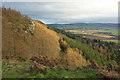
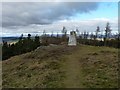
This is Moncreiffe Hillfort, situated at around 175-185m OD on a craggy prominence on the southern side of the hill.
The larger hillfort of Moredun Top will be excavated by the Tay LP team via a series of community excavations in 2015.
Source: AOC Archaology and see the comments below for more details and links
Note: Video: The Hunt for the Hidden Fort – Sophie Nicol presents the results of the excavation at Moncreiffe Hillfort, filmed at the 2015 Tayside and Fife Archaeological Committee Conference. See the most recent comment on our page. Also from the conference, an Early Neolithic settlement, agricultural practice and a Bronze Age barrow found at Dun Knock, also near Perth.
You may be viewing yesterday's version of this page. To see the most up to date information please register for a free account.
")
Do not use the above information on other web sites or publications without permission of the contributor.
Nearby Images from Geograph Britain and Ireland:
©2011(licence)
©2009(licence)
©2011(licence)
©2019(licence)
©2012(licence)
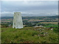
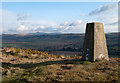
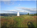
The above images may not be of the site on this page, they are loaded from Geograph.
Please Submit an Image of this site or go out and take one for us!
Click here to see more info for this site
Nearby sites
Key: Red: member's photo, Blue: 3rd party photo, Yellow: other image, Green: no photo - please go there and take one, Grey: site destroyed
Download sites to:
KML (Google Earth)
GPX (GPS waypoints)
CSV (Garmin/Navman)
CSV (Excel)
To unlock full downloads you need to sign up as a Contributory Member. Otherwise downloads are limited to 50 sites.
Turn off the page maps and other distractions
Nearby sites listing. In the following links * = Image available
501m ENE 76° Moredun Top Hillfort (NO13621999)
584m S 172° Moncrieffe Timber Circle (NO132193)
722m SE 138° Moncrieffe* Stone Circle (NO13601933)
762m SE 135° Gask House Class II Pictish Symbol Stone (NO13661933)
762m SE 135° Boar Stone* Class III Pictish Cross Slab (NO13661933)
1.5km NW 309° Craigclowan Standing Stone (Menhir) (NO12022083)
2.2km WNW 290° Hilton Of Moncrieffe* Standing Stone (Menhir) (NO11062067)
2.3km WNW 284° Kirkton Hill Stone Circle (NO109205)
3.1km NNW 337° South Inch, Perth Standing Stone (Menhir) (NO12002274)
3.4km W 281° Callarfountain* Standing Stone (Menhir) (NO09752058)
4.1km NNW 341° Perth Museum and Art Gallery* Museum (NO119238)
4.1km NNW 341° Inchyra* Class I Pictish Symbol Stone (NO119238)
4.3km N 353° Murray Royal Hospital* Standing Stone (Menhir) (NO127242)
6.5km ESE 117° Abernethy Circle Stone Circle (NO189168)
6.6km N 0° Sandy Road East Stone Circle (NO13282646)
6.6km N 0° Sandy Road* Stone Circle (NO1327526463)
6.6km NE 40° Commonbank* Stone Circle (NO1748824837)
6.6km NE 40° Commonbank* Stone Row / Alignment (NO17502484)
6.6km NE 42° Commonbank SE Stone Circle (NO177247)
6.6km E 79° St Madoes Stones* Stone Row / Alignment (NO197210)
6.7km NNE 17° Murrayshall* Standing Stone (Menhir) (NO1519926265)
6.8km ESE 123° Abernethy Den* Stone Circle (NO188161)
6.8km ESE 120° Abernethy Symbol Stone* Class I Pictish Symbol Stone (NO18991638)
7.1km NW 320° Hunting Tower Cursus (NO087254)
7.2km NNE 32° Arnbathie Fort* Hillfort (NO1703125894)
View more nearby sites and additional images


 We would like to know more about this location. Please feel free to add a brief description and any relevant information in your own language.
 Wir möchten mehr über diese Stätte erfahren. Bitte zögern Sie nicht, eine kurze Beschreibung und relevante Informationen in Deutsch hinzuzufügen.
 Nous aimerions en savoir encore un peu sur les lieux. S'il vous plaît n'hesitez pas à ajouter une courte description et tous les renseignements pertinents dans votre propre langue.
 Quisieramos informarnos un poco más de las lugares. No dude en añadir una breve descripción y otros datos relevantes en su propio idioma.