


<< Our Photo Pages >> Taffs Well - Holy Well or Sacred Spring in Wales in South Glamorgan
Submitted by coldrum on Monday, 25 June 2007 Page Views: 11572
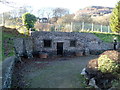
Springs and Holy WellsSite Name: Taffs WellCountry: Wales County: South Glamorgan Type: Holy Well or Sacred Spring
Map Ref: ST1192683638
Latitude: 51.544739N Longitude: 3.271469W
Condition:
| 5 | Perfect |
| 4 | Almost Perfect |
| 3 | Reasonable but with some damage |
| 2 | Ruined but still recognisable as an ancient site |
| 1 | Pretty much destroyed, possibly visible as crop marks |
| 0 | No data. |
| -1 | Completely destroyed |
| 5 | Superb |
| 4 | Good |
| 3 | Ordinary |
| 2 | Not Good |
| 1 | Awful |
| 0 | No data. |
| 5 | Can be driven to, probably with disabled access |
| 4 | Short walk on a footpath |
| 3 | Requiring a bit more of a walk |
| 2 | A long walk |
| 1 | In the middle of nowhere, a nightmare to find |
| 0 | No data. |
| 5 | co-ordinates taken by GPS or official recorded co-ordinates |
| 4 | co-ordinates scaled from a detailed map |
| 3 | co-ordinates scaled from a bad map |
| 2 | co-ordinates of the nearest village |
| 1 | co-ordinates of the nearest town |
| 0 | no data |
Internal Links:
External Links:
I have visited· I would like to visit
Mungolithic visited on 5th May 2023 - their rating: Cond: 3 Amb: 4 Access: 5 Great but still damaged from storm Dennis
TauCeti visited - their rating: Cond: -1 Amb: 4 Access: 5 I have visited the site half a dozen times passing by during bike rides; have always been fascinated, and thought it a pity that no improvement has been made; time before last I passed by there - last year in June - it was flooded, recently - November 2011 it had been drained;
here's a link to a recent photo
http://www.flickr.com/photos/33928953@N00/3990026278/in/photostream
geoffstickland have visited here
Average ratings for this site from all visit loggers: Condition: 1 Ambience: 4 Access: 5
")
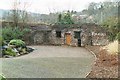
Ancient warm water spring used since Roman times.
You may be viewing yesterday's version of this page. To see the most up to date information please register for a free account.
")
")
")
Do not use the above information on other web sites or publications without permission of the contributor.
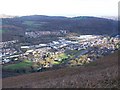
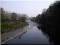
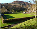
Nearby Images from Geograph Britain and Ireland:
©2011(licence)
©2011(licence)
©2008(licence)
©2011(licence)
©2011(licence)
The above images may not be of the site on this page, they are loaded from Geograph.
Please Submit an Image of this site or go out and take one for us!
Click here to see more info for this site
Nearby sites
Key: Red: member's photo, Blue: 3rd party photo, Yellow: other image, Green: no photo - please go there and take one, Grey: site destroyed
Download sites to:
KML (Google Earth)
GPX (GPS waypoints)
CSV (Garmin/Navman)
CSV (Excel)
To unlock full downloads you need to sign up as a Contributory Member. Otherwise downloads are limited to 50 sites.
Turn off the page maps and other distractions
Nearby sites listing. In the following links * = Image available
1.6km W 264° Garth Hill* Round Barrow(s) (ST103835)
1.7km SSE 160° Lesser Garth Cave* Cave or Rock Shelter (ST125820)
2.5km SW 218° Ffynnoncattwg* Holy Well or Sacred Spring (ST10348165)
2.8km SSW 201° Llwynda-ddu Hillfort (ST10878100)
3.4km ESE 104° Wennalt Camp Ancient Village or Settlement (ST15208275)
3.8km SW 222° Craig-y-Parc Ancient Village or Settlement (ST09298084)
3.9km SSE 156° Radyr Woods Burnt Mound* Artificial Mound (ST13438003)
4.4km SSE 154° Pistyll Golau Holy Well or Sacred Spring (ST13787962)
4.4km WSW 249° Cae'rarfau* Chambered Tomb (ST0772582144)
4.6km NE 46° Gorsedd Stones (Caerphilly)* Modern Stone Circle etc (ST153868)
5.7km SSW 198° Sant-Y-Nyll Round Barrow(s) (ST10077829)
6.4km S 181° Museum of Welsh Life, St Fagans* Museum (ST117772)
6.5km S 179° St Fagan's Well Holy Well or Sacred Spring (ST11917712)
6.7km SE 146° St Teilo's Well, Llandaff* Holy Well or Sacred Spring (ST15567805)
7.4km NNE 13° The Bryn Cairn (ST13689082)
7.5km NNW 329° Carreg Siglio* Modern Stone Circle etc (ST082901)
7.6km NNE 18° Bryn Owen Farm Cairns Cairn (ST144908)
7.6km WNW 297° Tarren Deusant* Holy Well or Sacred Spring (ST05208721)
7.6km NNE 12° The Bryn Earthwork Ring Cairn (ST13619105)
7.7km NNW 328° Coed-Pen-Maen Common* Ring Cairn (ST07989031)
8.0km N 6° Waun Deiliaid Ring Cairn (ST12939162)
8.5km N 349° Carneddi Llwydion* Round Cairn (ST105920)
8.6km E 87° Graig Llwyn Iron Age Fort* Hillfort (ST205840)
8.7km N 352° Ffos-yr-Haidal 1, Mynydd Eglwysilan* Rock Art (ST10899224)
8.8km S 170° Caerau (Cardiff)* Hillfort (ST13377498)
View more nearby sites and additional images

")
 We would like to know more about this location. Please feel free to add a brief description and any relevant information in your own language.
 Wir möchten mehr über diese Stätte erfahren. Bitte zögern Sie nicht, eine kurze Beschreibung und relevante Informationen in Deutsch hinzuzufügen.
 Nous aimerions en savoir encore un peu sur les lieux. S'il vous plaît n'hesitez pas à ajouter une courte description et tous les renseignements pertinents dans votre propre langue.
 Quisieramos informarnos un poco más de las lugares. No dude en añadir una breve descripción y otros datos relevantes en su propio idioma.