


<< Our Photo Pages >> Carneddi Llwydion - Round Cairn in Wales in South Glamorgan
Submitted by enkidu41 on Sunday, 12 December 2004 Page Views: 8734
Neolithic and Bronze AgeSite Name: Carneddi LlwydionCountry: Wales
NOTE: This site is 1.1 km away from the location you searched for.
County: South Glamorgan Type: Round Cairn
Nearest Town: Caerphilly
Map Ref: ST105920
Latitude: 51.619681N Longitude: 3.294161W
Condition:
| 5 | Perfect |
| 4 | Almost Perfect |
| 3 | Reasonable but with some damage |
| 2 | Ruined but still recognisable as an ancient site |
| 1 | Pretty much destroyed, possibly visible as crop marks |
| 0 | No data. |
| -1 | Completely destroyed |
| 5 | Superb |
| 4 | Good |
| 3 | Ordinary |
| 2 | Not Good |
| 1 | Awful |
| 0 | No data. |
| 5 | Can be driven to, probably with disabled access |
| 4 | Short walk on a footpath |
| 3 | Requiring a bit more of a walk |
| 2 | A long walk |
| 1 | In the middle of nowhere, a nightmare to find |
| 0 | No data. |
| 5 | co-ordinates taken by GPS or official recorded co-ordinates |
| 4 | co-ordinates scaled from a detailed map |
| 3 | co-ordinates scaled from a bad map |
| 2 | co-ordinates of the nearest village |
| 1 | co-ordinates of the nearest town |
| 0 | no data |
Be the first person to rate this site - see the 'Contribute!' box in the right hand menu.
Internal Links:
External Links:
")
You may be viewing yesterday's version of this page. To see the most up to date information please register for a free account.
Do not use the above information on other web sites or publications without permission of the contributor.
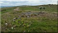
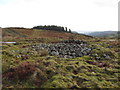
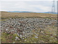
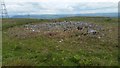
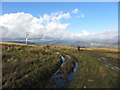
Nearby Images from Geograph Britain and Ireland:
©2019(licence)
©2014(licence)
©2013(licence)
©2019(licence)
©2014(licence)
The above images may not be of the site on this page, they are loaded from Geograph.
Please Submit an Image of this site or go out and take one for us!
Click here to see more info for this site
Nearby sites
Key: Red: member's photo, Blue: 3rd party photo, Yellow: other image, Green: no photo - please go there and take one, Grey: site destroyed
Download sites to:
KML (Google Earth)
GPX (GPS waypoints)
CSV (Garmin/Navman)
CSV (Excel)
To unlock full downloads you need to sign up as a Contributory Member. Otherwise downloads are limited to 50 sites.
Turn off the page maps and other distractions
Nearby sites listing. In the following links * = Image available
457m ENE 57° Ffos-yr-Haidal 1, Mynydd Eglwysilan* Rock Art (ST10899224)
2.5km E 98° Waun Deiliaid Ring Cairn (ST12939162)
3.0km SW 229° Carreg Siglio* Modern Stone Circle etc (ST082901)
3.0km SW 235° Coed-Pen-Maen Common* Ring Cairn (ST07989031)
3.2km ESE 106° The Bryn Earthwork Ring Cairn (ST13619105)
3.4km ESE 109° The Bryn Cairn (ST13689082)
4.1km ESE 106° Bryn Owen Farm Cairns Cairn (ST144908)
5.8km NNE 21° Maen Cattwg* Rock Art (ST12709742)
6.3km E 89° Mynydd Bach Cairnfield Cairn (ST16799200)
6.3km E 89° Mynydd Bach Cairn. Cairn (ST16799197)
6.3km E 91° Mynydd Bach Cairn 1 Cairn (ST16799182)
6.5km E 84° Mynydd Bach Cairn 2* Round Barrow(s) (ST17019259)
6.6km E 90° Pont Bren Gwyn Ring Cairn (ST17089194)
6.8km ENE 73° Stone near Tyle-Gwyn, Wyllie Standing Stone (Menhir) (ST17069386)
6.9km E 93° Twyn Cae-Hugh* Round Barrow(s) (ST17379149)
7.1km SE 136° Gorsedd Stones (Caerphilly)* Modern Stone Circle etc (ST153868)
7.1km SW 227° Tarren Deusant* Holy Well or Sacred Spring (ST05208721)
7.2km NNW 343° Tir-Cook Cairn Cairn (ST085989)
7.3km N 350° Coed Cae Cairns and field system Cairn (ST094992)
7.6km NNE 19° Gelligaer Common Cairn Cairn (ST131991)
7.7km E 99° Twyn-Yr-Oerfel B* Round Barrow(s) (ST18109068)
8.0km E 99° Twyn-Yr-Oerfel A* Round Barrow(s) (ST18399058)
8.2km NNW 344° Mynydd Y Capel Cairns Cairn (ST084999)
8.2km NNW 344° Mynydd Y Capel Standing Stone* Standing Stone (Menhir) (ST084999)
8.3km NNW 344° Mynydd Y Capel Cairnfield* Cairn (SO0835100032)
View more nearby sites and additional images


 We would like to know more about this location. Please feel free to add a brief description and any relevant information in your own language.
 Wir möchten mehr über diese Stätte erfahren. Bitte zögern Sie nicht, eine kurze Beschreibung und relevante Informationen in Deutsch hinzuzufügen.
 Nous aimerions en savoir encore un peu sur les lieux. S'il vous plaît n'hesitez pas à ajouter une courte description et tous les renseignements pertinents dans votre propre langue.
 Quisieramos informarnos un poco más de las lugares. No dude en añadir una breve descripción y otros datos relevantes en su propio idioma.