


<< Our Photo Pages >> Moel Maen Efa - Barrow Cemetery in Wales in Denbighshire
Submitted by TimPrevett on Saturday, 09 October 2004 Page Views: 7633
Neolithic and Bronze AgeSite Name: Moel Maen EfaCountry: Wales
NOTE: This site is 1.2 km away from the location you searched for.
County: Denbighshire Type: Barrow Cemetery
Nearest Town: St Asaph Nearest Village: Rhuallt
Map Ref: SJ087743
Latitude: 53.257820N Longitude: 3.370068W
Condition:
| 5 | Perfect |
| 4 | Almost Perfect |
| 3 | Reasonable but with some damage |
| 2 | Ruined but still recognisable as an ancient site |
| 1 | Pretty much destroyed, possibly visible as crop marks |
| 0 | No data. |
| -1 | Completely destroyed |
| 5 | Superb |
| 4 | Good |
| 3 | Ordinary |
| 2 | Not Good |
| 1 | Awful |
| 0 | No data. |
| 5 | Can be driven to, probably with disabled access |
| 4 | Short walk on a footpath |
| 3 | Requiring a bit more of a walk |
| 2 | A long walk |
| 1 | In the middle of nowhere, a nightmare to find |
| 0 | No data. |
| 5 | co-ordinates taken by GPS or official recorded co-ordinates |
| 4 | co-ordinates scaled from a detailed map |
| 3 | co-ordinates scaled from a bad map |
| 2 | co-ordinates of the nearest village |
| 1 | co-ordinates of the nearest town |
| 0 | no data |
Internal Links:
External Links:
I have visited· I would like to visit
TimPrevett has visited here
")
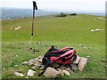
Two heavily ploughed out barrows on the summit of Moel Maen Efa, one topped by the trig point.
The highest barrow shows signs of having been dug in places, with large square sods & turf loose around the already considerably denuded summit. Metal detectors used irresponsibly?
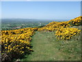
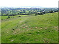
Access from nearby footpaths, with spectacular views over the Vale of Clwyd, the Wirral, and even Liverpool City Centre.
A large cross to the west is made of two railway sleepers oozing tar, leaning to the east. Nothing of antiquity is obvious about the feature.
You may be viewing yesterday's version of this page. To see the most up to date information please register for a free account.
Do not use the above information on other web sites or publications without permission of the contributor.
Nearby Images from Geograph Britain and Ireland:

©2010(licence)
©2013(licence)
©2009(licence)
©2009(licence)
©2020(licence)
The above images may not be of the site on this page, they are loaded from Geograph.
Please Submit an Image of this site or go out and take one for us!
Click here to see more info for this site
Nearby sites
Key: Red: member's photo, Blue: 3rd party photo, Yellow: other image, Green: no photo - please go there and take one, Grey: site destroyed
Download sites to:
KML (Google Earth)
GPX (GPS waypoints)
CSV (Garmin/Navman)
CSV (Excel)
To unlock full downloads you need to sign up as a Contributory Member. Otherwise downloads are limited to 50 sites.
Turn off the page maps and other distractions
Nearby sites listing. In the following links * = Image available
1.2km S 172° Penuchaf Cairn (SJ08837315)
1.6km ESE 111° Coed Bron Fawr* Barrow Cemetery (SJ10167372)
1.8km S 185° Ffynnon Beuno (Caves)* Cave or Rock Shelter (SJ0849972500)
1.8km S 187° Cae Gwyn* Cave or Rock Shelter (SJ0843972501)
1.9km NNE 17° Criafol* Round Barrow(s) (SJ09317611)
2.0km S 190° St Beuno's Well (Tremeirchion)* Holy Well or Sacred Spring (SJ083723)
2.0km SSE 154° Cefn Du Ancient Village or Settlement (SJ0956272450)
2.2km NNE 25° Pany Y Dulath Round Barrow(s) (SJ09677624)
2.4km NNW 334° Llyn-Y-Gorseddau 1 Round Barrow(s) (SJ07657651)
2.5km NNW 335° Llyn-Y-Gorseddau 2 Round Barrow(s) (SJ07687657)
2.5km NNW 334° Llyn-Y-Gorseddau 3 Round Barrow(s) (SJ07647662)
2.8km NNE 30° Hendre Bach Round Barrow(s) (SJ10137671)
2.9km NE 55° Traveller's Inn* Round Barrow(s) (SJ111759)
3.1km NNW 338° Aelwyd Uchaf (Cottage) Barrows Round Barrow(s) (SJ0758577185)
3.6km SSE 166° Moel-y-Gaer (Bodfari)* Hillfort (SJ09527080)
3.7km NNW 332° Marion Bach 1 Round Barrow(s) (SJ07057759)
3.8km NNW 336° Marion Bach 2 Round Barrow(s) (SJ07217782)
3.8km NNW 340° Marian Ffrith Hillfort (SJ0746877947)
3.9km N 2° Cae Bryn Round Barrow(s) (SJ08917821)
4.6km W 265° Ysgol Glan Clwyd Modern Circle* Modern Stone Circle etc (SJ0412074000)
4.8km NNW 329° Moel Hiraddug* Hillfort (SJ063785)
5.1km ENE 71° Ffrith-Y-Garreg-Wen* Round Barrow(s) (SJ13587589)
5.2km N 357° Hen Dy Round Barrow(s) (SJ08547950)
5.8km N 358° Gop Caves* Cave or Rock Shelter (SJ08648009)
5.8km NNW 327° Dyserth Church* Ancient Cross (SJ056792)
View more nearby sites and additional images


 We would like to know more about this location. Please feel free to add a brief description and any relevant information in your own language.
 Wir möchten mehr über diese Stätte erfahren. Bitte zögern Sie nicht, eine kurze Beschreibung und relevante Informationen in Deutsch hinzuzufügen.
 Nous aimerions en savoir encore un peu sur les lieux. S'il vous plaît n'hesitez pas à ajouter une courte description et tous les renseignements pertinents dans votre propre langue.
 Quisieramos informarnos un poco más de las lugares. No dude en añadir una breve descripción y otros datos relevantes en su propio idioma.