


<< Our Photo Pages >> Bwlch Maen Gwynedd - Cairn in Wales in Wrexham
Submitted by postman on Thursday, 25 October 2012 Page Views: 3323
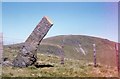
Neolithic and Bronze AgeSite Name: Bwlch Maen GwyneddCountry: Wales County: Wrexham Type: Cairn
Nearest Town: Llandrillo
Map Ref: SJ07953364
Latitude: 52.892301N Longitude: 3.369658W
Condition:
| 5 | Perfect |
| 4 | Almost Perfect |
| 3 | Reasonable but with some damage |
| 2 | Ruined but still recognisable as an ancient site |
| 1 | Pretty much destroyed, possibly visible as crop marks |
| 0 | No data. |
| -1 | Completely destroyed |
| 5 | Superb |
| 4 | Good |
| 3 | Ordinary |
| 2 | Not Good |
| 1 | Awful |
| 0 | No data. |
| 5 | Can be driven to, probably with disabled access |
| 4 | Short walk on a footpath |
| 3 | Requiring a bit more of a walk |
| 2 | A long walk |
| 1 | In the middle of nowhere, a nightmare to find |
| 0 | No data. |
| 5 | co-ordinates taken by GPS or official recorded co-ordinates |
| 4 | co-ordinates scaled from a detailed map |
| 3 | co-ordinates scaled from a bad map |
| 2 | co-ordinates of the nearest village |
| 1 | co-ordinates of the nearest town |
| 0 | no data |
Internal Links:
External Links:
")
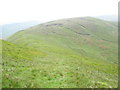
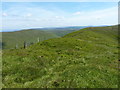
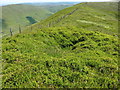
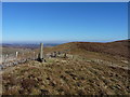
Perched on a thin ridge connecting cadair Berwyn to Tomle. A delicate cairn with a hollow in its top. Visible from miles to either north or south. Without the mist it would be good to linger a while, very good scenery.
You may be viewing yesterday's version of this page. To see the most up to date information please register for a free account.
Do not use the above information on other web sites or publications without permission of the contributor.
Nearby Images from Geograph Britain and Ireland:
©2007(licence)
©2019(licence)
©2019(licence)
©2018(licence)
©2007(licence)
The above images may not be of the site on this page, they are loaded from Geograph.
Please Submit an Image of this site or go out and take one for us!
Click here to see more info for this site
Nearby sites
Key: Red: member's photo, Blue: 3rd party photo, Yellow: other image, Green: no photo - please go there and take one, Grey: site destroyed
Download sites to:
KML (Google Earth)
GPX (GPS waypoints)
CSV (Garmin/Navman)
CSV (Excel)
To unlock full downloads you need to sign up as a Contributory Member. Otherwise downloads are limited to 50 sites.
Turn off the page maps and other distractions
Nearby sites listing. In the following links * = Image available
283m SSW 211° Berwyn mountains Marker stones* Marker Stone (SJ078334)
1.1km NNW 346° Bwrdd Arthur* Cairn (SJ077347)
1.2km SW 217° Cadair Berwyn* Cairn (SJ072327)
1.4km SSW 212° Cader Berwyn Cairn 2* Cairn (SJ07173245)
1.7km SE 146° Cwm Maen Gwynedd Stone Row II Stone Row / Alignment (SJ0885332238)
1.7km SSE 149° Cwm Maen Gwynedd Stone Row I Stone Row / Alignment (SJ0881132142)
2.2km SW 217° Moel Sych* Cairn (SJ066319)
3.1km NNE 21° Careg-Y-Caws* Cairn (SJ09133650)
3.1km W 263° Pennant* Round Cairn (SJ04823331)
3.1km N 9° Pen Bwlch Llandrillo Cairn (SJ08513674)
3.3km NW 319° Cerrig Bwlch Y Fedw* Stone Circle (SJ05873615)
3.3km W 266° Cwm Tywyll* Ring Cairn (SJ04683346)
3.6km WSW 257° Nant Esgeiriau* Round Cairn (SJ044329)
3.7km SSW 212° Cwm Rhiwiau* Stone Circle (SJ059305)
3.8km W 267° Cefn Penagored Ridge Cairns* Cairn (SJ041335)
4.0km SSW 192° Afon Disgynfa* Cairn (SJ07042971)
4.0km W 268° Cefn Penagored Cairn and Ring Cairn* Cairn (SJ039336)
4.1km SSW 211° Rhos y Beddau (Rows)* Multiple Stone Rows / Avenue (SJ0579530205)
4.1km SSW 211° Rhos Y Beddau (Circle)* Stone Circle (SJ058302)
4.2km NW 325° Moel Ty Uchaf* Stone Circle (SJ05613717)
4.6km W 277° Penagored Standing Stone* Standing Stone (Menhir) (SJ034343)
4.6km W 265° Rhyd y Gethin Standing Stone (Menhir) (SJ03303330)
5.0km W 259° Yr Aran* Barrow Cemetery (SJ03053279)
5.7km NNE 18° Nant Croes Y Wernen* Stone Circle (SJ09813906)
5.9km S 187° Glan Hafon cairn* Cairn (SJ07152776)
View more nearby sites and additional images


 We would like to know more about this location. Please feel free to add a brief description and any relevant information in your own language.
 Wir möchten mehr über diese Stätte erfahren. Bitte zögern Sie nicht, eine kurze Beschreibung und relevante Informationen in Deutsch hinzuzufügen.
 Nous aimerions en savoir encore un peu sur les lieux. S'il vous plaît n'hesitez pas à ajouter une courte description et tous les renseignements pertinents dans votre propre langue.
 Quisieramos informarnos un poco más de las lugares. No dude en añadir una breve descripción y otros datos relevantes en su propio idioma.