


<< Our Photo Pages >> Cwmberwyn Camp - Hillfort in Wales in Powys
Submitted by geoffstickland on Monday, 21 September 2020 Page Views: 1711
Iron Age and Later PrehistorySite Name: Cwmberwyn CampCountry: Wales County: Powys Type: Hillfort
Nearest Town: Builth Wells Nearest Village: Llansantfraed in Elwel
Map Ref: SO07275481
Latitude: 52.183715N Longitude: 3.357722W
Condition:
| 5 | Perfect |
| 4 | Almost Perfect |
| 3 | Reasonable but with some damage |
| 2 | Ruined but still recognisable as an ancient site |
| 1 | Pretty much destroyed, possibly visible as crop marks |
| 0 | No data. |
| -1 | Completely destroyed |
| 5 | Superb |
| 4 | Good |
| 3 | Ordinary |
| 2 | Not Good |
| 1 | Awful |
| 0 | No data. |
| 5 | Can be driven to, probably with disabled access |
| 4 | Short walk on a footpath |
| 3 | Requiring a bit more of a walk |
| 2 | A long walk |
| 1 | In the middle of nowhere, a nightmare to find |
| 0 | No data. |
| 5 | co-ordinates taken by GPS or official recorded co-ordinates |
| 4 | co-ordinates scaled from a detailed map |
| 3 | co-ordinates scaled from a bad map |
| 2 | co-ordinates of the nearest village |
| 1 | co-ordinates of the nearest town |
| 0 | no data |
Internal Links:
External Links:
I have visited· I would like to visit
SolarMegalith would like to visit
geoffstickland has visited here
")
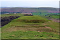
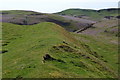
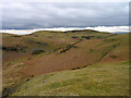
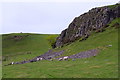
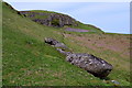
There are two banks and associated ditches, the larger, inner bank is about 20' high and the outer 3' high. The inner space of the camp is set on a slope and traces can be seen of hut foundations. The camp affords far reaching views in all directions. It is one of the higher camps in this area at around 400 metres.
You may be viewing yesterday's version of this page. To see the most up to date information please register for a free account.
")
")
Do not use the above information on other web sites or publications without permission of the contributor.
Nearby Images from Geograph Britain and Ireland:
©2018(licence)
©2018(licence)
©2014(licence)
©2018(licence)
©2018(licence)
The above images may not be of the site on this page, they are loaded from Geograph.
Please Submit an Image of this site or go out and take one for us!
Click here to see more info for this site
Nearby sites
Key: Red: member's photo, Blue: 3rd party photo, Yellow: other image, Green: no photo - please go there and take one, Grey: site destroyed
Download sites to:
KML (Google Earth)
GPX (GPS waypoints)
CSV (Garmin/Navman)
CSV (Excel)
To unlock full downloads you need to sign up as a Contributory Member. Otherwise downloads are limited to 50 sites.
Turn off the page maps and other distractions
Nearby sites listing. In the following links * = Image available
607m SE 146° Cwm-Berwyn Round Cairn* Cairn (SO076543)
731m NW 308° Carneddau Hill Cairn II* Round Barrow(s) (SO06705527)
889m NW 314° Carneddau Hill Cairn I.* Round Barrow(s) (SO06645544)
959m ESE 112° Cilberllan Ring Cairn* Cairn (SO0815654436)
984m SW 220° Carneddau Hill Cairn* Cairn (SO06625407)
1.0km WSW 253° Newmead Farm Cairn 1* Cairn (SO06305454)
1.0km WSW 251° Newmead Farm Cairn 2* Cairn (SO06295450)
1.1km SW 231° Four Parishes Standing Stone* Standing Stone (Menhir) (SO06395413)
1.3km E 89° The Gaer* Hillfort (SO08555480)
1.3km SW 228° Carneddau West* Cairn (SO06295395)
1.3km SW 228° Newmead Farm Cairn 3* Cairn (SO0627153958)
1.8km ESE 113° Bryntwppa* Stone Row / Alignment (SO08905410)
1.8km SW 219° Carneddau Hill Stone* Standing Stone (Menhir) (SO06105344)
1.9km NE 47° Castle Bank (Radnorshire)* Hillfort (SO08695608)
1.9km SSW 207° Caer Einon* Hillfort (SO06365309)
2.1km E 88° Perthi Common Cairns 1, 2, 3, 4* Cairn (SO0940654856)
2.2km NNE 16° Upper House Cairns I,II & III* Cairn (SO079569)
2.3km SW 219° Gaer Fawr (Llanelwedd)* Hillfort (SO05795308)
2.3km NNE 30° Court Standing Stone* Standing Stone (Menhir) (SO08495680)
2.7km NE 35° Court Stone Row* Stone Row / Alignment (SO08865695)
3.1km NE 48° Gwernfach Cairns I,II,III & IV* Cairn (SO096568)
3.3km ENE 62° Cwm Stone* Standing Stone (Menhir) (SO10185630)
4.1km NNE 31° Gelli Hill Circle* Stone Circle (SO095583)
4.2km NNE 30° Gelli Hill Standing Stone* Standing Stone (Menhir) (SO09425837)
4.2km WSW 244° Castell Caemardy* Artificial Mound (SO03465301)
View more nearby sites and additional images


 We would like to know more about this location. Please feel free to add a brief description and any relevant information in your own language.
 Wir möchten mehr über diese Stätte erfahren. Bitte zögern Sie nicht, eine kurze Beschreibung und relevante Informationen in Deutsch hinzuzufügen.
 Nous aimerions en savoir encore un peu sur les lieux. S'il vous plaît n'hesitez pas à ajouter une courte description et tous les renseignements pertinents dans votre propre langue.
 Quisieramos informarnos un poco más de las lugares. No dude en añadir una breve descripción y otros datos relevantes en su propio idioma.