


<< Our Photo Pages >> Llyn Mawr East - Ring Cairn in Wales in Powys
Submitted by postman on Thursday, 15 November 2012 Page Views: 2329
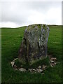
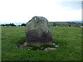
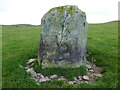
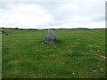
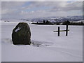
Neolithic and Bronze AgeSite Name: Llyn Mawr EastCountry: Wales County: Powys Type: Ring Cairn
Nearest Town: Newtown Nearest Village: Clatter
Map Ref: SO01369700
Latitude: 52.561860N Longitude: 3.45656W
Condition:
| 5 | Perfect |
| 4 | Almost Perfect |
| 3 | Reasonable but with some damage |
| 2 | Ruined but still recognisable as an ancient site |
| 1 | Pretty much destroyed, possibly visible as crop marks |
| 0 | No data. |
| -1 | Completely destroyed |
| 5 | Superb |
| 4 | Good |
| 3 | Ordinary |
| 2 | Not Good |
| 1 | Awful |
| 0 | No data. |
| 5 | Can be driven to, probably with disabled access |
| 4 | Short walk on a footpath |
| 3 | Requiring a bit more of a walk |
| 2 | A long walk |
| 1 | In the middle of nowhere, a nightmare to find |
| 0 | No data. |
| 5 | co-ordinates taken by GPS or official recorded co-ordinates |
| 4 | co-ordinates scaled from a detailed map |
| 3 | co-ordinates scaled from a bad map |
| 2 | co-ordinates of the nearest village |
| 1 | co-ordinates of the nearest town |
| 0 | no data |
Internal Links:
External Links:
")
Really not very far from the large standing stone just a hundred yards south. Brilliant views south into the valley, and west is the long crag of Craig y Llyn Mawr. Someone should have been here before now, and my visit was three years ago.
You may be viewing yesterday's version of this page. To see the most up to date information please register for a free account.
")
")
")
Do not use the above information on other web sites or publications without permission of the contributor.
Nearby Images from Geograph Britain and Ireland:
©2021(licence)
©2021(licence)
©2021(licence)
©2021(licence)
©2010(licence)
The above images may not be of the site on this page, they are loaded from Geograph.
Please Submit an Image of this site or go out and take one for us!
Click here to see more info for this site
Nearby sites
Key: Red: member's photo, Blue: 3rd party photo, Yellow: other image, Green: no photo - please go there and take one, Grey: site destroyed
Download sites to:
KML (Google Earth)
GPX (GPS waypoints)
CSV (Garmin/Navman)
CSV (Excel)
To unlock full downloads you need to sign up as a Contributory Member. Otherwise downloads are limited to 50 sites.
Turn off the page maps and other distractions
Nearby sites listing. In the following links * = Image available
156m SSE 156° Clogau Standing Stone* Standing Stone (Menhir) (SO0142096856)
994m ENE 65° Llyn-y-Tarw Hut Circle* Ancient Village or Settlement (SO0227597395)
1.1km W 276° Llyn Mawr South* Standing Stone (Menhir) (SO00249714)
1.2km ENE 77° Llyn-y-Tarw* Stone Circle (SO02579726)
1.9km NW 314° Lluest Uchaf* Stone Row / Alignment (SO00049832)
2.1km WNW 301° Craig y Llyn Mawr stone circle.* Stone Circle (SN996981)
3.4km NNW 334° Y Capel* Stone Circle (SH99950005)
5.6km N 11° Llidiardau mawr Stone Row / Alignment (SJ025025)
7.0km S 177° Cefn Carnedd Hillfort (SO016900)
7.0km SSW 194° Pont Ar Daf Cairn Cairn (SN995902)
7.1km WSW 237° Esgair y Groes* Standing Stone (Menhir) (SN9532793293)
7.7km S 174° Nant-Yr-Hebog* Ancient Village or Settlement (SO02058932)
7.8km SSW 200° Gaer Bella Hillfort (SN98508969)
8.0km WSW 257° Bryn yr Aran Stone Circle (SN935953)
8.5km WSW 256° Esgair Draenllwyn Stone Row / Alignment (SN93039505)
9.3km W 263° Trannon Moor* Cairn (SN92049609)
9.5km W 261° Careg Lwyd* Stone Row / Alignment (SN91949569)
9.5km W 261° Trannon circles* Ring Cairn (SN91899577)
9.6km W 262° Twr-Gwyn Mawr* Cairn (SN9181695935)
9.7km W 281° Ffridd yr Ystrad Standing Stone Standing Stone (Menhir) (SN9188699066)
10.6km ESE 118° Newtown Gorsedd Circle* Modern Stone Circle etc (SO1057591808)
10.7km WNW 287° Newydd Fynyddog Cairn (SH912003)
10.9km SE 131° Castell-Y-Dail* Ancient Village or Settlement (SO09448972)
11.2km SW 216° Pen-Y-Castell (Llanidloes Without)* Hillfort (SN94548809)
11.5km WNW 287° Lled-Croen-Yr-Ych* Stone Circle (SH90400055)
View more nearby sites and additional images


 We would like to know more about this location. Please feel free to add a brief description and any relevant information in your own language.
 Wir möchten mehr über diese Stätte erfahren. Bitte zögern Sie nicht, eine kurze Beschreibung und relevante Informationen in Deutsch hinzuzufügen.
 Nous aimerions en savoir encore un peu sur les lieux. S'il vous plaît n'hesitez pas à ajouter une courte description et tous les renseignements pertinents dans votre propre langue.
 Quisieramos informarnos un poco más de las lugares. No dude en añadir una breve descripción y otros datos relevantes en su propio idioma.