


<< Text Pages >> Cefn Esgair - Ring Cairn in Wales in Mid Glamorgan
Submitted by vicky on Wednesday, 25 February 2004 Page Views: 6258
Neolithic and Bronze AgeSite Name: Cefn EsgairCountry: Wales
NOTE: This site is 1.6 km away from the location you searched for.
County: Mid Glamorgan Type: Ring Cairn
Nearest Town: Merthyr Tydfil Nearest Village: Llwyn-on
Map Ref: SN974134 Landranger Map Number: 160
Latitude: 51.809788N Longitude: 3.489625W
Condition:
| 5 | Perfect |
| 4 | Almost Perfect |
| 3 | Reasonable but with some damage |
| 2 | Ruined but still recognisable as an ancient site |
| 1 | Pretty much destroyed, possibly visible as crop marks |
| 0 | No data. |
| -1 | Completely destroyed |
| 5 | Superb |
| 4 | Good |
| 3 | Ordinary |
| 2 | Not Good |
| 1 | Awful |
| 0 | No data. |
| 5 | Can be driven to, probably with disabled access |
| 4 | Short walk on a footpath |
| 3 | Requiring a bit more of a walk |
| 2 | A long walk |
| 1 | In the middle of nowhere, a nightmare to find |
| 0 | No data. |
| 5 | co-ordinates taken by GPS or official recorded co-ordinates |
| 4 | co-ordinates scaled from a detailed map |
| 3 | co-ordinates scaled from a bad map |
| 2 | co-ordinates of the nearest village |
| 1 | co-ordinates of the nearest town |
| 0 | no data |
Internal Links:
External Links:
Ring Cairn in Mid Glamorgan (Merthyr Tydfil)
Have you visited this site? Please add a comment below.
You may be viewing yesterday's version of this page. To see the most up to date information please register for a free account.
Do not use the above information on other web sites or publications without permission of the contributor.
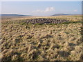
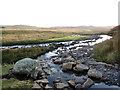
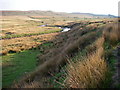
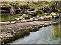
Nearby Images from Geograph Britain and Ireland:
©2008(licence)
©2016(licence)
©2008(licence)
©2021(licence)
©2011(licence)
The above images may not be of the site on this page, they are loaded from Geograph.
Please Submit an Image of this site or go out and take one for us!
Click here to see more info for this site
Nearby sites
Key: Red: member's photo, Blue: 3rd party photo, Yellow: other image, Green: no photo - please go there and take one, Grey: site destroyed
Download sites to:
KML (Google Earth)
GPX (GPS waypoints)
CSV (Garmin/Navman)
CSV (Excel)
To unlock full downloads you need to sign up as a Contributory Member. Otherwise downloads are limited to 50 sites.
Turn off the page maps and other distractions
Nearby sites listing. In the following links * = Image available
796m SSE 164° Cadair Fawr east cairn* Cairn (SN9760912631)
1.2km WSW 246° Blaen Hepste* Henge (SN9633012960)
1.2km SSE 163° Cadair Fawr Cairn* Cairn (SN9773612218)
1.4km SSE 166° Blaen Cadlan Uchaf* Cairn (SN9772011990)
2.1km SSE 147° Twyn Bryn Glas Cairn* Cairn (SN9850011660)
2.7km SSE 151° Cwm Cadlan 3* Ring Cairn (SN98641101)
2.7km SSE 159° Cwm Cadlan 2* Ring Cairn (SN98321087)
2.7km SSE 154° Cwm Cadlan 1* Round Cairn (SN98551095)
2.9km NNW 335° Bedd Llywarch* Standing Stones (SN96251604)
2.9km NW 310° Pen Fathor Uchaf* Cairn (SN95211528)
3.1km SSE 169° Cefn Sychpant* Round Cairn (SN97951036)
3.6km WSW 255° Carn yr Arian* Round Cairn (SN93901253)
4.1km E 95° Cefn Car Standing Stones* Standing Stones (SO01491299)
4.5km ESE 108° Fedw Standing Stone Standing Stone (Menhir) (SO01701191)
4.5km S 180° Mynydd y Glog* Cairn (SN97270886)
5.0km E 83° Nant Gwinau* Stone Row / Alignment (SO02361390)
5.2km ESE 110° Coedcae'r Gwarthog* Barrow Cemetery (SO02241154)
5.6km ESE 116° Cefn Cil-Sanws* Ring Cairn (SO02421081)
5.7km W 275° Gelli-Nedd* Hillfort (SN91741400)
6.0km WNW 292° Maen Madoc* Standing Stone (Menhir) (SN91821577)
6.1km W 262° Dyffryn Nedd Hillfort (SN913127)
6.1km NW 320° Fan Llia Summit Cairn* Cairn (SN9353218168)
6.3km ENE 63° Bwlch Gwyn 1 Standing Stone (Menhir) (SO03121612)
6.3km ENE 64° Bwlch Gwyn 2 Standing Stone (Menhir) (SO03151611)
6.8km NW 318° Fan Llia Round Cairn (2)* Cairn (SN92971855)
View more nearby sites and additional images


 We would like to know more about this location. Please feel free to add a brief description and any relevant information in your own language.
 Wir möchten mehr über diese Stätte erfahren. Bitte zögern Sie nicht, eine kurze Beschreibung und relevante Informationen in Deutsch hinzuzufügen.
 Nous aimerions en savoir encore un peu sur les lieux. S'il vous plaît n'hesitez pas à ajouter une courte description et tous les renseignements pertinents dans votre propre langue.
 Quisieramos informarnos un poco más de las lugares. No dude en añadir una breve descripción y otros datos relevantes en su propio idioma.