

<< Text Pages >> Loch Kindar - Crannog in Scotland in Dumfries and Galloway
Submitted by SolarMegalith on Monday, 16 September 2013 Page Views: 4803
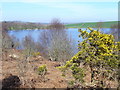
Iron Age and Later PrehistorySite Name: Loch KindarCountry: Scotland County: Dumfries and Galloway Type: Crannog
Nearest Village: Inglestonford
Map Ref: NX96896423
Latitude: 54.961999N Longitude: 3.61192W
Condition:
| 5 | Perfect |
| 4 | Almost Perfect |
| 3 | Reasonable but with some damage |
| 2 | Ruined but still recognisable as an ancient site |
| 1 | Pretty much destroyed, possibly visible as crop marks |
| 0 | No data. |
| -1 | Completely destroyed |
| 5 | Superb |
| 4 | Good |
| 3 | Ordinary |
| 2 | Not Good |
| 1 | Awful |
| 0 | No data. |
| 5 | Can be driven to, probably with disabled access |
| 4 | Short walk on a footpath |
| 3 | Requiring a bit more of a walk |
| 2 | A long walk |
| 1 | In the middle of nowhere, a nightmare to find |
| 0 | No data. |
| 5 | co-ordinates taken by GPS or official recorded co-ordinates |
| 4 | co-ordinates scaled from a detailed map |
| 3 | co-ordinates scaled from a bad map |
| 2 | co-ordinates of the nearest village |
| 1 | co-ordinates of the nearest town |
| 0 | no data |
Internal Links:
External Links:
Crannog in Dumfries and Galloway
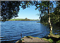
Remains of a crannog preserved as a pile of stones forming a circular islet of 16m diameter.
Loch Kindar on ScotlandsPlaces.
You may be viewing yesterday's version of this page. To see the most up to date information please register for a free account.
Do not use the above information on other web sites or publications without permission of the contributor.
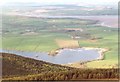
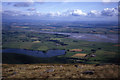
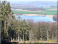
Nearby Images from Geograph Britain and Ireland:
©2008(licence)
©2020(licence)
©2007(licence)
©2018(licence)
©2007(licence)
The above images may not be of the site on this page, they are loaded from Geograph.
Please Submit an Image of this site or go out and take one for us!
Click here to see more info for this site
Nearby sites
Key: Red: member's photo, Blue: 3rd party photo, Yellow: other image, Green: no photo - please go there and take one, Grey: site destroyed
Download sites to:
KML (Google Earth)
GPX (GPS waypoints)
CSV (Garmin/Navman)
CSV (Excel)
To unlock full downloads you need to sign up as a Contributory Member. Otherwise downloads are limited to 50 sites.
Turn off the page maps and other distractions
Nearby sites listing. In the following links * = Image available
839m N 358° Lochhill* Chambered Cairn (NX96886507)
1.5km ENE 70° Ingleston Cairn (NX983647)
4.9km SW 234° Slewcairn NE* Cairn (NX92846143)
5.0km SW 234° Slewcairn SW* Cairn (NX92766133)
5.1km S 171° Glebe Well Holy Well or Sacred Spring (NX9759159178)
5.2km WSW 237° Slewcairn* Cairn (NX924615)
6.1km ENE 65° Ward Law* Hillfort (NY0245766692)
7.7km SSW 200° Kells Standing Stone* Standing Stone (Menhir) (NX94075709)
8.0km SSW 200° Home Farm Stones* Standing Stones (NX93965677)
8.0km NNW 348° Picts Knowe* Henge (NX95387213)
8.1km N 349° St Queran's Well* Holy Well or Sacred Spring (NX95597222)
10.6km WNW 282° Kirkgunzeon Stone Circle (NX86576668)
10.7km WNW 284° St Winning's Well (Kirkgunzeon)* Holy Well or Sacred Spring (NX86526699)
10.8km NNW 332° Easthill* Stone Circle (NX91937388)
10.9km N 353° Troqueer Cursus Cursus (NX95837512)
11.0km N 355° Troqueer Cursus Cursus (NX96137517)
11.2km NW 320° Lochrutton Loch* Crannog (NX89837299)
11.5km N 359° Dumfries Museum* Museum (NX9698975731)
11.5km N 1° St Allan's Wells (Dumfries) Holy Well or Sacred Spring (NX97307576)
11.8km N 4° Greystone Park Stone Circle (NX980760)
12.0km ENE 73° Brow Well (Ruthwell)* Holy Well or Sacred Spring (NY0850567509)
12.7km SW 222° Newbarns Passage Grave and Cairns* Passage Grave (NX88105505)
13.4km NNW 334° Beacon Hill (Dumfries and Galloway)* Hillfort (NX91397643)
13.7km ENE 72° The Ruthwell Cross* Ancient Cross (NY1005968219)
13.8km NNW 341° Ladye Well (Terregles) Holy Well or Sacred Spring (NX92767744)
View more nearby sites and additional images


 We would like to know more about this location. Please feel free to add a brief description and any relevant information in your own language.
 Wir möchten mehr über diese Stätte erfahren. Bitte zögern Sie nicht, eine kurze Beschreibung und relevante Informationen in Deutsch hinzuzufügen.
 Nous aimerions en savoir encore un peu sur les lieux. S'il vous plaît n'hesitez pas à ajouter une courte description et tous les renseignements pertinents dans votre propre langue.
 Quisieramos informarnos un poco más de las lugares. No dude en añadir una breve descripción y otros datos relevantes en su propio idioma.