


<< Our Photo Pages >> Defynnog Stone - Early Christian Sculptured Stone in Wales in Powys
Submitted by h_fenton on Friday, 05 September 2014 Page Views: 3741
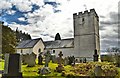
Early Medieval (Dark Age)Site Name: Defynnog StoneCountry: Wales County: Powys Type: Early Christian Sculptured Stone
Nearest Town: Brecon Nearest Village: Defynnog
Map Ref: SN92532793
Latitude: 51.939461N Longitude: 3.564765W
Condition:
| 5 | Perfect |
| 4 | Almost Perfect |
| 3 | Reasonable but with some damage |
| 2 | Ruined but still recognisable as an ancient site |
| 1 | Pretty much destroyed, possibly visible as crop marks |
| 0 | No data. |
| -1 | Completely destroyed |
| 5 | Superb |
| 4 | Good |
| 3 | Ordinary |
| 2 | Not Good |
| 1 | Awful |
| 0 | No data. |
| 5 | Can be driven to, probably with disabled access |
| 4 | Short walk on a footpath |
| 3 | Requiring a bit more of a walk |
| 2 | A long walk |
| 1 | In the middle of nowhere, a nightmare to find |
| 0 | No data. |
| 5 | co-ordinates taken by GPS or official recorded co-ordinates |
| 4 | co-ordinates scaled from a detailed map |
| 3 | co-ordinates scaled from a bad map |
| 2 | co-ordinates of the nearest village |
| 1 | co-ordinates of the nearest town |
| 0 | no data |
Internal Links:
External Links:
I have visited· I would like to visit
NickyD visited on 1st Jan 2016 - their rating: Cond: 3 Amb: 3 Access: 5
coin visited Beautiful day to visit with two low-flying red kites above the ancient graveyard. Nice cross too.
")
The stone was later reused when a cross was inscribed into it in the 7th - 9th Century.
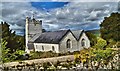
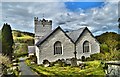
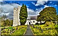
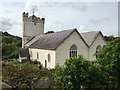
In the fourteenth Century the stone was used in the wall of the church tower of St Cynog, Defynnog. In recent times the stone as been moved to the church porch, where the base or first letter of the inscription have been set in concrete!
As viewed in the church porch the ogham inscription is down the left side of the stone, most of the inscription has been removed by later masons.
More at www.cofiadurcahcymru.org.uk/arch/query/page.php?watprn=CPAT574
You may be viewing yesterday's version of this page. To see the most up to date information please register for a free account.
")
Do not use the above information on other web sites or publications without permission of the contributor.
Nearby Images from Geograph Britain and Ireland:
©2015(licence)
©2015(licence)
©2015(licence)
©2018(licence)
©2015(licence)
The above images may not be of the site on this page, they are loaded from Geograph.
Please Submit an Image of this site or go out and take one for us!
Click here to see more info for this site
Nearby sites
Key: Red: member's photo, Blue: 3rd party photo, Yellow: other image, Green: no photo - please go there and take one, Grey: site destroyed
Download sites to:
KML (Google Earth)
GPX (GPS waypoints)
CSV (Garmin/Navman)
CSV (Excel)
To unlock full downloads you need to sign up as a Contributory Member. Otherwise downloads are limited to 50 sites.
Turn off the page maps and other distractions
Nearby sites listing. In the following links * = Image available
1.6km N 2° Coed Gibraltar* Promontory Fort / Cliff Castle (SN92622954)
1.7km S 188° Twyn y Gaer (Defynnog)* Hillfort (SN92252630)
1.7km S 190° Twyn-y-Gaer (Heol Senni) Hillfort (SN922263)
2.4km SE 145° Tyle Bychan* Standing Stones (SN93872595)
3.7km ESE 122° Blaen Camlais Standing Stones* Standing Stones (SN9560525889)
4.4km ENE 66° St David's Church (Trallong)* Early Christian Sculptured Stone (SN966296)
4.5km ESE 122° Mynydd Illtud Standing Stone 2* Standing Stone (Menhir) (SN963255)
5.2km ENE 58° Twyn-y-Gaer (Trallong)* Hillfort (SN970306)
5.3km ESE 104° Mynydd Illtud Standing Stone 1* Standing Stone (Menhir) (SN97602651)
5.6km WNW 297° Varlen Cairn* Cairn (SN87643060)
5.8km SSW 201° Nant Cnewr-Fawr Cairn* Cairn (SN9030022608)
5.9km SSW 200° Nant Cnewr-Fawr Stone* Standing Stone (Menhir) (SN9034122432)
6.0km WNW 290° St David's Church, Llywel* Marker Stone (SN86953005)
6.1km W 281° Tyle Mawr* Cairn (SN86542920)
6.5km E 88° Twyn-y-Gaer (Llanspyddid)* Hillfort (SN990280)
6.9km ENE 66° Aberyscir* Ring Cairn (SN98883057)
6.9km SSE 154° Craig Cwn Ddu cairns* Cairn (SN95452170)
7.0km N 359° Gwar-y-Felin Ring Cairn (SN925349)
7.2km SE 140° Rock art near Craig Cerrig Gleisiad* Rock Art (SN9697822316)
7.5km WNW 299° Blaen Clydach Fach Cairn 1* Cairn (SN86043170)
7.6km SE 139° Blaenglyn* Cairn (SN974221)
7.6km WNW 300° Blaen Clydach Fach Cairn 2* Cairn (SN86003185)
8.2km WNW 284° Pant Madog Cairn* Round Barrow(s) (SN84623003)
8.5km ENE 70° Battle (Powys)* Standing Stone (Menhir) (SO0062730638)
8.6km SW 231° Bwlch Cerrig Duon Cist east* Cairn (SN85682272)
View more nearby sites and additional images


 We would like to know more about this location. Please feel free to add a brief description and any relevant information in your own language.
 Wir möchten mehr über diese Stätte erfahren. Bitte zögern Sie nicht, eine kurze Beschreibung und relevante Informationen in Deutsch hinzuzufügen.
 Nous aimerions en savoir encore un peu sur les lieux. S'il vous plaît n'hesitez pas à ajouter une courte description et tous les renseignements pertinents dans votre propre langue.
 Quisieramos informarnos un poco más de las lugares. No dude en añadir una breve descripción y otros datos relevantes en su propio idioma.