


<< Our Photo Pages >> Gorllwyn - Cairn in Wales in Powys
Submitted by cerrig on Tuesday, 11 September 2012 Page Views: 4085
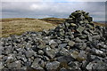
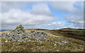
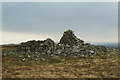
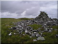
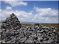
Neolithic and Bronze AgeSite Name: GorllwynCountry: Wales County: Powys Type: Cairn
Nearest Town: Rhayader Nearest Village: Llanwrthll
Map Ref: SN9159858800
Latitude: 52.216720N Longitude: 3.58813W
Condition:
| 5 | Perfect |
| 4 | Almost Perfect |
| 3 | Reasonable but with some damage |
| 2 | Ruined but still recognisable as an ancient site |
| 1 | Pretty much destroyed, possibly visible as crop marks |
| 0 | No data. |
| -1 | Completely destroyed |
| 5 | Superb |
| 4 | Good |
| 3 | Ordinary |
| 2 | Not Good |
| 1 | Awful |
| 0 | No data. |
| 5 | Can be driven to, probably with disabled access |
| 4 | Short walk on a footpath |
| 3 | Requiring a bit more of a walk |
| 2 | A long walk |
| 1 | In the middle of nowhere, a nightmare to find |
| 0 | No data. |
| 5 | co-ordinates taken by GPS or official recorded co-ordinates |
| 4 | co-ordinates scaled from a detailed map |
| 3 | co-ordinates scaled from a bad map |
| 2 | co-ordinates of the nearest village |
| 1 | co-ordinates of the nearest town |
| 0 | no data |
Internal Links:
External Links:
")
Long distance Panoramic views all around, making the arduous walk in worthwhile, but come on a nice day, and come prepared. There are no short cuts to this site.
You may be viewing yesterday's version of this page. To see the most up to date information please register for a free account.
")
")
")
Do not use the above information on other web sites or publications without permission of the contributor.
Nearby Images from Geograph Britain and Ireland:
©2007(licence)
©2010(licence)
©2011(licence)
©2010(licence)
©2015(licence)
The above images may not be of the site on this page, they are loaded from Geograph.
Please Submit an Image of this site or go out and take one for us!
Click here to see more info for this site
Nearby sites
Key: Red: member's photo, Blue: 3rd party photo, Yellow: other image, Green: no photo - please go there and take one, Grey: site destroyed
Download sites to:
KML (Google Earth)
GPX (GPS waypoints)
CSV (Garmin/Navman)
CSV (Excel)
To unlock full downloads you need to sign up as a Contributory Member. Otherwise downloads are limited to 50 sites.
Turn off the page maps and other distractions
Nearby sites listing. In the following links * = Image available
1.2km SE 143° Gurnos Cairn* Cairn (SN92275786)
1.2km SE 142° Gurnos Ring Cairn* Cairn (SN9229157866)
1.6km NNW 328° Llwydnant Cairn 1* Cairn (SN9079860131)
1.6km NNW 333° Llwydnant Cairn II* Cairn (SN9090560238)
1.6km W 261° Bwlch-y-Ddau-Faen Cairn* Cairn (SN90015859)
2.3km S 191° Darren Standing Stones* Standing Stones (SN91125658)
2.6km NW 314° Esgair Ceiliog* Ring Cairn (SN8977060636)
3.0km N 4° Garn Lwyd Cairn* Ring Cairn (SN919618)
3.1km NW 305° Esgair Hafod* Ring Cairn (SN891606)
3.2km NNE 26° Waun Sarn Cairn* Cairn (SN93066161)
3.4km N 9° Gro Hill Cairn 6* Cairn (SN922621)
3.4km NNE 14° Gro Hill Cairn 4* Cairn (SN925621)
3.4km NNE 16° Gro Hill Cairn 5* Cairn (SN926621)
3.5km N 9° Gro Hill Cairn 8* Cairn (SN922622)
3.6km NNE 15° Gro Hill Cairn 2* Cairn (SN92636227)
3.6km NNE 15° Gro Hill Cist* Cist (SN926623)
3.6km ENE 64° Saith Maen WSW* Stone Row / Alignment (SN9492160315)
3.7km NNE 16° Gro Hill Cairns* Cairn (SN927623)
3.7km S 187° Lednant Round Barrow* Cairn (SN91045517)
3.7km NE 45° y Gamriw 1* Ring Cairn (SN943614)
3.7km N 8° Gro Hill Cairn 7* Cairn (SN922625)
3.8km S 187° Hen Clawdd Stones* Standing Stones (SN9106155036)
3.9km NNE 20° Crugian Bach prehistoric monument complex* Barrow Cemetery (SN930624)
3.9km NW 307° Rhiwnant Prehistoric Ancient Settlement* Ancient Village or Settlement (SN88556119)
3.9km NW 310° Craig Rhiwnant Cairns 2* Cairn (SN8865661340)
View more nearby sites and additional images


 We would like to know more about this location. Please feel free to add a brief description and any relevant information in your own language.
 Wir möchten mehr über diese Stätte erfahren. Bitte zögern Sie nicht, eine kurze Beschreibung und relevante Informationen in Deutsch hinzuzufügen.
 Nous aimerions en savoir encore un peu sur les lieux. S'il vous plaît n'hesitez pas à ajouter une courte description et tous les renseignements pertinents dans votre propre langue.
 Quisieramos informarnos un poco más de las lugares. No dude en añadir una breve descripción y otros datos relevantes en su propio idioma.