


<< Our Photo Pages >> Rowbarrow Group - Barrow Cemetery in England in Somerset
Submitted by sem on Saturday, 08 July 2017 Page Views: 1669
Neolithic and Bronze AgeSite Name: Rowbarrow GroupCountry: England County: Somerset Type: Barrow Cemetery
Nearest Town: Porlock Nearest Village: Wheddon Cross
Map Ref: SS87544154
Latitude: 51.162020N Longitude: 3.609674W
Condition:
| 5 | Perfect |
| 4 | Almost Perfect |
| 3 | Reasonable but with some damage |
| 2 | Ruined but still recognisable as an ancient site |
| 1 | Pretty much destroyed, possibly visible as crop marks |
| 0 | No data. |
| -1 | Completely destroyed |
| 5 | Superb |
| 4 | Good |
| 3 | Ordinary |
| 2 | Not Good |
| 1 | Awful |
| 0 | No data. |
| 5 | Can be driven to, probably with disabled access |
| 4 | Short walk on a footpath |
| 3 | Requiring a bit more of a walk |
| 2 | A long walk |
| 1 | In the middle of nowhere, a nightmare to find |
| 0 | No data. |
| 5 | co-ordinates taken by GPS or official recorded co-ordinates |
| 4 | co-ordinates scaled from a detailed map |
| 3 | co-ordinates scaled from a bad map |
| 2 | co-ordinates of the nearest village |
| 1 | co-ordinates of the nearest town |
| 0 | no data |
Internal Links:
External Links:
I have visited· I would like to visit
sem has visited here
")
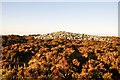
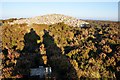
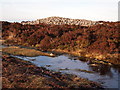
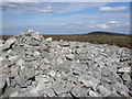
Taken from www.exmoorher.co.uk - "Scheduled Monument 1003677: Group of four barrows and cairns known as 'Rowbarrows' including Great Rowbarrow and Little Rowbarrow".
For more information see Exmoor National Park Website MS09185 (Scheduled Monument 1003677).
You may be viewing yesterday's version of this page. To see the most up to date information please register for a free account.
")
")
")
Do not use the above information on other web sites or publications without permission of the contributor.
Nearby Images from Geograph Britain and Ireland:
©2011(licence)
©2011(licence)
©2012(licence)
©2011(licence)

©2005(licence)
The above images may not be of the site on this page, they are loaded from Geograph.
Please Submit an Image of this site or go out and take one for us!
Click here to see more info for this site
Nearby sites
Key: Red: member's photo, Blue: 3rd party photo, Yellow: other image, Green: no photo - please go there and take one, Grey: site destroyed
Download sites to:
KML (Google Earth)
GPX (GPS waypoints)
CSV (Garmin/Navman)
CSV (Excel)
To unlock full downloads you need to sign up as a Contributory Member. Otherwise downloads are limited to 50 sites.
Turn off the page maps and other distractions
Nearby sites listing. In the following links * = Image available
928m ESE 117° Codsend Moor Multiple Stone Rows / Avenue (SS88364110)
1.4km WSW 249° Hoar Moor (E)* Standing Stone (Menhir) (SS86214106)
1.7km E 87° Dunkery Beacon* Barrow Cemetery (SS892416)
1.7km NE 55° Sweetworthy settlement* Ancient Village or Settlement (SS890425)
1.9km WSW 244° Hoar Moor (W) Standing Stone (Menhir) (SS85864075)
1.9km WNW 282° Wilmersham Common South* Multiple Stone Rows / Avenue (SS85664197)
2.0km WNW 286° Wilmersham Common North* Stone Row / Alignment (SS8561242129)
3.2km W 272° Almsworthy* Stone Circle (SS8430941698)
3.4km ENE 68° Robin How* Cairn (SS90764273)
3.5km ENE 68° Joaney How Cairn (SS90814279)
3.7km NNW 333° Berry Castle (Exmoor) Hillfort (SS859449)
3.9km W 280° Alderman's Barrow* Round Barrow(s) (SS837423)
4.3km NW 315° Porlock Common SW* Multiple Stone Rows / Avenue (SS8457544654)
4.3km NW 315° Porlock Circle* Stone Circle (SS84514467)
4.5km NW 308° Coley Water, South* Stone Row / Alignment (SS84074438)
4.5km W 281° Madacombe* Stone Row / Alignment (SS831425)
4.6km WNW 282° Madacombe Barrows Barrow Cemetery (SS830426)
4.7km NW 311° Porlock Allotment NE* Standing Stones (SS84014471)
4.7km WNW 297° Porlock Allotment SW* Multiple Stone Rows / Avenue (SS8335543785)
5.0km WNW 297° Hoscombe SE* Stone Row / Alignment (SS8311443876)
5.2km WNW 298° Hoscombe NW Standing Stones (SS830441)
5.2km NNW 334° Whit Stones* Standing Stones (SS8532846255)
5.3km W 263° Larkbarrow Corner Stone Setting* Standing Stones (SS82224097)
5.4km W 262° Wester Mill Multiple Stone Rows / Avenue (SS822409)
5.5km W 265° Larkbarrow Corner Standing Stone* Standing Stone (Menhir) (SS82084116)
View more nearby sites and additional images


 We would like to know more about this location. Please feel free to add a brief description and any relevant information in your own language.
 Wir möchten mehr über diese Stätte erfahren. Bitte zögern Sie nicht, eine kurze Beschreibung und relevante Informationen in Deutsch hinzuzufügen.
 Nous aimerions en savoir encore un peu sur les lieux. S'il vous plaît n'hesitez pas à ajouter une courte description et tous les renseignements pertinents dans votre propre langue.
 Quisieramos informarnos un poco más de las lugares. No dude en añadir una breve descripción y otros datos relevantes en su propio idioma.