


<< Our Photo Pages >> Logie Old Kirk (Stirling) - Early Christian Sculptured Stone in Scotland in Stirling
Submitted by Anne T on Monday, 09 October 2017 Page Views: 2787
Early Medieval (Dark Age)Site Name: Logie Old Kirk (Stirling)Country: Scotland County: Stirling Type: Early Christian Sculptured Stone
Nearest Town: Stirling
Map Ref: NS81549696
Latitude: 56.150567N Longitude: 3.90846W
Condition:
| 5 | Perfect |
| 4 | Almost Perfect |
| 3 | Reasonable but with some damage |
| 2 | Ruined but still recognisable as an ancient site |
| 1 | Pretty much destroyed, possibly visible as crop marks |
| 0 | No data. |
| -1 | Completely destroyed |
| 5 | Superb |
| 4 | Good |
| 3 | Ordinary |
| 2 | Not Good |
| 1 | Awful |
| 0 | No data. |
| 5 | Can be driven to, probably with disabled access |
| 4 | Short walk on a footpath |
| 3 | Requiring a bit more of a walk |
| 2 | A long walk |
| 1 | In the middle of nowhere, a nightmare to find |
| 0 | No data. |
| 5 | co-ordinates taken by GPS or official recorded co-ordinates |
| 4 | co-ordinates scaled from a detailed map |
| 3 | co-ordinates scaled from a bad map |
| 2 | co-ordinates of the nearest village |
| 1 | co-ordinates of the nearest town |
| 0 | no data |
Internal Links:
External Links:
I have visited· I would like to visit
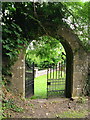
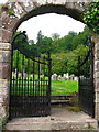
Anne T visited on 26th Sep 2017 - their rating: Cond: 3 Amb: 4 Access: 4 Hogbacks at Logie Old Kirk, Stirling: To reach the church from the University Halls of Residence, we had to walk through the gardener’s compound/offices. The top two gates around the churchyard were locked; the actual entrance was next to the small stone building to the south of the churchyard, near the stream, with an information board by a small car park, so there is access from the main road.
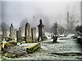
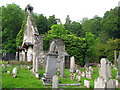
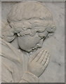
The churchyard is full of wonderful (morbid!) tombstones. Could have spent the day photographing them. It was also a lovely location with a small stream trickling along the eastern side of the churchyard.
Found one hogback SE of the church, the second is just a lump at the end (by the church) of the 6th row of graves, counting from the stream at the east end of the churchyard. A wonderful location. Really could have spent hours here.
 (PID:172135)")
In the churchyard of Old Logie Kirk can be found one complete hogback and one fragment, both early medieval. The kirk, now a ruin, was built in around 1560, and forms part of a Kirkyard Trail. The churchyard is roughly oval in shape with a stream (the Logie burn) running along its eastern boundary.
Recorded as Canmore ID 47165, which tells us: "A hog-backed tombstone lies in the graveyard, SE of the Old Logie church. It is 5'8" long and tapers, at ground level, from a breadth of 14 1/2" at the head to 8" at the foot. The N side shows traces of ornamentation representing tiles. Another hog-back was turned out of the graveyard about 1907, and a fragment of it, found and replaced in 1927, is probably the rounded lump now set as a headstone at the N end of the sixth row of tombstones. There are also nearly a hundred stones dated before 1707, mostly falling in the last quarter of the 17th century in the graveyard." These fascinating tombstones carved with symbols of trades and mortality.
The kirk lies just to the north east of Stirling University Student's Union Community, which can be reached by road off the B998. To get to the actual church from the nearby Airthrey Castle Standing Stone requires walking through the grounds of the gardening maintenance contractors; if driving, there is a small side road which leads to the south of this churchyard, which branches off to Logie and Carlie Cottages, which lie to the east of the kirk. There is a small parking area to the south of the church, by the main access into the churchyard, with an information board.
You may be viewing yesterday's version of this page. To see the most up to date information please register for a free account.
 (PID:172134)")
 (PID:172138)")
 (PID:172137)")
 (PID:172136)")
Do not use the above information on other web sites or publications without permission of the contributor.
Nearby Images from Geograph Britain and Ireland:
©2009(licence)
©2007(licence)
©2007(licence)
©2007(licence)
©2007(licence)
The above images may not be of the site on this page, they are loaded from Geograph.
Please Submit an Image of this site or go out and take one for us!
Click here to see more info for this site
Nearby sites
Key: Red: member's photo, Blue: 3rd party photo, Yellow: other image, Green: no photo - please go there and take one, Grey: site destroyed
Download sites to:
KML (Google Earth)
GPX (GPS waypoints)
CSV (Garmin/Navman)
CSV (Excel)
To unlock full downloads you need to sign up as a Contributory Member. Otherwise downloads are limited to 50 sites.
Turn off the page maps and other distractions
Nearby sites listing. In the following links * = Image available
374m SSW 198° The Victoria Stone* Marker Stone (NS8141296608)
480m SSW 195° Airthrey Stone* Standing Stone (Menhir) (NS81409650)
937m W 263° Pathfoot Stone* Standing Stone (Menhir) (NS8060496871)
1.1km NNW 348° Fairy Well (Logie)* Holy Well or Sacred Spring (NS81359804)
1.4km SSW 203° Abbey Craig Vitrified Fort* Hillfort (NS80949565)
1.5km W 277° Lentran (Bridge of Allan) Cist (NS80039720)
1.6km SW 220° Bel Stane (Causewayhead) Standing Stone (Menhir) (NS805958)
2.3km N 351° Pendreich 3 (Bridge of Allan) Cairn (NS81259922)
2.3km WNW 301° Fairy Knowe (Bridge of Allan)* Cairn (NS79619818)
2.3km N 351° Pendreich 1 (Bridge of Allan) Cairn (NS8124499236)
2.4km NNW 348° Split Stone (Bridge of Allan) Standing Stone (Menhir) (NS8111699311)
2.4km N 351° Pendreich 2 (Bridge of Allan) Cairn (NS81239938)
2.4km NNW 332° Cuparlaw Wood (Bridge of Allan) Cairn (NS80469916)
2.7km N 355° The Great Stane O' Pendreigh* Standing Stone (Menhir) (NS8138299686)
3.3km SW 221° Our Lady's Well (Stirling) Holy Well or Sacred Spring (NS79329454)
4.0km SW 219° Butt Well* Holy Well or Sacred Spring (NS78949389)
4.3km ESE 108° Lady's Well (Tullibody) Holy Well or Sacred Spring (NS85639548)
4.4km SSW 203° St Ninian's Well (Stirling)* Holy Well or Sacred Spring (NS7969093012)
4.6km NW 315° Kippenross House (Dunblane) Cairn (NN78370036)
4.7km ESE 117° Haer Stane* Standing Stone (Menhir) (NS85659475)
4.8km ESE 108° The Maiden Stone (Tullibody)* Sculptured Stone (NS86039533)
4.8km ESE 108° Priest's Well (Tullibody) Holy Well or Sacred Spring (NS8606995324)
4.9km SSW 199° Wester Livilands* Broch or Nuraghe (NS7979692369)
5.0km SSW 203° Randolphfield Stones* Standing Stones (NS79449244)
5.1km SW 217° King's Park Cup and Rings* Rock Art (NS7837892998)
View more nearby sites and additional images


 We would like to know more about this location. Please feel free to add a brief description and any relevant information in your own language.
 Wir möchten mehr über diese Stätte erfahren. Bitte zögern Sie nicht, eine kurze Beschreibung und relevante Informationen in Deutsch hinzuzufügen.
 Nous aimerions en savoir encore un peu sur les lieux. S'il vous plaît n'hesitez pas à ajouter une courte description et tous les renseignements pertinents dans votre propre langue.
 Quisieramos informarnos un poco más de las lugares. No dude en añadir una breve descripción y otros datos relevantes en su propio idioma.