


<< Our Photo Pages >> West Skelston White Cairn - Cairn in Scotland in Dumfries and Galloway
Submitted by markj99 on Thursday, 09 April 2020 Page Views: 735
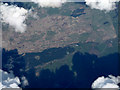
Neolithic and Bronze AgeSite Name: West Skelston White CairnCountry: Scotland County: Dumfries and Galloway Type: Cairn
Nearest Town: Dumfries Nearest Village: Dunscore
Map Ref: NX82358551
Latitude: 55.149902N Longitude: 3.84767W
Condition:
| 5 | Perfect |
| 4 | Almost Perfect |
| 3 | Reasonable but with some damage |
| 2 | Ruined but still recognisable as an ancient site |
| 1 | Pretty much destroyed, possibly visible as crop marks |
| 0 | No data. |
| -1 | Completely destroyed |
| 5 | Superb |
| 4 | Good |
| 3 | Ordinary |
| 2 | Not Good |
| 1 | Awful |
| 0 | No data. |
| 5 | Can be driven to, probably with disabled access |
| 4 | Short walk on a footpath |
| 3 | Requiring a bit more of a walk |
| 2 | A long walk |
| 1 | In the middle of nowhere, a nightmare to find |
| 0 | No data. |
| 5 | co-ordinates taken by GPS or official recorded co-ordinates |
| 4 | co-ordinates scaled from a detailed map |
| 3 | co-ordinates scaled from a bad map |
| 2 | co-ordinates of the nearest village |
| 1 | co-ordinates of the nearest town |
| 0 | no data |
Internal Links:
External Links:
")
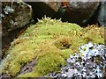
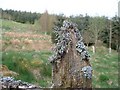
Canmore ID 65098 describes the cairn in 1991 as follows: "This cairn is situated on the crest of a spur and measures 23m in diameter and 3m in height; it has been partly robbed and has been supplemented by large boulders relatively recently."
There are original stones with an aged white patina but there are also a large central robbed out void, large field clearance stones and some old farm equipment on this cairn.
This seems to be the fate of cairns in proximity of farms where the temptation to exploit a natural resource is too great.
You may be viewing yesterday's version of this page. To see the most up to date information please register for a free account.
")
")
Do not use the above information on other web sites or publications without permission of the contributor.
Nearby Images from Geograph Britain and Ireland:

©2005(licence)
©2017(licence)
©2009(licence)
©2009(licence)
©2009(licence)
The above images may not be of the site on this page, they are loaded from Geograph.
Please Submit an Image of this site or go out and take one for us!
Click here to see more info for this site
Nearby sites
Key: Red: member's photo, Blue: 3rd party photo, Yellow: other image, Green: no photo - please go there and take one, Grey: site destroyed
Download sites to:
KML (Google Earth)
GPX (GPS waypoints)
CSV (Garmin/Navman)
CSV (Excel)
To unlock full downloads you need to sign up as a Contributory Member. Otherwise downloads are limited to 50 sites.
Turn off the page maps and other distractions
Nearby sites listing. In the following links * = Image available
1.6km SE 135° Glenesslin Schoolhouse* Cairn (NX83488433)
3.0km ESE 104° White Cairn, Gilmerston Cairn (NX853847)
3.6km ENE 58° Fleuchlarg White Cairn* Chambered Cairn (NX85438734)
4.6km NNW 341° Glencairn Cursus Cursus (NX80948993)
7.2km E 98° Springfield Hill Hillfort (NX89448431)
7.2km N 10° Capenoch Cairn (NX8385092608)
7.9km W 276° Physic Well (Balmaclellan) Holy Well or Sacred Spring (NX7452586502)
8.4km N 356° Tynron Doon* Hillfort (NX8197093927)
8.8km NE 53° Kirkpatrick Hill (Closeburn) Holy Well or Sacred Spring (NX896906)
9.2km SE 146° Angel Well (Barnsoul) Holy Well or Sacred Spring (NX87337770)
9.5km E 90° Temple Wood (Dunscore)* Modern Stone Circle etc (NX91848522)
9.6km N 360° Grennan Hill Hillfort (NX82549507)
9.6km NE 54° My Lady's Well (Brownhill) Holy Well or Sacred Spring (NX90279100)
9.7km SSE 150° The Doons* Hillfort (NX86987699)
9.9km W 277° Hole Stone (Blackmark)* Standing Stone (Menhir) (NX72568698)
10.0km NNE 31° Templand Mains* Standing Stone (Menhir) (NX87719396)
10.2km SE 125° Hall Hill* Hillfort (NX90597949)
10.7km ESE 119° Holywood Cursus Cursus (NX91558004)
10.9km NNE 23° Nith Bridge Cross* Ancient Cross (NX8689095471)
11.8km NNE 19° Penpont Cursus Cursus (NX86409658)
11.8km NW 323° St. Conal's Well* Holy Well or Sacred Spring (NX75399508)
12.0km N 359° Honeyhole White Cairn* Cairn (NX82389757)
12.2km W 267° Spa Well (Dalry) Holy Well or Sacred Spring (NX7009385098)
12.8km SE 134° Beacon Hill (Dumfries and Galloway)* Hillfort (NX91397643)
13.1km SE 126° Ladye Well (Terregles) Holy Well or Sacred Spring (NX92767744)
View more nearby sites and additional images


 We would like to know more about this location. Please feel free to add a brief description and any relevant information in your own language.
 Wir möchten mehr über diese Stätte erfahren. Bitte zögern Sie nicht, eine kurze Beschreibung und relevante Informationen in Deutsch hinzuzufügen.
 Nous aimerions en savoir encore un peu sur les lieux. S'il vous plaît n'hesitez pas à ajouter une courte description et tous les renseignements pertinents dans votre propre langue.
 Quisieramos informarnos un poco más de las lugares. No dude en añadir una breve descripción y otros datos relevantes en su propio idioma.