

<< Our Photo Pages >> St Tudno's Cradle - Natural Stone / Erratic / Other Natural Feature in Wales in Conwy
Submitted by TimPrevett on Wednesday, 28 July 2021 Page Views: 996
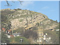
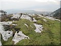
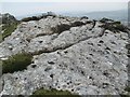
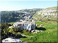
Natural PlacesSite Name: St Tudno's Cradle Alternative Name: Maen Sigl, The Judgement StoneCountry: Wales County: Conwy Type: Natural Stone / Erratic / Other Natural Feature
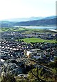
Nearest Town: Llandudno
Map Ref: SH779829
Latitude: 53.328885N Longitude: 3.83485W
Condition:
| 5 | Perfect |
| 4 | Almost Perfect |
| 3 | Reasonable but with some damage |
| 2 | Ruined but still recognisable as an ancient site |
| 1 | Pretty much destroyed, possibly visible as crop marks |
| 0 | No data. |
| -1 | Completely destroyed |
| 5 | Superb |
| 4 | Good |
| 3 | Ordinary |
| 2 | Not Good |
| 1 | Awful |
| 0 | No data. |
| 5 | Can be driven to, probably with disabled access |
| 4 | Short walk on a footpath |
| 3 | Requiring a bit more of a walk |
| 2 | A long walk |
| 1 | In the middle of nowhere, a nightmare to find |
| 0 | No data. |
| 5 | co-ordinates taken by GPS or official recorded co-ordinates |
| 4 | co-ordinates scaled from a detailed map |
| 3 | co-ordinates scaled from a bad map |
| 2 | co-ordinates of the nearest village |
| 1 | co-ordinates of the nearest town |
| 0 | no data |
Internal Links:
External Links:
")
Access via a footpath from the north, from the car park next to the dry ski slope.
You may be viewing yesterday's version of this page. To see the most up to date information please register for a free account.
")
")
")
Do not use the above information on other web sites or publications without permission of the contributor.
Nearby Images from Geograph Britain and Ireland:
©2007(licence)
©2017(licence)
©2017(licence)
©2014(licence)
©2010(licence)
The above images may not be of the site on this page, they are loaded from Geograph.
Please Submit an Image of this site or go out and take one for us!
Click here to see more info for this site
Nearby sites
Key: Red: member's photo, Blue: 3rd party photo, Yellow: other image, Green: no photo - please go there and take one, Grey: site destroyed
Download sites to:
KML (Google Earth)
GPX (GPS waypoints)
CSV (Garmin/Navman)
CSV (Excel)
To unlock full downloads you need to sign up as a Contributory Member. Otherwise downloads are limited to 50 sites.
Turn off the page maps and other distractions
Nearby sites listing. In the following links * = Image available
100m N 358° Pen-y-Dinas (Conwy)* Hillfort (SH779830)
113m SE 133° Upper Kendrick's Cave* Cave or Rock Shelter (SH7798182821)
141m SE 134° Lower Kendrick's Cave Cave or Rock Shelter (SH780828)
305m ENE 60° Llandudno Eisteddfod Circle* Modern Stone Circle etc (SH7816883048)
412m NNW 345° Great Orme Lost Chamber* Burial Chamber or Dolmen (SH778833)
510m SSE 167° Llandudno Museum* Museum (SH78008240)
687m W 273° Lletty'r Filiast* Burial Chamber or Dolmen (SH7721382950)
798m W 269° Great Orme barrow* Round Barrow(s) (SH771829)
845m WNW 282° Great Orme Mine* Ancient Mine, Quarry or other Industry (SH7707683100)
1.1km WNW 299° Brynia Poethion Ancient Village or Settlement (SH76998343)
1.2km NW 315° St Tudno's Well* Holy Well or Sacred Spring (SH77068378)
1.4km W 277° Bishop's Quarries Hut Circle Ancient Village or Settlement (SH76498311)
1.6km WNW 303° Ffynnon Rufeinig* Holy Well or Sacred Spring (SH766838)
1.8km NW 310° Hwylfa’r Ceirw Stone Alignment* Stone Row / Alignment (SH76568409)
1.9km NW 307° Hafnant Ancient Village or Settlement (SH76398409)
2.4km WNW 285° Great Orme Head cairn* Cairn (SH75618357)
2.4km ESE 121° Ogof Tan-Y-Bryn Cave or Rock Shelter (SH79948160)
2.9km SE 132° Coed Gaer Hut Circle* Ancient Village or Settlement (SH80028092)
2.9km SSE 152° Ffynnon Santes Fair Holy Well or Sacred Spring (SH792803)
2.9km SSE 150° Llanrhos church Inscribed Stone Early Christian Sculptured Stone (SH79338032)
3.2km ESE 112° Ogof Pant-Y-Wennol Cave Cave or Rock Shelter (SH80818161)
3.5km S 173° Deganwy Castle* Ancient Village or Settlement (SH7822579455)
3.6km E 92° Ogof Rhiwleden Cave or Rock Shelter (SH81538269)
4.2km SSE 152° Bodysgallen* Hillfort (SH798791)
5.4km SSW 199° Conway Mountain* Hillfort (SH760778)
View more nearby sites and additional images


 We would like to know more about this location. Please feel free to add a brief description and any relevant information in your own language.
 Wir möchten mehr über diese Stätte erfahren. Bitte zögern Sie nicht, eine kurze Beschreibung und relevante Informationen in Deutsch hinzuzufügen.
 Nous aimerions en savoir encore un peu sur les lieux. S'il vous plaît n'hesitez pas à ajouter une courte description et tous les renseignements pertinents dans votre propre langue.
 Quisieramos informarnos un poco más de las lugares. No dude en añadir una breve descripción y otros datos relevantes en su propio idioma.