


<< Our Photo Pages >> Chains Barrow - Round Barrow(s) in England in Somerset
Submitted by JohnE on Thursday, 04 April 2024 Page Views: 29
Neolithic and Bronze AgeSite Name: Chains BarrowCountry: England
NOTE: This site is 0.8 km away from the location you searched for.
County: Somerset Type: Round Barrow(s)
Nearest Town: Lynton Nearest Village: Simonsbath
Map Ref: SS73464190
Latitude: 51.162312N Longitude: 3.811057W
Condition:
| 5 | Perfect |
| 4 | Almost Perfect |
| 3 | Reasonable but with some damage |
| 2 | Ruined but still recognisable as an ancient site |
| 1 | Pretty much destroyed, possibly visible as crop marks |
| 0 | No data. |
| -1 | Completely destroyed |
| 5 | Superb |
| 4 | Good |
| 3 | Ordinary |
| 2 | Not Good |
| 1 | Awful |
| 0 | No data. |
| 5 | Can be driven to, probably with disabled access |
| 4 | Short walk on a footpath |
| 3 | Requiring a bit more of a walk |
| 2 | A long walk |
| 1 | In the middle of nowhere, a nightmare to find |
| 0 | No data. |
| 5 | co-ordinates taken by GPS or official recorded co-ordinates |
| 4 | co-ordinates scaled from a detailed map |
| 3 | co-ordinates scaled from a bad map |
| 2 | co-ordinates of the nearest village |
| 1 | co-ordinates of the nearest town |
| 0 | no data |
Internal Links:
External Links:
")
According to Historic England:
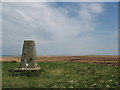
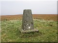
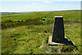
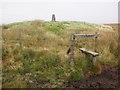
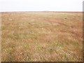
"The barrow survives as a circular stone and earth-built mound measuring approximately 25m in diameter and 1.7m high. A surrounding quarry ditch, from which the construction material was derived, is visible as a partially buried 2m wide and 0.2m deep feature. A triangulation pillar has been placed on the summit of the mound."
It is a bit of a hike to reach it, but well worth the effort. At 487m, it is one of the highest points on the western moor and the views are extensive: east to Dunkery Beacon and south to Five Barrows Hill. From here, you can see why it is called Five Barrows Hill, even though there are at least nine. It is an atmospheric place, either on a warm summer’s morning with the sound of skylarks and a wide blue sky above, or, as is more often the case, when it is grey, wet and windy, making you feel at one with the moor’s bleak landscape and the surrounding prehistoric features.
For a circular walk of just under four miles, park in the layby on the B3358 at Goat Hill Bridge (SS72454040). Follow the path past the Pinkery Centre up onto the moor to reach the forlorn-looking Pinkery Pond and then turn right along the Tarka Trail. At the junction with the Macmillan Way West (SS73224177), ascend north east over rough terrain to reach the trig point on the barrow. To return, follow the Macmillan Way downhill to the road, where you turn right and follow it back to the layby. Warning: don’t deviate too far from the paths as it is very boggy.
More at: Historic England
You may be viewing yesterday's version of this page. To see the most up to date information please register for a free account.
")
Do not use the above information on other web sites or publications without permission of the contributor.
Nearby Images from Geograph Britain and Ireland:
©2011(licence)
©2013(licence)
©2017(licence)
©2013(licence)
©2013(licence)
The above images may not be of the site on this page, they are loaded from Geograph.
Please Submit an Image of this site or go out and take one for us!
Click here to see more info for this site
Nearby sites
Key: Red: member's photo, Blue: 3rd party photo, Yellow: other image, Green: no photo - please go there and take one, Grey: site destroyed
Download sites to:
KML (Google Earth)
GPX (GPS waypoints)
CSV (Garmin/Navman)
CSV (Excel)
To unlock full downloads you need to sign up as a Contributory Member. Otherwise downloads are limited to 50 sites.
Turn off the page maps and other distractions
Nearby sites listing. In the following links * = Image available
843m E 82° Long Chains Coombe SW Standing Stones (SS743420)
1.1km ENE 67° Long Chains Coombe NE Multiple Stone Rows / Avenue (SS745423)
1.5km E 94° Chains Valley* Stone Row / Alignment (SS7491541775)
1.6km SW 225° Bill Hill (Somerset) Standing Stones (SS723408)
1.7km NNW 335° Benjamy* Stone Row / Alignment (SS72804344)
1.7km ENE 63° Hoaroak stones* Standing Stones (SS74984263)
1.9km NE 55° Cheriton Ridge Boundary stones* Modern Stone Circle etc (SS75054295)
1.9km WNW 287° Woodbarrow (Exmoor)* Round Barrow(s) (SS716425)
2.0km NNE 14° Hoaroak 1* Multiple Stone Rows / Avenue (SS7397543789)
2.0km NE 41° Cheriton Ridge 6* Standing Stones (SS74814337)
2.0km N 0° Furzehill Common 1* Stone Row / Alignment (SS7351843922)
2.0km W 281° Woodbarrow Stone Setting* Multiple Stone Rows / Avenue (SS71474233)
2.1km N 9° Furzehill Common stone row * Stone Row / Alignment (SS73844396)
2.2km WNW 294° Woodbarrow Hangings* Multiple Stone Rows / Avenue (SS71514283)
2.2km NW 326° Winnaway* Stone Row / Alignment (SS72264376)
2.3km NNE 24° Hoaroak Hill* Standing Stones (SS74444394)
2.3km NNW 344° Warcombe Water stone* Standing Stone (Menhir) (SS72854417)
2.4km N 5° Furzehill Common 2* Standing Stones (SS73744425)
2.4km SSW 202° Brayford NW Standing Stones (SS725397)
2.4km NE 52° Cheriton Ridge 4* Multiple Stone Rows / Avenue (SS75414332)
2.4km NNW 344° Warcombe Water row* Stone Row / Alignment (SS72864424)
2.5km N 353° Furzehill Common Barrow* Round Barrow(s) (SS732444)
2.6km NE 41° Cheriton Ridge stone row* Stone Row / Alignment (SS7519243819)
2.6km SW 221° Rooshitchen Standing Stones (SS717400)
2.6km N 358° Furzehill Common cairn* Cairn (SS73444451)
View more nearby sites and additional images


 We would like to know more about this location. Please feel free to add a brief description and any relevant information in your own language.
 Wir möchten mehr über diese Stätte erfahren. Bitte zögern Sie nicht, eine kurze Beschreibung und relevante Informationen in Deutsch hinzuzufügen.
 Nous aimerions en savoir encore un peu sur les lieux. S'il vous plaît n'hesitez pas à ajouter une courte description et tous les renseignements pertinents dans votre propre langue.
 Quisieramos informarnos un poco más de las lugares. No dude en añadir una breve descripción y otros datos relevantes en su propio idioma.