


<< Our Photo Pages >> Mynydd Moel Cairn - Cairn in Wales in Gwynedd
Submitted by TAlanJones on Friday, 30 April 2021 Page Views: 548
Neolithic and Bronze AgeSite Name: Mynydd Moel CairnCountry: Wales County: Gwynedd Type: Cairn
Nearest Town: Dolgellau
Map Ref: SH728136
Latitude: 52.705078N Longitude: 3.884054W
Condition:
| 5 | Perfect |
| 4 | Almost Perfect |
| 3 | Reasonable but with some damage |
| 2 | Ruined but still recognisable as an ancient site |
| 1 | Pretty much destroyed, possibly visible as crop marks |
| 0 | No data. |
| -1 | Completely destroyed |
| 5 | Superb |
| 4 | Good |
| 3 | Ordinary |
| 2 | Not Good |
| 1 | Awful |
| 0 | No data. |
| 5 | Can be driven to, probably with disabled access |
| 4 | Short walk on a footpath |
| 3 | Requiring a bit more of a walk |
| 2 | A long walk |
| 1 | In the middle of nowhere, a nightmare to find |
| 0 | No data. |
| 5 | co-ordinates taken by GPS or official recorded co-ordinates |
| 4 | co-ordinates scaled from a detailed map |
| 3 | co-ordinates scaled from a bad map |
| 2 | co-ordinates of the nearest village |
| 1 | co-ordinates of the nearest town |
| 0 | no data |
Internal Links:
External Links:
")
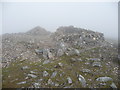
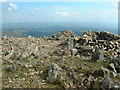
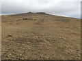
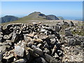
Situated on Mynydd Moel, the eastern summit of the Cader Idris range there is a large rectangular walkers shelter and an associated conical pile of stones. The site spans the space available (some 20m diameter) at the summit, which is bare but for the mass of rocks.
The Gwynedd Archaeology Trust records the following: 'A cairn stands on Mynydd Moel, 10m to the SE of the highest point at 855m on the edge of steep crags. It comprises a low spread of stone, 15m diameter, heavily rebuilt to give a rectangular shelter, but with an arc of kerb on the SW and a stretch of 1m high facing formed by large stones set as headers filling a shallow gully to the NE.'
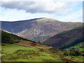
The site has extensive views including the Mawddach Estuary and the mountains of north and mid Wales.
You may be viewing yesterday's version of this page. To see the most up to date information please register for a free account.
")
")
")
")
Do not use the above information on other web sites or publications without permission of the contributor.
Nearby Images from Geograph Britain and Ireland:
©2010(licence)
©2018(licence)
©2009(licence)
©2018(licence)
©2013(licence)
The above images may not be of the site on this page, they are loaded from Geograph.
Please Submit an Image of this site or go out and take one for us!
Click here to see more info for this site
Nearby sites
Key: Red: member's photo, Blue: 3rd party photo, Yellow: other image, Green: no photo - please go there and take one, Grey: site destroyed
Download sites to:
KML (Google Earth)
GPX (GPS waypoints)
CSV (Garmin/Navman)
CSV (Excel)
To unlock full downloads you need to sign up as a Contributory Member. Otherwise downloads are limited to 50 sites.
Turn off the page maps and other distractions
Nearby sites listing. In the following links * = Image available
1.5km WSW 253° Cairns East of Cader Idris* Barrow Cemetery (SH714132)
1.6km WNW 290° Llyn Gafr Standing Stone* Standing Stone (Menhir) (SH713142)
1.7km WNW 292° Llyn Gafr Mounds* Artificial Mound (SH712143)
1.8km WNW 295° Llyn Gafr Hut Circle Settlement* Ancient Village or Settlement (SH712144)
2.7km N 5° Coed Croes Cairn* Cairn (SH731163)
3.4km W 265° Rhiw Gwredydd Cairns* Cairn (SH694134)
4.0km N 356° Ffynnon Fair (Dolgellau)* Holy Well or Sacred Spring (SH72601755)
4.0km WNW 302° Craig y Castell* Hillfort (SH69451578)
4.2km NW 315° Waen Fechan Cairn 4* Cairn (SH699166)
4.2km NW 309° Craig Y Castell Stone Feature* Modern Stone Circle etc (SH696163)
4.2km N 350° Pandy'r Odyn Well* Holy Well or Sacred Spring (SH722178)
4.3km NW 313° Waen Fechan cairn 2* Cairn (SH69731660)
4.3km NW 309° Cairn North of Craig Y Castell.* Round Cairn (SH695164)
4.3km N 356° Dolgellau* Modern Stone Circle etc (SH72581792)
4.4km NW 312° Waen Fechan cairn 1* Cairn (SH69621666)
4.5km W 267° Tyrrau Mawr* Cairn (SH68281352)
4.5km NW 314° Waen Fechan Cairn 3* Cairn (SH696168)
5.5km N 351° Pentre Farm Barrow* Round Barrow(s) (SH721191)
5.8km N 358° Coed Pen Y Bryn Defended Settlement* Hillfort (SH727194)
5.8km WNW 289° Ty'n Llidiart Standing Stone* Standing Stone (Menhir) (SH673156)
5.9km WNW 286° Ty'n Llidiart Cairn* Cairn (SH6720015360)
5.9km W 268° Graig Las Hut Circle* Ancient Village or Settlement (SH6690013570)
6.0km W 268° Graig Las Round Cairn* Round Cairn (SH6683013600)
6.0km W 268° Graig Las Cairn 2* Cairn (SH6682913598)
6.0km W 268° Graig Las Cairn* Cairn (SH6680013500)
View more nearby sites and additional images


 We would like to know more about this location. Please feel free to add a brief description and any relevant information in your own language.
 Wir möchten mehr über diese Stätte erfahren. Bitte zögern Sie nicht, eine kurze Beschreibung und relevante Informationen in Deutsch hinzuzufügen.
 Nous aimerions en savoir encore un peu sur les lieux. S'il vous plaît n'hesitez pas à ajouter une courte description et tous les renseignements pertinents dans votre propre langue.
 Quisieramos informarnos un poco más de las lugares. No dude en añadir una breve descripción y otros datos relevantes en su propio idioma.