


<< Our Photo Pages >> Muirkirk Stane - Standing Stone (Menhir) in Scotland in East Ayrshire
Submitted by kerrywoman on Tuesday, 25 September 2007 Page Views: 12488
Neolithic and Bronze AgeSite Name: Muirkirk Stane Alternative Name: LightshawCountry: Scotland
NOTE: This site is 4.1 km away from the location you searched for.
County: East Ayrshire Type: Standing Stone (Menhir)
Nearest Village: Muirkirk
Map Ref: NS71622821
Latitude: 55.530682N Longitude: 4.035506W
Condition:
| 5 | Perfect |
| 4 | Almost Perfect |
| 3 | Reasonable but with some damage |
| 2 | Ruined but still recognisable as an ancient site |
| 1 | Pretty much destroyed, possibly visible as crop marks |
| 0 | No data. |
| -1 | Completely destroyed |
| 5 | Superb |
| 4 | Good |
| 3 | Ordinary |
| 2 | Not Good |
| 1 | Awful |
| 0 | No data. |
| 5 | Can be driven to, probably with disabled access |
| 4 | Short walk on a footpath |
| 3 | Requiring a bit more of a walk |
| 2 | A long walk |
| 1 | In the middle of nowhere, a nightmare to find |
| 0 | No data. |
| 5 | co-ordinates taken by GPS or official recorded co-ordinates |
| 4 | co-ordinates scaled from a detailed map |
| 3 | co-ordinates scaled from a bad map |
| 2 | co-ordinates of the nearest village |
| 1 | co-ordinates of the nearest town |
| 0 | no data |
Be the first person to rate this site - see the 'Contribute!' box in the right hand menu.
Internal Links:
External Links:
I have visited· I would like to visit
Ogham visited on 22nd Jul 2019 - their rating: Cond: 3 Amb: 3 Access: 4 The site just off the road, access through field gate.
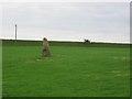
meglett visited on 1st Jan 2000 - their rating: Cond: 3 Amb: 4 Access: 5 This site is local to myself, and I have wanted to point out the other two stones just a little behind and to the right of the stone veiwed from the road. There is a opencast mine close by so its possible there may be other stones now lost.
A few miles east there apears to be a burial mound also right next to the road, but I have no information on that sight apart from the fact that I have looked at it on a few occasions.
Both sights can be seen on google street view. Have to park on verge in order to view!
Average ratings for this site from all visit loggers: Condition: 3 Ambience: 3.5 Access: 4.5
")
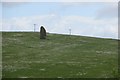
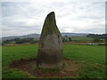
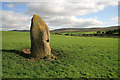
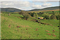
Standing stone just east of the village of Muirkirk. On the A70 the stone is in a field on the left hand side of the road and can be easily seen.
More information can be found on Canmore ID 45529, which add the stone is "situated on a low spur in a pasture field. There are several small indentations in the surface of the N face, which superficially resemble cup-marks, but they are almost certainly natural."
You may be viewing yesterday's version of this page. To see the most up to date information please register for a free account.
")
")
")
")
Do not use the above information on other web sites or publications without permission of the contributor.
Nearby Images from Geograph Britain and Ireland:
©2015(licence)
©2021(licence)
©2008(licence)
©2005(licence)
©2008(licence)
The above images may not be of the site on this page, they are loaded from Geograph.
Please Submit an Image of this site or go out and take one for us!
Click here to see more info for this site
Nearby sites
Key: Red: member's photo, Blue: 3rd party photo, Yellow: other image, Green: no photo - please go there and take one, Grey: site destroyed
Download sites to:
KML (Google Earth)
GPX (GPS waypoints)
CSV (Garmin/Navman)
CSV (Excel)
To unlock full downloads you need to sign up as a Contributory Member. Otherwise downloads are limited to 50 sites.
Turn off the page maps and other distractions
Nearby sites listing. In the following links * = Image available
8.1km NNE 30° Standingstone Hill (Lesmahagow) Standing Stone (Menhir) (NS759351)
12.6km S 184° St. Conal's stone* Rock Art (NS7044715674)
14.6km WNW 300° Loanfoot* Chambered Cairn (NS592360)
16.2km N 354° St Anne's Well (Strathaven) Holy Well or Sacred Spring (NS70394438)
16.6km E 92° Wildshaw Burn* Stone Circle (NS882271)
17.1km N 351° Three Stanes (Strathaven) Standing Stones (NS69574524)
17.8km SSE 159° Crawick Multiverse* Modern Stone Circle etc (NS7763311439)
17.8km WNW 300° The Dagon Stone* Standing Stone (Menhir) (NS56333746)
18.4km NE 37° Clarkston (Dillarburn) Standing Stone (Menhir) (NS832426)
19.3km ESE 103° Blackhill Hillfort (NS9032423216)
19.6km NNE 33° Blackhill (Hazelbank) Standing Stone (Menhir) (NS82904423)
19.8km WNW 290° Gallow Law (Hillend) Cairn (NS5313535382)
20.6km W 261° Ballochmyle* Rock Art (NS5111725565)
21.1km N 349° Shawton (Chapeltown) Standing Stone (Menhir) (NS68124906)
22.0km WNW 292° Molmont Stone Circle (NS514371)
22.1km NE 44° St Patrick's Well (Lanark) Holy Well or Sacred Spring (NS8744443652)
22.3km E 96° Cold Chapel prehistoric settlement* Ancient Village or Settlement (NS93782512)
22.7km ESE 105° Kirkton Fort* Hillfort (NS935218)
23.1km E 99° Arbory Hill* Hillfort (NS944238)
23.5km NNE 31° Braidwood (Carluke) Standing Stone (Menhir) (NS84354799)
23.7km E 88° Devonshaw Hill* Hillfort (NS954283)
23.8km ESE 104° Kirkton Fort and Settlement* Hillfort (NS946216)
24.0km NNE 19° Dalserf Sculptured Stone (NS79985071)
24.3km ESE 104° Castle Crawford Farm Fort* Hillfort (NS951218)
25.3km SW 222° Nith Lodge Stone Circle (NS540100)
View more nearby sites and additional images


 We would like to know more about this location. Please feel free to add a brief description and any relevant information in your own language.
 Wir möchten mehr über diese Stätte erfahren. Bitte zögern Sie nicht, eine kurze Beschreibung und relevante Informationen in Deutsch hinzuzufügen.
 Nous aimerions en savoir encore un peu sur les lieux. S'il vous plaît n'hesitez pas à ajouter une courte description et tous les renseignements pertinents dans votre propre langue.
 Quisieramos informarnos un poco más de las lugares. No dude en añadir una breve descripción y otros datos relevantes en su propio idioma.