 with our Megalithic Portal iPhone app")
, Aubrey Burl")
<< Our Photo Pages >> Cairn West of Bwlch Cowlyd - Cairn in Wales in Gwynedd
Submitted by TAlanJones on Saturday, 17 April 2021 Page Views: 468
Neolithic and Bronze AgeSite Name: Cairn West of Bwlch CowlydCountry: Wales County: Gwynedd Type: Cairn
Nearest Town: Bethesda Nearest Village: Capel Curig
Map Ref: SH712608
Latitude: 53.128756N Longitude: 3.926456W
Condition:
| 5 | Perfect |
| 4 | Almost Perfect |
| 3 | Reasonable but with some damage |
| 2 | Ruined but still recognisable as an ancient site |
| 1 | Pretty much destroyed, possibly visible as crop marks |
| 0 | No data. |
| -1 | Completely destroyed |
| 5 | Superb |
| 4 | Good |
| 3 | Ordinary |
| 2 | Not Good |
| 1 | Awful |
| 0 | No data. |
| 5 | Can be driven to, probably with disabled access |
| 4 | Short walk on a footpath |
| 3 | Requiring a bit more of a walk |
| 2 | A long walk |
| 1 | In the middle of nowhere, a nightmare to find |
| 0 | No data. |
| 5 | co-ordinates taken by GPS or official recorded co-ordinates |
| 4 | co-ordinates scaled from a detailed map |
| 3 | co-ordinates scaled from a bad map |
| 2 | co-ordinates of the nearest village |
| 1 | co-ordinates of the nearest town |
| 0 | no data |
Internal Links:
External Links:
")
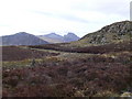
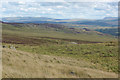
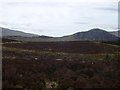
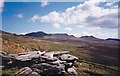
Situated high in the Carneddau foothills the cairn lies 60m south of the water channel or sluice that meanders towards Llyn Cowlyd, and 10m west of a narrow stream.
This is a glorious environment with Cwm Ogwen (valley) and the Glyder and Carneddau mountains to the west drawing walkers throughout the year.
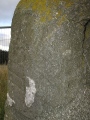
The cairn is oval in shape at 9m north to south and raised to about 0.4m. It has been disturbed in two places at it's centre.
You may be viewing yesterday's version of this page. To see the most up to date information please register for a free account.
")
")
")
Do not use the above information on other web sites or publications without permission of the contributor.
Nearby Images from Geograph Britain and Ireland:
©2010(licence)
©2009(licence)
©2009(licence)
©2010(licence)
©2016(licence)
The above images may not be of the site on this page, they are loaded from Geograph.
Please Submit an Image of this site or go out and take one for us!
Click here to see more info for this site
Nearby sites
Key: Red: member's photo, Blue: 3rd party photo, Yellow: other image, Green: no photo - please go there and take one, Grey: site destroyed
Download sites to:
KML (Google Earth)
GPX (GPS waypoints)
CSV (Garmin/Navman)
CSV (Excel)
To unlock full downloads you need to sign up as a Contributory Member. Otherwise downloads are limited to 50 sites.
Turn off the page maps and other distractions
Nearby sites listing. In the following links * = Image available
399m E 88° Bwlch Cowlyd Cairn* Cairn (SH716608)
411m ENE 74° Bwlch Cowlyd Hut Circles* Ancient Village or Settlement (SH716609)
517m ENE 70° Maen Trichwmwd Natural Stone / Erratic / Other Natural Feature (SH7169260962)
688m W 268° Tal y Braich Cairn and Standing Stone Cairn (SH70516079)
698m W 268° Tal y Braich* Stone Circle (SH705608)
1.6km NNE 13° Pen Llithrig Y Wrach* Cairn (SH71606232)
2.0km W 266° Hut Circle Settlement SE of Glan Llugwy Ancient Village or Settlement (SH69226071)
2.4km S 171° Creigiau'r Gelli Cairn Cairn (SH715584)
2.7km SSW 209° Nant y Gors Cairn and Cist* Cairn (SH6980458433)
2.8km SSW 208° Nant y Gors Hut Circle Settlement* Ancient Village or Settlement (SH6982058413)
2.9km SSE 154° Clogwyn Mawr Hut Circle* Ancient Village or Settlement (SH7240058200)
3.1km WSW 248° Gwern Gof Isaf* Ancient Village or Settlement (SH68265971)
3.6km SE 145° Carnedd Coed Bryn Brethynau* Round Cairn (SH7319057750)
4.6km NW 320° Carnedd Llewelyn* Cairn (SH683644)
5.0km WSW 251° Sion a Siân (Adam and Eve) Stones* Natural Stone / Erratic / Other Natural Feature (SH664593)
5.1km SSW 210° Dyffryn Mymbyr Round Barrow(s) (SH68565648)
5.1km SSW 210° Dyffryn Mymbyr* Standing Stone (Menhir) (SH68565648)
5.3km SSE 149° Bryn y Gefeiliau Ancient Trackway* Ancient Trackway (SH7379856215)
5.5km W 261° Nant Bochllwyd Hut Circle Settlement* Ancient Village or Settlement (SH6577060100)
5.5km WNW 291° Cairn SW of Carnedd Dafydd* Cairn (SH66136293)
5.5km WNW 291° Carnedd Dafydd (Conwy)* Cairn (SH661629)
5.5km SSE 148° Cefn Glas Round Cairn* Round Cairn (SH7401056010)
5.6km NNW 334° Foel Grach* Cairn (SH68886589)
5.7km WNW 287° Carnedd Fach* Cairn (SH6580062620)
5.7km N 353° Pant y Griafolen* Ancient Village or Settlement (SH707665)
View more nearby sites and additional images


 We would like to know more about this location. Please feel free to add a brief description and any relevant information in your own language.
 Wir möchten mehr über diese Stätte erfahren. Bitte zögern Sie nicht, eine kurze Beschreibung und relevante Informationen in Deutsch hinzuzufügen.
 Nous aimerions en savoir encore un peu sur les lieux. S'il vous plaît n'hesitez pas à ajouter une courte description et tous les renseignements pertinents dans votre propre langue.
 Quisieramos informarnos un poco más de las lugares. No dude en añadir una breve descripción y otros datos relevantes en su propio idioma.