


<< Our Photo Pages >> Llanerch Fedw - Cairn in Wales in Conwy
Submitted by TimPrevett on Tuesday, 24 August 2004 Page Views: 7755
Neolithic and Bronze AgeSite Name: Llanerch FedwCountry: Wales
NOTE: This site is 0.5 km away from the location you searched for.
County: Conwy Type: Cairn
Nearest Town: Penmaenmawr Nearest Village: Llanfairfechan
Map Ref: SH709720
Latitude: 53.229302N Longitude: 3.935463W
Condition:
| 5 | Perfect |
| 4 | Almost Perfect |
| 3 | Reasonable but with some damage |
| 2 | Ruined but still recognisable as an ancient site |
| 1 | Pretty much destroyed, possibly visible as crop marks |
| 0 | No data. |
| -1 | Completely destroyed |
| 5 | Superb |
| 4 | Good |
| 3 | Ordinary |
| 2 | Not Good |
| 1 | Awful |
| 0 | No data. |
| 5 | Can be driven to, probably with disabled access |
| 4 | Short walk on a footpath |
| 3 | Requiring a bit more of a walk |
| 2 | A long walk |
| 1 | In the middle of nowhere, a nightmare to find |
| 0 | No data. |
| 5 | co-ordinates taken by GPS or official recorded co-ordinates |
| 4 | co-ordinates scaled from a detailed map |
| 3 | co-ordinates scaled from a bad map |
| 2 | co-ordinates of the nearest village |
| 1 | co-ordinates of the nearest town |
| 0 | no data |
Internal Links:
External Links:
I have visited· I would like to visit
TimPrevett has visited here
")
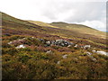
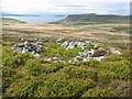
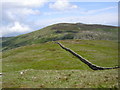
A pair of cairns upon the southern side of the Roman road.
The most eastern (SH709720) is quite impressive, with a very defined ring and considerable height to the monument, especially when viewed to the north west. This is worth a visit.
The most western (SH705721) is hard to discern indeed, and is reminiscent of Eyam Moor II and III in terms of its near subterranean character and smothering of bilberries. It has a deep robbed out centre, and some cairn stones can be made out on its western side.
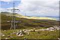
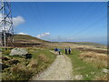
For both of these, careful footing, and accurate map reading using the pylon bases as points of reference is imperative for a visit.
You may be viewing yesterday's version of this page. To see the most up to date information please register for a free account.
")
")
")
Do not use the above information on other web sites or publications without permission of the contributor.
Nearby Images from Geograph Britain and Ireland:
©2013(licence)
©2007(licence)
©2011(licence)
©2022(licence)
©2008(licence)
The above images may not be of the site on this page, they are loaded from Geograph.
Please Submit an Image of this site or go out and take one for us!
Click here to see more info for this site
Nearby sites
Key: Red: member's photo, Blue: 3rd party photo, Yellow: other image, Green: no photo - please go there and take one, Grey: site destroyed
Download sites to:
KML (Google Earth)
GPX (GPS waypoints)
CSV (Garmin/Navman)
CSV (Excel)
To unlock full downloads you need to sign up as a Contributory Member. Otherwise downloads are limited to 50 sites.
Turn off the page maps and other distractions
Nearby sites listing. In the following links * = Image available
580m ESE 106° Bwlch y Ddeufaen N Standing Stone (Menhir) (SH7145671828)
649m ESE 109° Bwlch y Ddeufaen S Standing Stone (Menhir) (SH7151071772)
804m ESE 118° Bwlch y Ddeufaen* Standing Stones (SH716716)
804m ESE 118° Barclodiad-y-Gawres (Conwy)* Cairn (SH716716)
1.4km S 187° Carnedd y Ddelw* Clava Cairn (SH707706)
1.5km W 280° Maen Ffordd Rufeinig* Standing Stone (Menhir) (SH694723)
1.7km ESE 112° Cerrig Pryfaid* Stone Circle (SH72467133)
1.7km WNW 281° Ffridd Newydd Arrow stones* Rock Art (SH69237238)
1.8km W 275° Carn yr Llechwedd* Cairn (SH691722)
1.9km NW 305° Garreg Fawr* Carving (SH6939373132)
1.9km WSW 237° Afon Anafon Arrow Stone* Sculptured Stone (SH69267098)
2.0km NNW 332° Dinas Settlement* Ancient Village or Settlement (SH700738)
2.1km NE 38° Gwynion Cairns* Barrow Cemetery (SH72257366)
2.3km W 274° Foel Ganol* Cairn (SH68597221)
2.4km E 97° Cae Coch* Standing Stone (Menhir) (SH73287166)
2.4km S 180° Carnedd Penyborth Goch Cairn Cairn (SH70846959)
2.5km NNE 17° Moelfre cairn* Cairn (SH71727441)
2.6km E 95° Rowen Hut Circles* Ancient Village or Settlement (SH735717)
2.7km W 267° Foel Dduarth (East)* Ancient Village or Settlement (SH68217191)
2.7km E 95° Rowen Cross Incised Stone* Early Christian Sculptured Stone (SH736717)
2.8km NE 36° Cerrig Gwynion (Conwy)* Cist (SH72627423)
2.8km NNE 15° Graig Lwyd Cairns* Cairn (SH717747)
2.8km NNE 18° Cors Y Carneddau* Stone Circle (SH71847467)
2.9km NNE 25° Cefn Coch (Penmaenmawr)* Ring Cairn (SH72167457)
2.9km W 269° Nant y Felin-fach Cairn* Cairn (SH68027203)
View more nearby sites and additional images


 We would like to know more about this location. Please feel free to add a brief description and any relevant information in your own language.
 Wir möchten mehr über diese Stätte erfahren. Bitte zögern Sie nicht, eine kurze Beschreibung und relevante Informationen in Deutsch hinzuzufügen.
 Nous aimerions en savoir encore un peu sur les lieux. S'il vous plaît n'hesitez pas à ajouter une courte description et tous les renseignements pertinents dans votre propre langue.
 Quisieramos informarnos un poco más de las lugares. No dude en añadir una breve descripción y otros datos relevantes en su propio idioma.