 with our Megalithic Portal iPhone app")


<< Text Pages >> Carn Wen (Tre-Taliesin) - Cairn in Wales in Ceredigion
Submitted by SiFry on Saturday, 15 May 2021 Page Views: 629
Date UncertainSite Name: Carn Wen (Tre-Taliesin)Country: Wales
NOTE: This site is 0.6 km away from the location you searched for.
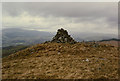
County: Ceredigion Type: Cairn
Nearest Village: Tre-Taliesin
Map Ref: SN689927
Latitude: 52.516368N Longitude: 3.933448W
Condition:
| 5 | Perfect |
| 4 | Almost Perfect |
| 3 | Reasonable but with some damage |
| 2 | Ruined but still recognisable as an ancient site |
| 1 | Pretty much destroyed, possibly visible as crop marks |
| 0 | No data. |
| -1 | Completely destroyed |
| 5 | Superb |
| 4 | Good |
| 3 | Ordinary |
| 2 | Not Good |
| 1 | Awful |
| 0 | No data. |
| 5 | Can be driven to, probably with disabled access |
| 4 | Short walk on a footpath |
| 3 | Requiring a bit more of a walk |
| 2 | A long walk |
| 1 | In the middle of nowhere, a nightmare to find |
| 0 | No data. |
| 5 | co-ordinates taken by GPS or official recorded co-ordinates |
| 4 | co-ordinates scaled from a detailed map |
| 3 | co-ordinates scaled from a bad map |
| 2 | co-ordinates of the nearest village |
| 1 | co-ordinates of the nearest town |
| 0 | no data |
Internal Links:
External Links:
Standing Stone above Tre-Taliesin
Whilst walking in the hills above a cottage we rented in Tre-Taliesin I came across a standing stone in the middle of a cairn. I can’t find any details for it on the web so I’m trying to find out if it is an ancient site. I can’t seem to add an image as I’m working from an iPad.
You may be viewing yesterday's version of this page. To see the most up to date information please register for a free account.
Do not use the above information on other web sites or publications without permission of the contributor.
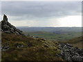
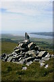
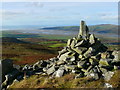
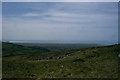
Nearby Images from Geograph Britain and Ireland:
©2009(licence)
©2005(licence)
©2014(licence)
©2005(licence)
©2008(licence)
The above images may not be of the site on this page, they are loaded from Geograph.
Please Submit an Image of this site or go out and take one for us!
Click here to see more info for this site
Nearby sites
Key: Red: member's photo, Blue: 3rd party photo, Yellow: other image, Green: no photo - please go there and take one, Grey: site destroyed
Download sites to:
KML (Google Earth)
GPX (GPS waypoints)
CSV (Garmin/Navman)
CSV (Excel)
To unlock full downloads you need to sign up as a Contributory Member. Otherwise downloads are limited to 50 sites.
Turn off the page maps and other distractions
Nearby sites listing. In the following links * = Image available
1.9km SE 141° Moel y Llyn Stone Circle* Stone Circle (SN7010091160)
2.3km SW 228° Bedd Taliesin* Round Cairn (SN67149121)
4.8km NNE 32° Brwyno-Canol* Stone Row / Alignment (SN71569666)
5.1km S 178° Cwmere Farm Standing Stone* Standing Stone (Menhir) (SN689876)
6.2km SE 135° Carn Owen* Cairn (SN732882)
6.6km NW 325° Carn March Arthur Stone* Standing Stone (Menhir) (SN6526298167)
7.0km NNW 327° Llyn Barfog Stone Standing Stone (Menhir) (SN6521298686)
7.0km NNW 326° Llyn Barfog Cairn* Cairn (SN65159868)
7.4km SSW 195° Banc Troed Rhiw Seiri* Ring Cairn (SN6679385583)
7.8km S 177° Pen-Y-Castell* Standing Stone (Menhir) (SN69138487)
7.9km S 178° Pen-Y-Castell Hillfort Hillfort (SN68958480)
7.9km NNW 339° Eglwys Gwyddelod* Stone Circle (SH66260016)
8.3km S 179° Garn Wen (NE) Cairn (SN68788436)
8.4km SE 131° Aber Camddwr Cairn* Cairn (SN75058700)
8.4km NW 312° Happy Valley Tumulus* Round Barrow(s) (SN62809846)
8.5km W 267° Borth Sands Submerged Forest* Natural Stone / Erratic / Other Natural Feature (SN60429255)
8.5km S 181° Garn Wen Barrow Cairn (SN68518421)
8.5km ESE 123° Drosgol Carneddau Cairn (I)* Cairn (SN7593387856)
8.5km ESE 123° Drosgol Carneddau Cairn (II)* Cairn (SN75968785)
8.6km S 171° Pen-Y-Bryn-Mawr Cairn (SN70018412)
8.8km SW 227° St Michael's Church Well Holy Well or Sacred Spring (SN62328687)
8.9km SSW 209° Cwrt Enclosure Ancient Village or Settlement (SN64348503)
9.0km S 181° Stones of the Lamb* Standing Stone (Menhir) (SN68568367)
9.1km ESE 115° Craig y Dullfan ring cairn* Cairn (SN771887)
9.3km SSE 147° Disgwylfa Fawr Round Barrow* Round Barrow(s) (SN73738474)
View more nearby sites and additional images

")
 We would like to know more about this location. Please feel free to add a brief description and any relevant information in your own language.
 Wir möchten mehr über diese Stätte erfahren. Bitte zögern Sie nicht, eine kurze Beschreibung und relevante Informationen in Deutsch hinzuzufügen.
 Nous aimerions en savoir encore un peu sur les lieux. S'il vous plaît n'hesitez pas à ajouter une courte description et tous les renseignements pertinents dans votre propre langue.
 Quisieramos informarnos un poco más de las lugares. No dude en añadir una breve descripción y otros datos relevantes en su propio idioma.