 with our Megalithic Portal iPhone app")

<< Our Photo Pages >> Dyffryn Mymbyr - Standing Stone (Menhir) in Wales in Conwy (Bwrdeistref Sirol)
Submitted by vicky on Wednesday, 01 October 2003 Page Views: 7175
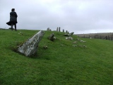
Neolithic and Bronze AgeSite Name: Dyffryn MymbyrCountry: Wales
NOTE: This site is 0.3 km away from the location you searched for.
County: Conwy (Bwrdeistref Sirol) Type: Standing Stone (Menhir)
Nearest Town: Betws-y-Coed Nearest Village: Capel Curig
Map Ref: SH68565648 Landranger Map Number: 115
Latitude: 53.089302N Longitude: 3.964118W
Condition:
| 5 | Perfect |
| 4 | Almost Perfect |
| 3 | Reasonable but with some damage |
| 2 | Ruined but still recognisable as an ancient site |
| 1 | Pretty much destroyed, possibly visible as crop marks |
| 0 | No data. |
| -1 | Completely destroyed |
| 5 | Superb |
| 4 | Good |
| 3 | Ordinary |
| 2 | Not Good |
| 1 | Awful |
| 0 | No data. |
| 5 | Can be driven to, probably with disabled access |
| 4 | Short walk on a footpath |
| 3 | Requiring a bit more of a walk |
| 2 | A long walk |
| 1 | In the middle of nowhere, a nightmare to find |
| 0 | No data. |
| 5 | co-ordinates taken by GPS or official recorded co-ordinates |
| 4 | co-ordinates scaled from a detailed map |
| 3 | co-ordinates scaled from a bad map |
| 2 | co-ordinates of the nearest village |
| 1 | co-ordinates of the nearest town |
| 0 | no data |
Internal Links:
External Links:
I have visited· I would like to visit
elad13 would like to visit
")
Have you visited this site? Please add a comment below.
You may be viewing yesterday's version of this page. To see the most up to date information please register for a free account.
 (PID:137784)")
 (PID:143642)")
 (PID:137791)")
")
")
")
")
")
")
")
")
 (PID:143646)")
 (PID:143645)")
 (PID:143644)")
 (PID:143643)")
 (PID:143641)")
 (PID:143640)")
 (PID:143639)")
 (PID:143638)")
 (PID:143637)")
 (PID:143636)")
 (PID:137792)")
 (PID:137790)")
 (PID:137789)")
 (PID:137788)")
These are just the first 25 photos of Dyffryn Mymbyr. If you log in with a free user account you will be able to see our entire collection.
Do not use the above information on other web sites or publications without permission of the contributor.
Click here to see more info for this site
Nearby sites
Key: Red: member's photo, Blue: 3rd party photo, Yellow: other image, Green: no photo - please go there and take one, Grey: site destroyed
Download sites to:
KML (Google Earth)
GPX (GPS waypoints)
CSV (Garmin/Navman)
CSV (Excel)
To unlock full downloads you need to sign up as a Contributory Member. Otherwise downloads are limited to 50 sites.
Turn off the page maps and other distractions
Nearby sites listing. In the following links * = Image available
nankm 0° Dyffryn Mymbyr Round Barrow(s) (SH68565648)
2.3km NNE 31° Nant y Gors Hut Circle Settlement* Ancient Village or Settlement (SH6982058413)
2.3km NNE 31° Nant y Gors Cairn and Cist* Cairn (SH6980458433)
2.7km SE 131° Carnedd Moel Siabod* Cairn (SH70535469)
2.7km SW 221° Nant-y-Llys* Cairn (SH66725450)
3.2km N 353° Gwern Gof Isaf* Ancient Village or Settlement (SH68265971)
3.5km W 268° Dyffryn Mymbyr (stone circle)* Stone Circle (SH6505656464)
3.5km NE 55° Creigiau'r Gelli Cairn Cairn (SH715584)
3.5km NW 321° Sion a Siân (Adam and Eve) Stones* Natural Stone / Erratic / Other Natural Feature (SH664593)
3.9km SW 231° Cwm Dyli North settlement* Ancient Village or Settlement (SH65485415)
4.2km ENE 64° Clogwyn Mawr Hut Circle* Ancient Village or Settlement (SH7240058200)
4.3km N 7° Hut Circle Settlement SE of Glan Llugwy Ancient Village or Settlement (SH69226071)
4.6km NW 321° Nant Bochllwyd Hut Circle Settlement* Ancient Village or Settlement (SH6577060100)
4.7km SSE 166° Ty'n y Ddol Hut Circle Settlement* Ancient Village or Settlement (SH6955051900)
4.7km NNE 23° Tal y Braich Cairn and Standing Stone Cairn (SH70516079)
4.7km NNE 23° Tal y Braich* Stone Circle (SH705608)
4.8km ENE 73° Carnedd Coed Bryn Brethynau* Round Cairn (SH7319057750)
4.8km ESE 106° Cefn Glas Hut Circle Settlement* Ancient Village or Settlement (SH7318055010)
5.1km NNE 30° Cairn West of Bwlch Cowlyd* Cairn (SH712608)
5.1km ESE 104° Cefn Glas Barrow Cemetery* Barrow Cemetery (SH735551)
5.1km E 100° Hut Circle Settlement N of Cefn Glas* Ancient Village or Settlement (SH7362055450)
5.2km E 91° Bryn y Gefeiliau Ancient Trackway* Ancient Trackway (SH7379856215)
5.3km NNE 33° Bwlch Cowlyd Cairn* Cairn (SH716608)
5.4km NNE 33° Bwlch Cowlyd Hut Circles* Ancient Village or Settlement (SH716609)
5.5km E 93° Cefn Glas Round Cairn* Round Cairn (SH7401056010)
View more nearby sites and additional images


 We would like to know more about this location. Please feel free to add a brief description and any relevant information in your own language.
 Wir möchten mehr über diese Stätte erfahren. Bitte zögern Sie nicht, eine kurze Beschreibung und relevante Informationen in Deutsch hinzuzufügen.
 Nous aimerions en savoir encore un peu sur les lieux. S'il vous plaît n'hesitez pas à ajouter une courte description et tous les renseignements pertinents dans votre propre langue.
 Quisieramos informarnos un poco más de las lugares. No dude en añadir una breve descripción y otros datos relevantes en su propio idioma.