


<< Our Photo Pages >> Water hill cairn - Cairn in England in Devon
Submitted by Bladup on Monday, 02 September 2013 Page Views: 2387
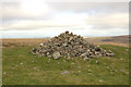
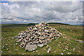
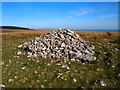
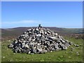
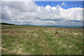
Neolithic and Bronze AgeSite Name: Water hill cairn Alternative Name: King's Oven Cairn; Water Hill Chambered Cairn; Grinsell Chagford 6Country: England County: Devon Type: Cairn
Nearest Town: Princetown Nearest Village: Lettaford / Postbridge
Map Ref: SX67158128
Latitude: 50.616057N Longitude: 3.879186W
Condition:
| 5 | Perfect |
| 4 | Almost Perfect |
| 3 | Reasonable but with some damage |
| 2 | Ruined but still recognisable as an ancient site |
| 1 | Pretty much destroyed, possibly visible as crop marks |
| 0 | No data. |
| -1 | Completely destroyed |
| 5 | Superb |
| 4 | Good |
| 3 | Ordinary |
| 2 | Not Good |
| 1 | Awful |
| 0 | No data. |
| 5 | Can be driven to, probably with disabled access |
| 4 | Short walk on a footpath |
| 3 | Requiring a bit more of a walk |
| 2 | A long walk |
| 1 | In the middle of nowhere, a nightmare to find |
| 0 | No data. |
| 5 | co-ordinates taken by GPS or official recorded co-ordinates |
| 4 | co-ordinates scaled from a detailed map |
| 3 | co-ordinates scaled from a bad map |
| 2 | co-ordinates of the nearest village |
| 1 | co-ordinates of the nearest town |
| 0 | no data |
Internal Links:
External Links:
I have visited· I would like to visit
graemefield visited on 18th May 2017 - their rating: Cond: 3 Amb: 5 Access: 3
Mikehj visited - their rating: Cond: 3 Amb: 3 Access: 3
Average ratings for this site from all visit loggers: Condition: 3 Ambience: 4 Access: 3
")
Update November 2019: This cairn is featured on the Prehistoric Dartmoor Walks (PDW) website - see their entry for the King's Oven (Water Hill) Cairn, which tells us: "(This cairn is) on the rounded summit of Water Hill is the remains of a substantial round cairn 18.0 metres in diameter and up to 1.4 metres high in the east and 0.9 metres in the west. The whole of the central area of the cairn has been robbed to construct a superimposed modern boundary cairn 4.0 metres in diam and 2.1 metres high".
The cairn is also recorded as Pastscape Monument No. 443801, as MDV6675 (Barrow, King Arthur's Oven) on the Devon and Dartmoor HER, and scheduled as part of Historic England List Entry No. 1019225 (Two cairns on the summit of Water Hill 450m north west of Warren House Inn).
You may be viewing yesterday's version of this page. To see the most up to date information please register for a free account.
")
Do not use the above information on other web sites or publications without permission of the contributor.
Nearby Images from Geograph Britain and Ireland:
©2009(licence)
©2010(licence)
©2019(licence)
©2005(licence)
©2009(licence)
The above images may not be of the site on this page, they are loaded from Geograph.
Please Submit an Image of this site or go out and take one for us!
Click here to see more info for this site
Nearby sites
Key: Red: member's photo, Blue: 3rd party photo, Yellow: other image, Green: no photo - please go there and take one, Grey: site destroyed
Download sites to:
KML (Google Earth)
GPX (GPS waypoints)
CSV (Garmin/Navman)
CSV (Excel)
To unlock full downloads you need to sign up as a Contributory Member. Otherwise downloads are limited to 50 sites.
Turn off the page maps and other distractions
Nearby sites listing. In the following links * = Image available
913m ENE 67° Bennet's Cross* Ancient Cross (SX68008162)
1.2km N 5° Hurston Ridge* Multiple Stone Rows / Avenue (SX67308251)
1.3km N 7° Hurston Ridge Settlement* Ancient Village or Settlement (SX67338253)
1.4km SSE 157° Soussons Down Stone Row Multiple Stone Rows / Avenue (SX6767079980)
1.6km ENE 75° Birch Tor Cairn* Cairn (SX6868681654)
1.6km NNE 14° Chagford Common Cairn* Cairn (SX6757182800)
1.6km NE 55° Bush Down Settlement* Ancient Village or Settlement (SX6849282173)
1.7km SSE 160° Soussons Down Cairns* Barrow Cemetery (SX6770079671)
1.7km W 261° Stannon Newtake cist* Cist (SX65468105)
1.7km NW 319° Assycombe* Multiple Stone Rows / Avenue (SX66058260)
1.7km NW 321° Assycombe Hill* Cairn (SX66108264)
1.8km W 278° White Ridge stone row* Stone Row / Alignment (SX65408156)
1.8km W 263° Stannon Newtake West Cairn and row* Multiple Stone Rows / Avenue (SX65338110)
1.9km ESE 103° Challacombe Down Cairn Circle* Cairn (SX68968083)
1.9km ESE 103° Challacombe rows* Multiple Stone Rows / Avenue (SX68988082)
1.9km ESE 105° Challacombe Down Standing Stone* Standing Stone (Menhir) (SX69028072)
2.3km NNW 337° Lowton Brook West Settlement* Ancient Village or Settlement (SX663834)
2.3km WNW 292° White Ridge cairn* Round Cairn (SX65028218)
2.4km ENE 70° Shapley Common Ancient Village or Settlement (SX69428206)
2.5km NNW 344° East Lowton settlement* Ancient Village or Settlement (SX6653783668)
2.5km N 358° The Heath Stone* Standing Stone (Menhir) (SX6712083750)
2.6km S 171° Soussons Common* Stone Circle (SX6751178692)
2.7km E 88° Hookney Tor Cairn* Cairn (SX6990281310)
2.7km N 352° Metherall Settlement* Ancient Village or Settlement (SX66838401)
2.9km SW 222° Maggie Cross* Ancient Cross (SX6516679216)
View more nearby sites and additional images


 We would like to know more about this location. Please feel free to add a brief description and any relevant information in your own language.
 Wir möchten mehr über diese Stätte erfahren. Bitte zögern Sie nicht, eine kurze Beschreibung und relevante Informationen in Deutsch hinzuzufügen.
 Nous aimerions en savoir encore un peu sur les lieux. S'il vous plaît n'hesitez pas à ajouter une courte description et tous les renseignements pertinents dans votre propre langue.
 Quisieramos informarnos un poco más de las lugares. No dude en añadir una breve descripción y otros datos relevantes en su propio idioma.