Featured: Lost Secrets - an adventure during Neolithic times

Lost Secrets - an adventure during Neolithic times

Random Image


Fontanaccia Dolmen

Explore Cornwall with the amazing Megalithic Portal smartphone app

Explore Cornwall with the amazing Megalithic Portal smartphone app

Who's Online

There are currently, 177 guests and 0 members online.

You are a guest. To join in, please register for free by clicking here

Sponsors

<< Our Photo Pages >> Cuckoo Ball Chambered Tomb - Chambered Tomb in England in Devon

Submitted by rogerkread on Thursday, 05 July 2012  Page Views: 4940

Neolithic and Bronze AgeSite Name: Cuckoo Ball Chambered Tomb Alternative Name: Grinsell List A Ugborough 1
Country: England County: Devon Type: Chambered Tomb
Nearest Town: Ivybridge  Nearest Village: Bittaford
Map Ref: SX6596058188
Latitude: 50.408232N  Longitude: 3.887698W
Condition:
5Perfect
4Almost Perfect
3Reasonable but with some damage
2Ruined but still recognisable as an ancient site
1Pretty much destroyed, possibly visible as crop marks
0No data.
-1Completely destroyed
3 Ambience:
5Superb
4Good
3Ordinary
2Not Good
1Awful
0No data.
4 Access:
5Can be driven to, probably with disabled access
4Short walk on a footpath
3Requiring a bit more of a walk
2A long walk
1In the middle of nowhere, a nightmare to find
0No data.
3 Accuracy:
5co-ordinates taken by GPS or official recorded co-ordinates
4co-ordinates scaled from a detailed map
3co-ordinates scaled from a bad map
2co-ordinates of the nearest village
1co-ordinates of the nearest town
0no data
5

Internal Links:
External Links:

I have visited· I would like to visit

Catrinm visited on 14th Apr 2024 - their rating: Cond: 2 Amb: 4 Access: 3 Unusual monument for Dartmoor. Atmospheric spot for a burial chamber.
Cuckoo Ball Chambered Tomb
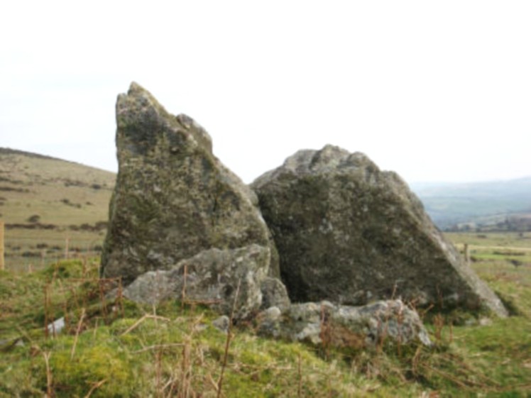
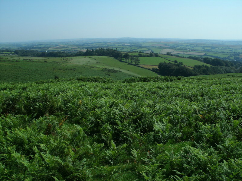
Cuckoo Ball Chambered Tomb submitted by rogerkread : Typical view. (Vote or comment on this photo)
Chambered Tomb in Devon

Description from Pastscape: 'The remains of a long cairn and burial chamber are situated at SX65965819, on a hill-slope at Cuckoo Ball. The cairn, which was probably robbed for newtake walls to the west and north, is 23 metres long by 12 metres wide, aligned north/south, and is 0.7 metre high at the north. The burial chamber is at the north end.'

The tomb is now (July 2012) in its own fenced off enclosure separated from the rest of the intake, just over the boundary wall from the moor. It has been 'tidied up' (encroaching vegetation removed etc) and looks much more impressive than most of the photographs readily available on the internet would suggest. It is very easy to find, eg by following the track which runs around the moor edge below Western Beacon. As you ascend beside the boundary wall the tomb comes clearly into view to your right.

Update September 2019: This chambered tomb is featured on the Prehistoric Dartmoor Walks (PDW) website - see their entry for the Cuckoo Ball Chambered Tomb, which includes a photograph, a description and links to further sources of information.

The tomb is also recorded as Pastscape Monument No. 441197 and as Devon and Dartmoor HER MDV2885 (Cuckoo Ball Chambered Cairn).

This long cairn is also scheduled as Historic England List ID 1012284 (Chambered cairn in Cuckoo Ball newtake).
You may be viewing yesterday's version of this page. To see the most up to date information please register for a free account.
Polished Axe found near Cuckoo Ball Chambered Tomb
Polished Axe found near Cuckoo Ball Chambered Tomb submitted by Andy B : Mark Walker writes: I found this on the southern slopes of Dartmoor in the Lud Brook above Bittaford a few years ago. 300mm x 90 x 30 - Polished hand axe Neolithic ? The nearest coarse grained basic rock igneous from which I think it is made of comes from 80 miles down into Cornwall. There are two neolithic chambered tombs up slope from where this was found. (6 comments - Vote or comment on this photo)

Cuckoo Ball Chambered Tomb
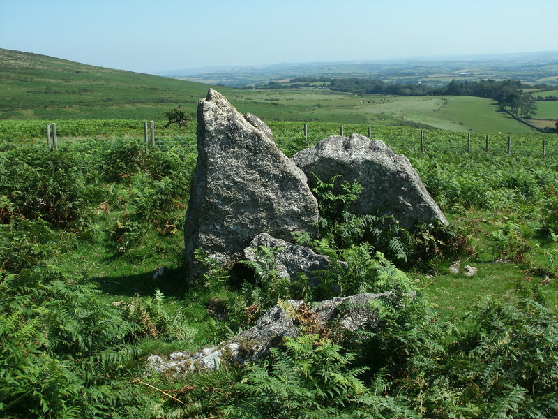
Cuckoo Ball Chambered Tomb submitted by Bladup : Cuckoo Ball Chambered Tomb. (Vote or comment on this photo)

Cuckoo Ball Chambered Tomb
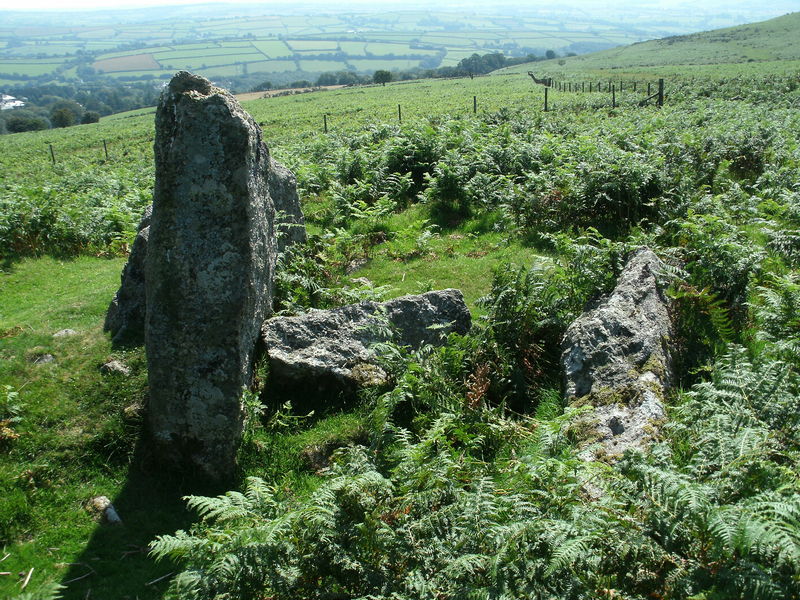
Cuckoo Ball Chambered Tomb submitted by Bladup (Vote or comment on this photo)

Cuckoo Ball Chambered Tomb
Cuckoo Ball Chambered Tomb submitted by Bladup : Looking over the enclosure though it's entrance, It's next to the chambered cairn at SX66055825. (Vote or comment on this photo)

Cuckoo Ball Chambered Tomb
Cuckoo Ball Chambered Tomb submitted by Bladup : The enclosure next to the chambered cairn at SX66055825, You can just make out the bank in this photo curving round from the bottom right though to just above the middle right, Even though the bracken is trying it's hardest not to let us.

Cuckoo Ball Chambered Tomb
Cuckoo Ball Chambered Tomb submitted by Bladup : The enclosure next to the chambered cairn at SX66055825, You can just make out the bank in this photo going from the bottom right though to just above middle left, Even though the bracken is trying it's hardest not to let us see.

Cuckoo Ball Chambered Tomb
Cuckoo Ball Chambered Tomb submitted by Bladup : Cuckoo Ball Chambered Tomb, In the background is Ugborough Beacon.

Cuckoo Ball Chambered Tomb
Cuckoo Ball Chambered Tomb submitted by Bladup : Cuckoo Ball Chambered Tomb with Western Beacon behind.

Do not use the above information on other web sites or publications without permission of the contributor.
Click here to see more info for this site

Nearby sites

Click here to view sites on an interactive OS map

Key: Red: member's photo, Blue: 3rd party photo, Yellow: other image, Green: no photo - please go there and take one, Grey: site destroyed

Download sites to:
KML (Google Earth)
GPX (GPS waypoints)
CSV (Garmin/Navman)
CSV (Excel)

To unlock full downloads you need to sign up as a Contributory Member. Otherwise downloads are limited to 50 sites.


Turn off the page maps and other distractions

Nearby sites listing. In the following links * = Image available
 406m N 6° Butterdon Hill Long Cairn* Long Barrow (SX6601258591)
 680m NNW 327° Butterdon Hill Cairns* Cairn (SX6560158766)
 708m NNW 331° Butterdon Stone Circle* Stone Circle (SX6562958814)
 836m NW 317° Weatherdon Hill Cairns* Barrow Cemetery (SX65405881)
 858m W 269° Addicombe Cairn and Enclosure* Cairn (SX651582)
 983m NE 52° Ugborough Beacon Cairns* Cairn (SX6675558770)
 1.0km N 355° Butterdon East* Stone Row / Alignment (SX65905920)
 1.1km NW 310° Weatherdon Hill (Devon) Ring Cairn (SX65165889)
 1.1km SSW 193° Cantrell* Multiple Stone Rows / Avenue (SX6568957160)
 1.2km N 350° Butterdon Hill Cist* Cist (SX6578159341)
 1.2km NE 39° Ugborough Beacon Propped Stone* Natural Stone / Erratic / Other Natural Feature (SX6674859106)
 1.3km NNW 345° Butterdon Hill Barrow* Round Barrow(s) (SX6566059403)
 1.6km N 353° Spurrells Cross Cairn Circle* Stone Circle (SX658598)
 1.6km NW 309° Butter Brook* Standing Stone (Menhir) (SX64725926)
 1.7km N 355° Spurrell's Cross Row Terminal Cairn Cairn (SX6585859864)
 1.7km N 354° Spurrells Cross Row* Multiple Stone Rows / Avenue (SX6583759896)
 1.8km N 357° Spurrell's Cross* Ancient Cross (SX65915997)
 1.8km NNW 331° Harford S.* Multiple Stone Rows / Avenue (SX651598)
 1.9km NNW 335° Butterbrook* Stone Row / Alignment (SX652599)
 1.9km NW 305° Harford settlement* Ancient Village or Settlement (SX6444559313)
 1.9km NNW 332° Harford Moor N* Stone Row / Alignment (SX651599)
 1.9km NNE 20° Scad Brook* Ancient Village or Settlement (SX6667759981)
 2.1km NNW 347° Butterdon Hill Row* Stone Row / Alignment (SX6553960225)
 2.1km NW 314° Harford Moor Encircled Cairn* Stone Circle (SX6449459677)
 2.2km N 353° Glasscombe Ball North (South Cairn)* Cairn (SX65736041)
View more nearby sites and additional images

<< West Highland Museum

Notre Dame-de-Lorette Alignements >>

Please add your thoughts on this site

Prehistoric Settlements

Prehistoric Settlements

Sponsors

Auto-Translation (Google)

Translate from English into:

"Cuckoo Ball Chambered Tomb" | Login/Create an Account | 1 comment
  
Go back to top of page    Comments are owned by the poster. We aren't responsible for their content.
The Three Peaks Walk – Dartmoor – South Devon. by Andy B on Friday, 12 June 2015
(User Info | Send a Message)
A description of a 4 ½ mile medium circular walk on southern Dartmoor from Blackadon Barn Holiday Cottages. One of my favourite walks anywhere in the world - as this short walk offers so much of what I love about Dartmoor. This area of Dartmoor is often overlooked, with people heading towards the crowds in Princetown, Hay Tor and Postbridge.
Heading north from Blackadon along the resurfaced pathway towards the excellent new double gate and west down to ford the Lud brook, a tributary of the River Erme. Only about 3 meters wide, the stepping stones are great fun.

Through the small gate and up towards a 5 bar gate through which is the open Moor. You have only been walking for 15 minutes and already so much to see – Galloway Belties, Dartmoor Ponies, black sheep and the Buzzards circling overhead. As you close the gate the path is directly in front of you on the eastern side of Western Beacon, the first of the Three. As you climb steadily the views open up to the south and over your shoulder to the east and the Cuckoo Ball Long chambered tomb one of 3 in this area dating from 6000 years ago - the late Stone Age. Evidence of human activity is all around from the leats which used to carry water to the steam engines used by the China clay workers on their way to Red Lake 7 miles into the middle of Dartmoor to the round house outlines of our Bronze Age ancestors.

The South Hams countryside is stretched out to the south with a ribbon of sea gradually increasing in size along the coastline between Mothecombe and Hope Cove. Enjoy the view it only gets better as you make your way to the summit cairns of Western Beacon. These were built around four thousand years ago ( it is thought) burial cairns or markers that can be seen from boats sailing along the coast line at Mothecombe the entrance to the Erme Estuary. The views have now taken on a new dimension as you can see west across Plymouth Sound where Sir Francis Drake waited for the Spanish Armarda while playing bowls on the Hoe and in to Cornwall. On one of the many clear days you can see the Roseland Peninsular some 40 miles away – still trying to decide if you can see the Lizzard ?

As you now head north past a boundary marker for the Ugborough and Harford parishes you follow a stone row – one of the longest anywhere in Europe – please let me know the reason for this alignment of stones which have been here for more than four thousand years- there must have been a good reason but we do not know it! Past Blackpool avoiding the wet peat & standing water, a gentle climb to Butterdon Hill with its trig point. More large cairns, just consider the organisation and time it must have taken to build these impressive structure during the Bronze Age. South of the first large is the rectangular outline of a much more modern building probably around 250 years old - agricultural use ? About 40m north east of the last cairn is what I believe to be a stone circle. All the stones have fallen inwards so imagination is needed. It does look good from google earth. You are now on the flat crossing an area of gorse that has recently been swaled -its been burnt in a controlled way to promote the growth of new grass for the cattle, sheep & ponies, heading towards Hangershell Rock a perfectly formed granite tor. I find it hard to get my head around that the granite was formed deep inside the earths crust some 285,000,000 years ago underneath a Himalaya scale mountain range - all of which has been eroded and now makes up other rocks close by.

Due east of Hangershell is a small cairn at which you head across Beacon Plain and start to go up to Ugborough Beacon and its two small tors. To the east are views or Torbay, the Ex Estuary, the East Devon Coast and into Dorset. If you have brought a picnic of locally produced South Devon foods, now is the time to sit and enjoy ! Walking south west towards what the locals call “the stick” which is a telegraph pole, you pass several burial cairns or round barrows from the late Br

Read the rest of this post...
[ Reply to This ]

Your Name: Anonymous [ Register Now ]
Subject:


Add your comment or contribution to this page. Spam or offensive posts are deleted immediately, don't even bother

<<< What is five plus one as a number? (Please type the answer to this question in the little box on the left)
You can also embed videos and other things. For Youtube please copy and paste the 'embed code'.
For Google Street View please include Street View in the text.
Create a web link like this: <a href="https://www.megalithic.co.uk">This is a link</a>  

Allowed HTML is:
<p> <b> <i> <a> <img> <em> <br> <strong> <blockquote> <tt> <li> <ol> <ul> <object> <param> <embed> <iframe>

We would like to know more about this location. Please feel free to add a brief description and any relevant information in your own language.
Wir möchten mehr über diese Stätte erfahren. Bitte zögern Sie nicht, eine kurze Beschreibung und relevante Informationen in Deutsch hinzuzufügen.
Nous aimerions en savoir encore un peu sur les lieux. S'il vous plaît n'hesitez pas à ajouter une courte description et tous les renseignements pertinents dans votre propre langue.
Quisieramos informarnos un poco más de las lugares. No dude en añadir una breve descripción y otros datos relevantes en su propio idioma.