


<< Our Photo Pages >> Glasscombe Ball North (South Cairn) - Cairn in England in Devon
Submitted by Anne T on Sunday, 15 December 2019 Page Views: 458
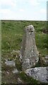
Neolithic and Bronze AgeSite Name: Glasscombe Ball North (South Cairn) Alternative Name: Grinsell Ugborough 5; Glasscomb 5; Butler (map 56.13)Country: England County: Devon Type: Cairn
Nearest Town: Ivybridge Nearest Village: Harford / Didworthy
Map Ref: SX65736041
Latitude: 50.428151N Longitude: 3.891729W
Condition:
| 5 | Perfect |
| 4 | Almost Perfect |
| 3 | Reasonable but with some damage |
| 2 | Ruined but still recognisable as an ancient site |
| 1 | Pretty much destroyed, possibly visible as crop marks |
| 0 | No data. |
| -1 | Completely destroyed |
| 5 | Superb |
| 4 | Good |
| 3 | Ordinary |
| 2 | Not Good |
| 1 | Awful |
| 0 | No data. |
| 5 | Can be driven to, probably with disabled access |
| 4 | Short walk on a footpath |
| 3 | Requiring a bit more of a walk |
| 2 | A long walk |
| 1 | In the middle of nowhere, a nightmare to find |
| 0 | No data. |
| 5 | co-ordinates taken by GPS or official recorded co-ordinates |
| 4 | co-ordinates scaled from a detailed map |
| 3 | co-ordinates scaled from a bad map |
| 2 | co-ordinates of the nearest village |
| 1 | co-ordinates of the nearest town |
| 0 | no data |
Be the first person to rate this site - see the 'Contribute!' box in the right hand menu.
Internal Links:
External Links:
I have visited· I would like to visit
Catrinm visited on 14th Apr 2024 - their rating: Cond: 2 Amb: 3 Access: 3
 (PID:206072)")
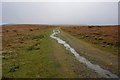
This cairn is located at the southern end of the Glasscombe Ball North stone row. It is featured on the Prehistoric Dartmoor Walks (PDW) website - see their entry for the Glasscombe Ball N.W. Cairn.
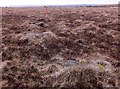
The cairn is also recorded as part of Pastscape Monument No. 441946, as part of MDV5660 (Cairn on Ugborough Moor) on the Devon and Dartmoor HER, and scheduled as part of Historic England List Entry No. 1017610 (Stone alignment and two cairns to the north-west of Glasscombe Ball). Pastscape tells us: "The south-west cairn, 4.0m. in diameter and 0.8m. high is of close-packed stones and turf-covered. It may not be associated with the row since it is off the alignment. Although Worth classifies the row as a single one a number of stones are missing or recumbent and probably mis-placed and it could have been a double row in its original state".
For more information about the stone row, see the Stone Rows of Great Britain's entry for Glasscombe Ball, North.
You may be viewing yesterday's version of this page. To see the most up to date information please register for a free account.
 (PID:206073)")
Do not use the above information on other web sites or publications without permission of the contributor.
Nearby Images from Geograph Britain and Ireland:
©2020(licence)
©2014(licence)
©2020(licence)
©2011(licence)
©2021(licence)
The above images may not be of the site on this page, they are loaded from Geograph.
Please Submit an Image of this site or go out and take one for us!
Click here to see more info for this site
Nearby sites
Key: Red: member's photo, Blue: 3rd party photo, Yellow: other image, Green: no photo - please go there and take one, Grey: site destroyed
Download sites to:
KML (Google Earth)
GPX (GPS waypoints)
CSV (Garmin/Navman)
CSV (Excel)
To unlock full downloads you need to sign up as a Contributory Member. Otherwise downloads are limited to 50 sites.
Turn off the page maps and other distractions
Nearby sites listing. In the following links * = Image available
19m N 7° Glasscombe Ball North* Stone Row / Alignment (SX6573360429)
82m NE 39° Glasscombe Ball North (North Cairn)* Cairn (SX6578360473)
227m WNW 284° Hobajons Cross* Standing Stone (Menhir) (SX65516047)
265m SW 224° Butterdon Hill Row* Stone Row / Alignment (SX6553960225)
366m NE 48° Glasscombe Corner SW Terminal Cairn* Cairn (SX6601060646)
400m NE 44° Glasscombe Corner Stone Row* Stone Row / Alignment (SX6601660691)
445m NW 316° The Longstone (Piles Hill)* Standing Stone (Menhir) (SX65436074)
475m SSE 156° Spurrell's Cross* Ancient Cross (SX65915997)
525m SSE 167° Spurrells Cross Row* Multiple Stone Rows / Avenue (SX6583759896)
538m NE 42° Glasscombe Ball NE* Multiple Stone Rows / Avenue (SX6610060802)
561m SSE 165° Spurrell's Cross Row Terminal Cairn Cairn (SX6585859864)
614m S 172° Spurrells Cross Cairn Circle* Stone Circle (SX658598)
651m NW 317° Piles Hill Cairns* Cairn (SX653609)
716m N 11° Piles Hill NE* Multiple Stone Rows / Avenue (SX65886111)
734m SW 225° Butterbrook* Stone Row / Alignment (SX652599)
779m E 82° Lower Glasscombe* Cist (SX6650660502)
809m SW 229° Harford Moor N* Stone Row / Alignment (SX651599)
876m SW 224° Harford S.* Multiple Stone Rows / Avenue (SX651598)
974m NW 314° Piles Hill W* Multiple Stone Rows / Avenue (SX65056111)
1.0km S 183° Butterdon Hill Barrow* Round Barrow(s) (SX6566059403)
1.0km ESE 113° Scad Brook* Ancient Village or Settlement (SX6667759981)
1.1km NE 35° Upper Glazebrook* Ancient Village or Settlement (SX66366126)
1.1km S 176° Butterdon Hill Cist* Cist (SX6578159341)
1.2km NE 48° Corringdon Ball* Multiple Stone Rows / Avenue (SX6660761169)
1.2km NE 46° Corringdon Ball N.* Stone Row / Alignment (SX66616121)
View more nearby sites and additional images


 We would like to know more about this location. Please feel free to add a brief description and any relevant information in your own language.
 Wir möchten mehr über diese Stätte erfahren. Bitte zögern Sie nicht, eine kurze Beschreibung und relevante Informationen in Deutsch hinzuzufügen.
 Nous aimerions en savoir encore un peu sur les lieux. S'il vous plaît n'hesitez pas à ajouter une courte description et tous les renseignements pertinents dans votre propre langue.
 Quisieramos informarnos un poco más de las lugares. No dude en añadir una breve descripción y otros datos relevantes en su propio idioma.