


<< Our Photo Pages >> Cras (Gwynedd) - Cairn in Wales in Gwynedd
Submitted by Postman on Saturday, 06 October 2012 Page Views: 2397
Neolithic and Bronze AgeSite Name: Cras (Gwynedd) Alternative Name: Cairn on ridge outcrop known as CrasCountry: Wales
NOTE: This site is 0.3 km away from the location you searched for.
County: Gwynedd Type: Cairn
Nearest Town: Bethesda
Map Ref: SH65397089
Latitude: 53.217962N Longitude: 4.017483W
Condition:
| 5 | Perfect |
| 4 | Almost Perfect |
| 3 | Reasonable but with some damage |
| 2 | Ruined but still recognisable as an ancient site |
| 1 | Pretty much destroyed, possibly visible as crop marks |
| 0 | No data. |
| -1 | Completely destroyed |
| 5 | Superb |
| 4 | Good |
| 3 | Ordinary |
| 2 | Not Good |
| 1 | Awful |
| 0 | No data. |
| 5 | Can be driven to, probably with disabled access |
| 4 | Short walk on a footpath |
| 3 | Requiring a bit more of a walk |
| 2 | A long walk |
| 1 | In the middle of nowhere, a nightmare to find |
| 0 | No data. |
| 5 | co-ordinates taken by GPS or official recorded co-ordinates |
| 4 | co-ordinates scaled from a detailed map |
| 3 | co-ordinates scaled from a bad map |
| 2 | co-ordinates of the nearest village |
| 1 | co-ordinates of the nearest town |
| 0 | no data |
Internal Links:
External Links:
 (PID:95408)")
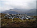
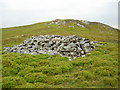
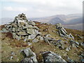
On a hill looking over Afon Rhaeadr Fawr, thats Aber falls valley, is this good cairn, good in as its still quite large , its got some kind of cist, but not a rectangular one . (see pic)
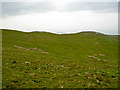
But the views are the most enjoyable part, down to the waterfalls, across to Foel Ganol with its cairns and enclosures, and weather permitting over to Anglesey and up to Y Carneddau. Bliss.
You may be viewing yesterday's version of this page. To see the most up to date information please register for a free account.
 (PID:95411)")
 (PID:95410)")
 (PID:95409)")
Do not use the above information on other web sites or publications without permission of the contributor.
Nearby Images from Geograph Britain and Ireland:
©2021(licence)
©2008(licence)
©2008(licence)
©2021(licence)

©2013(licence)
The above images may not be of the site on this page, they are loaded from Geograph.
Please Submit an Image of this site or go out and take one for us!
Click here to see more info for this site
Nearby sites
Key: Red: member's photo, Blue: 3rd party photo, Yellow: other image, Green: no photo - please go there and take one, Grey: site destroyed
Download sites to:
KML (Google Earth)
GPX (GPS waypoints)
CSV (Garmin/Navman)
CSV (Excel)
To unlock full downloads you need to sign up as a Contributory Member. Otherwise downloads are limited to 50 sites.
Turn off the page maps and other distractions
Nearby sites listing. In the following links * = Image available
269m SW 226° Cairn N of Moel Wnion* Cairn (SH65197071)
1.3km SSW 198° Moel Wnion (Gwynedd)* Cairn (SH64966971)
1.4km ESE 109° Coed Aber Roundhouse* Ancient Village or Settlement (SH6674570381)
1.7km E 88° Meuryn Isaf Cairn (SH671709)
1.8km NNE 28° Maes Y Gaer* Hillfort (SH663725)
2.1km ENE 67° Anafon Valley Cairns* Cairn (SH67397166)
2.4km ENE 66° Wern-y-Pandy Settlement* Ancient Village or Settlement (SH676718)
2.4km ENE 71° Foel Dduarth (West)* Ancient Village or Settlement (SH67717161)
2.5km SSW 210° Hut Circle at Twll Pant Hiriol* Ancient Village or Settlement (SH641688)
2.5km ENE 61° Bod-Silin Cairns* Barrow Cemetery (SH67647205)
2.6km ENE 69° Carnedd y Saeson* Cairn (SH6783471738)
2.7km ENE 70° Foel Dduarth (Centre)* Ancient Village or Settlement (SH68007174)
2.9km ENE 65° Nant y Felin-fach Cairn* Cairn (SH68027203)
3.0km ENE 68° Foel Dduarth (East)* Ancient Village or Settlement (SH68217191)
3.0km SSW 211° Bwlch ym Mhwll-le* Cairn (SH63746835)
3.0km SSE 161° Drosgl* Cairn (SH663680)
3.4km SSW 213° Moel Faban* Cairn (SH63486811)
3.5km ENE 66° Foel Ganol* Cairn (SH68597221)
3.6km SSW 209° Moel Faban Arrow Stone* Carving (SH63576780)
3.7km SW 215° Cairn cemetery, W. shoulder of Moel Faban* Cairn (SH63156789)
3.9km E 87° Afon Anafon Arrow Stone* Sculptured Stone (SH69267098)
3.9km ENE 69° Carn yr Llechwedd* Cairn (SH691722)
3.9km SW 219° Fortified hut settlement above Rachub* Hillfort (SH62826790)
4.0km WSW 245° Rhiw Goch Enclosed Hut Circle Settlement* Ancient Village or Settlement (SH61696931)
4.1km ENE 67° Ffridd Newydd Arrow stones* Rock Art (SH69237238)
View more nearby sites and additional images


 We would like to know more about this location. Please feel free to add a brief description and any relevant information in your own language.
 Wir möchten mehr über diese Stätte erfahren. Bitte zögern Sie nicht, eine kurze Beschreibung und relevante Informationen in Deutsch hinzuzufügen.
 Nous aimerions en savoir encore un peu sur les lieux. S'il vous plaît n'hesitez pas à ajouter une courte description et tous les renseignements pertinents dans votre propre langue.
 Quisieramos informarnos un poco más de las lugares. No dude en añadir una breve descripción y otros datos relevantes en su propio idioma.