 with our Megalithic Portal iPhone app")

<< Text Pages >> Penrhyncoch War Memorial - Standing Stone (Menhir) in Wales in Ceredigion
Submitted by ESgt on Thursday, 16 April 2015 Page Views: 2661
Neolithic and Bronze AgeSite Name: Penrhyncoch War Memorial Alternative Name: Banc Troed Rhiw Seiri StoneCountry: Wales County: Ceredigion Type: Standing Stone (Menhir)
Nearest Town: Aberystwyth Nearest Village: Penrhyncoch
Map Ref: SN6422984058
Latitude: 52.437580N Longitude: 3.998716W
Condition:
| 5 | Perfect |
| 4 | Almost Perfect |
| 3 | Reasonable but with some damage |
| 2 | Ruined but still recognisable as an ancient site |
| 1 | Pretty much destroyed, possibly visible as crop marks |
| 0 | No data. |
| -1 | Completely destroyed |
| 5 | Superb |
| 4 | Good |
| 3 | Ordinary |
| 2 | Not Good |
| 1 | Awful |
| 0 | No data. |
| 5 | Can be driven to, probably with disabled access |
| 4 | Short walk on a footpath |
| 3 | Requiring a bit more of a walk |
| 2 | A long walk |
| 1 | In the middle of nowhere, a nightmare to find |
| 0 | No data. |
| 5 | co-ordinates taken by GPS or official recorded co-ordinates |
| 4 | co-ordinates scaled from a detailed map |
| 3 | co-ordinates scaled from a bad map |
| 2 | co-ordinates of the nearest village |
| 1 | co-ordinates of the nearest town |
| 0 | no data |
Internal Links:
External Links:
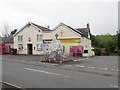
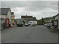
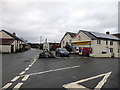
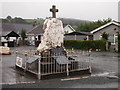
Possible Standing Stone in Ceredigion, now a WWI & WWII war memorial and topped with a cross.
It's a white quartz stone monument fenced off in the middle of the road junction at Penrhyn-coch. Source: Anthony Pugh
Laying on an alignment from the hill of Parcgwyn, through Ponterwyd Chapel, across the Settlements of Banc-y-Darren and the one above Bow Street, then onto the Sarn Cynfelyn at Wallog. That's where the people of Cantref Gwaelod escaped up from the flood; legend has it.
But The Modern Antiquarian references a 1939 thesis by AR Sainsbury, which I believe to be held in the RCAHMW library claiming it was moved from SN66138586, [update from comments - Ed] a distance of 2.7km, which ESgt thinks is unlikely.
You may be viewing yesterday's version of this page. To see the most up to date information please register for a free account.
Do not use the above information on other web sites or publications without permission of the contributor.
Nearby Images from Geograph Britain and Ireland:
©2021(licence)
©2009(licence)
©2018(licence)
©2018(licence)
©2021(licence)
The above images may not be of the site on this page, they are loaded from Geograph.
Please Submit an Image of this site or go out and take one for us!
Click here to see more info for this site
Nearby sites
Key: Red: member's photo, Blue: 3rd party photo, Yellow: other image, Green: no photo - please go there and take one, Grey: site destroyed
Download sites to:
KML (Google Earth)
GPX (GPS waypoints)
CSV (Garmin/Navman)
CSV (Excel)
To unlock full downloads you need to sign up as a Contributory Member. Otherwise downloads are limited to 50 sites.
Turn off the page maps and other distractions
Nearby sites listing. In the following links * = Image available
918m E 88° Bryntirion Well* Holy Well or Sacred Spring (SN65158407)
978m N 5° Cwrt Enclosure Ancient Village or Settlement (SN64348503)
987m WNW 289° Hen Gaer Hillfort (SN633844)
1.7km WSW 248° Plas Gogerddan Barrow* Round Barrow(s) (SN62658348)
1.7km WSW 249° Plas Gogerddan* Stone Row / Alignment (SN626835)
1.8km W 262° Gorgerddan Enclosure Ancient Village or Settlement (SN62418387)
1.9km WSW 259° Gorgerddan Round Barrow(s) (SN62328373)
2.0km W 276° Bow Street* Ancient Village or Settlement (SN6223584325)
2.9km NW 308° Ruel Uchaf Ancient Village or Settlement (SN620859)
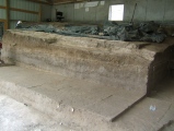
3.0km ENE 58° Banc Troed Rhiw Seiri* Ring Cairn (SN6679385583)
3.4km NW 324° St Michael's Church Well Holy Well or Sacred Spring (SN62328687)
3.8km ESE 104° Darren Camp Cairn II Cairn (SN6789183010)
3.8km ESE 105° Darren Camp Cairn I Cairn (SN6789382997)
3.8km ESE 104° Darren Camp* Hillfort (SN67908302)
4.0km E 99° Cwm-Y-Darren and Twyll-Y-Mwyn Copper Mines Ancient Mine, Quarry or other Industry (SN68148335)
4.3km E 86° Garn Wen Barrow Cairn (SN68518421)
4.3km E 94° Stones of the Lamb* Standing Stone (Menhir) (SN68568367)
4.5km E 85° Garn Wen (NE) Cairn (SN68788436)
4.8km E 79° Pen-Y-Castell Hillfort Hillfort (SN68958480)
5.0km E 79° Pen-Y-Castell* Standing Stone (Menhir) (SN69138487)
5.3km SW 232° Y Garreg Fawr* Chambered Tomb (SN59998093)
5.3km SW 233° Llanbadarn Fawr Celtic Crosses* Ancient Cross (SN59918101)
5.5km WSW 238° Ffynnon Badarn* Holy Well or Sacred Spring (SN5951181263)
5.6km WNW 298° Cerig Y Gath Burial Chamber or Dolmen (SN59378678)
5.8km E 88° Pen-Y-Bryn-Mawr Cairn (SN70018412)
View more nearby sites and additional images


 We would like to know more about this location. Please feel free to add a brief description and any relevant information in your own language.
 Wir möchten mehr über diese Stätte erfahren. Bitte zögern Sie nicht, eine kurze Beschreibung und relevante Informationen in Deutsch hinzuzufügen.
 Nous aimerions en savoir encore un peu sur les lieux. S'il vous plaît n'hesitez pas à ajouter une courte description et tous les renseignements pertinents dans votre propre langue.
 Quisieramos informarnos un poco más de las lugares. No dude en añadir una breve descripción y otros datos relevantes en su propio idioma.