


<< Our Photo Pages >> Essich Moor - Chambered Cairn in Scotland in Highlands
Submitted by Spindrift on Tuesday, 19 June 2018 Page Views: 8238
Neolithic and Bronze AgeSite Name: Essich Moor Alternative Name: Carn GlasCountry: Scotland
NOTE: This site is 3.0 km away from the location you searched for.
County: Highlands Type: Chambered Cairn
Nearest Town: Inverness
Map Ref: NH649383 Landranger Map Number: 26
Latitude: 57.414927N Longitude: 4.250861W
Condition:
| 5 | Perfect |
| 4 | Almost Perfect |
| 3 | Reasonable but with some damage |
| 2 | Ruined but still recognisable as an ancient site |
| 1 | Pretty much destroyed, possibly visible as crop marks |
| 0 | No data. |
| -1 | Completely destroyed |
| 5 | Superb |
| 4 | Good |
| 3 | Ordinary |
| 2 | Not Good |
| 1 | Awful |
| 0 | No data. |
| 5 | Can be driven to, probably with disabled access |
| 4 | Short walk on a footpath |
| 3 | Requiring a bit more of a walk |
| 2 | A long walk |
| 1 | In the middle of nowhere, a nightmare to find |
| 0 | No data. |
| 5 | co-ordinates taken by GPS or official recorded co-ordinates |
| 4 | co-ordinates scaled from a detailed map |
| 3 | co-ordinates scaled from a bad map |
| 2 | co-ordinates of the nearest village |
| 1 | co-ordinates of the nearest town |
| 0 | no data |
Internal Links:
External Links:
I have visited· I would like to visit
TheCaptain has visited here
")
This is from the NOSAS Facebook page: "We were very sorry to learn today that one of the cists at Carn Glas long cairn, Achvraid, Essich, south of Inverness has been deliberately damaged. This is a scheduled monument and the police, HES and Highland Council are aware. Let's hope an example can be made of the perpetrators.
Source: Prehistoric Explorers Club Facebook page. If anyone has any information on who is behind this please report!
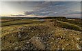
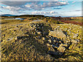
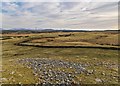
Cairns mostly destroyed but at least 3 small exposed chambers can be seen. The southmost cairn is in the best condition with its chamber right on the summit.
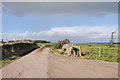
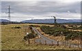
Parking for a short visit is possible near the cattlegrid almost under the power lines or near gate 200 m further north-west. Cairns are in a field reached after negotiating some boggy ground. Livestock often present so it could be worth getting permission first.
Read More at Canmore.
You may be viewing yesterday's version of this page. To see the most up to date information please register for a free account.
")
")
")
")
Do not use the above information on other web sites or publications without permission of the contributor.
Nearby Images from Geograph Britain and Ireland:
©2017(licence)
©2016(licence)
©2020(licence)
©2010(licence)
©2017(licence)
The above images may not be of the site on this page, they are loaded from Geograph.
Please Submit an Image of this site or go out and take one for us!
Click here to see more info for this site
Nearby sites
Key: Red: member's photo, Blue: 3rd party photo, Yellow: other image, Green: no photo - please go there and take one, Grey: site destroyed
Download sites to:
KML (Google Earth)
GPX (GPS waypoints)
CSV (Garmin/Navman)
CSV (Excel)
To unlock full downloads you need to sign up as a Contributory Member. Otherwise downloads are limited to 50 sites.
Turn off the page maps and other distractions
Nearby sites listing. In the following links * = Image available
2.2km NNW 344° Torbreck* Stone Circle (NH64384039)
2.8km WNW 282° Kinchyle Of Dores* Stone Circle (NH62153898)
3.0km ESE 105° Tomfat Plantation* Chambered Cairn (NH678374)
3.8km SE 127° Gask Henge* Henge (NH67833590)
3.9km SE 127° Gask Cairn* Ring Cairn (NH6794435860)
5.2km NE 42° Druidtemple* Stone Circle (NH685420)
5.5km WSW 242° Aldourie* Ring Cairn (NH59993587)
5.6km SE 146° Tordarroch cup-marked stone* Rock Art (NH679336)
5.7km NNW 330° Ladystone Farm* Stone Row / Alignment (NH62204330)
5.7km SE 145° Tordarroch Cairn* Clava Cairn (NH68013349)
5.9km S 185° Eastertown Cairn* Cairn (NH64203245)
6.2km SE 144° Croftcroy Stone Circle* Stone Circle (NH6835133191)
6.2km NNW 340° Leachkin* Chambered Cairn (NH62964416)
6.2km SE 145° Croftcroy Chambered Tomb Chambered Tomb (NH683331)
6.3km SSW 204° West Town* Chambered Cairn (NH62173258)
6.6km N 9° Knocknagael* Class I Pictish Symbol Stone (NH662448)
6.6km E 101° Midlairgs Stone Circle (NH714368)
6.9km N 351° Craig Phadraig* Vitrified Fort (NH640452)
7.0km NNE 17° Broad Stone Early Christian Sculptured Stone (NH672449)
7.1km NNE 13° Inverness Museum* Museum (NH66684519)
7.1km NNE 13° Clach-na-Crudainn* Standing Stone (Menhir) (NH66684521)
7.5km NNE 31° Essich House Class I Pictish Symbol Stone (NH69004456)
7.8km NNE 28° Raigmore* Clava Cairn (NH6878445083)
8.0km NNE 29° Beechwood Farm Site Ancient Mine, Quarry or other Industry (NH6908045190)
8.3km ENE 68° Daviot Ring Cairn* Stone Circle (NH727411)
View more nearby sites and additional images


 We would like to know more about this location. Please feel free to add a brief description and any relevant information in your own language.
 Wir möchten mehr über diese Stätte erfahren. Bitte zögern Sie nicht, eine kurze Beschreibung und relevante Informationen in Deutsch hinzuzufügen.
 Nous aimerions en savoir encore un peu sur les lieux. S'il vous plaît n'hesitez pas à ajouter une courte description et tous les renseignements pertinents dans votre propre langue.
 Quisieramos informarnos un poco más de las lugares. No dude en añadir una breve descripción y otros datos relevantes en su propio idioma.