

<< Our Photo Pages >> Din Sylwy - Hillfort in Wales in Anglesey
Submitted by vicky on Tuesday, 24 September 2002 Page Views: 15576
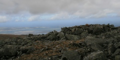
Iron Age and Later PrehistorySite Name: Din Sylwy Alternative Name: Bwrdd ArthurCountry: Wales County: Anglesey Type: Hillfort
Nearest Village: Llanfihangel-Din-Syl
Map Ref: SH586815 Landranger Map Number: 114
Latitude: 53.311502N Longitude: 4.12382W
Condition:
| 5 | Perfect |
| 4 | Almost Perfect |
| 3 | Reasonable but with some damage |
| 2 | Ruined but still recognisable as an ancient site |
| 1 | Pretty much destroyed, possibly visible as crop marks |
| 0 | No data. |
| -1 | Completely destroyed |
| 5 | Superb |
| 4 | Good |
| 3 | Ordinary |
| 2 | Not Good |
| 1 | Awful |
| 0 | No data. |
| 5 | Can be driven to, probably with disabled access |
| 4 | Short walk on a footpath |
| 3 | Requiring a bit more of a walk |
| 2 | A long walk |
| 1 | In the middle of nowhere, a nightmare to find |
| 0 | No data. |
| 5 | co-ordinates taken by GPS or official recorded co-ordinates |
| 4 | co-ordinates scaled from a detailed map |
| 3 | co-ordinates scaled from a bad map |
| 2 | co-ordinates of the nearest village |
| 1 | co-ordinates of the nearest town |
| 0 | no data |
Internal Links:
External Links:
I have visited· I would like to visit
PAB has visited here
")
You may be viewing yesterday's version of this page. To see the most up to date information please register for a free account.
")
")
")
")
")
")
")
")
")
Do not use the above information on other web sites or publications without permission of the contributor.
Click here to see more info for this site
Nearby sites
Key: Red: member's photo, Blue: 3rd party photo, Yellow: other image, Green: no photo - please go there and take one, Grey: site destroyed
Download sites to:
KML (Google Earth)
GPX (GPS waypoints)
CSV (Garmin/Navman)
CSV (Excel)
To unlock full downloads you need to sign up as a Contributory Member. Otherwise downloads are limited to 50 sites.
Turn off the page maps and other distractions
Nearby sites listing. In the following links * = Image available
2.6km SW 223° Llanddona* Standing Stone (Menhir) (SH5675879673)
4.0km ESE 106° Penmon Park Settlement Ancient Village or Settlement (SH6241280315)
4.1km SSW 198° Cremlyn 1* Standing Stone (Menhir) (SH572776)
4.2km E 95° Tyddyn Rheinallt Settlement Ancient Village or Settlement (SH6275580995)
4.3km SSW 196° Cremlyn 2* Standing Stone (Menhir) (SH573774)
4.3km E 93° Penmon Deer Park Settlement Ancient Village or Settlement (SH6290981114)
4.5km E 99° Penmon Priory and Church* Ancient Cross (SH630807)
4.5km ESE 108° Tan-Y-Fron* Ancient Village or Settlement (SH6284479994)
4.5km E 97° St Seiriol's Well* Holy Well or Sacred Spring (SH631808)
5.4km WSW 251° Traeth Coch Pentraeth Standing Stone* Marker Stone (SH534799)
5.5km SW 218° Hendrefor* Chambered Tomb (SH551773)
5.6km WSW 236° Mynydd Llwydiarth Hillfort (SH5378978520)
5.8km SSE 157° Anglesey Eisteddfod Circle* Modern Stone Circle etc (SH607761)
6.5km WSW 240° The Three Leaps* Stone Row / Alignment (SH5283878407)
6.8km W 274° Caru Benllech Mini Cromlech (modern)* Modern Stone Circle etc (SH5178782173)
6.9km W 277° Benllech Chambered Tomb Chambered Tomb (SH518825)
7.2km W 270° Coed y Glyn Burial Chamber* Chambered Tomb (SH5141381728)
7.7km W 275° Pant-Y-Saer* Chambered Tomb (SH5097182401)
7.9km SSW 194° Pen-Y-Maen* Standing Stone (Menhir) (SH564739)
8.0km W 278° St Mary (Tynygongl) Ancient Cross (SH50658290)
8.2km SSW 201° Ty-Gwyn* Standing Stone (Menhir) (SH5536273949)
8.3km WSW 247° Llanddyfynan Barrows* Chambered Tomb (SH5088278462)
8.8km S 183° Gorsedd Stones, Bangor* Modern Stone Circle etc (SH5785272766)
8.9km WSW 249° Llanddfynan Standing Stone* Standing Stone (Menhir) (SH5014978592)
9.0km WNW 289° Cae Marh Ancient Village or Settlement (SH5016784694)
View more nearby sites and additional images


 We would like to know more about this location. Please feel free to add a brief description and any relevant information in your own language.
 Wir möchten mehr über diese Stätte erfahren. Bitte zögern Sie nicht, eine kurze Beschreibung und relevante Informationen in Deutsch hinzuzufügen.
 Nous aimerions en savoir encore un peu sur les lieux. S'il vous plaît n'hesitez pas à ajouter une courte description et tous les renseignements pertinents dans votre propre langue.
 Quisieramos informarnos un poco más de las lugares. No dude en añadir una breve descripción y otros datos relevantes en su propio idioma.