


<< Our Photo Pages >> Mains of Kilcoy SE - Cairn in Scotland in Highlands
Submitted by markj99 on Wednesday, 23 December 2020 Page Views: 379
Neolithic and Bronze AgeSite Name: Mains of Kilcoy SECountry: Scotland County: Highlands Type: Cairn
Nearest Town: Inverness Nearest Village: Tore
Map Ref: NH57765186
Latitude: 57.534447N Longitude: 4.377514W
Condition:
| 5 | Perfect |
| 4 | Almost Perfect |
| 3 | Reasonable but with some damage |
| 2 | Ruined but still recognisable as an ancient site |
| 1 | Pretty much destroyed, possibly visible as crop marks |
| 0 | No data. |
| -1 | Completely destroyed |
| 5 | Superb |
| 4 | Good |
| 3 | Ordinary |
| 2 | Not Good |
| 1 | Awful |
| 0 | No data. |
| 5 | Can be driven to, probably with disabled access |
| 4 | Short walk on a footpath |
| 3 | Requiring a bit more of a walk |
| 2 | A long walk |
| 1 | In the middle of nowhere, a nightmare to find |
| 0 | No data. |
| 5 | co-ordinates taken by GPS or official recorded co-ordinates |
| 4 | co-ordinates scaled from a detailed map |
| 3 | co-ordinates scaled from a bad map |
| 2 | co-ordinates of the nearest village |
| 1 | co-ordinates of the nearest town |
| 0 | no data |
Internal Links:
External Links:
")
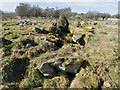
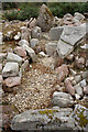
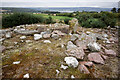
There is a pair of cairns located within 250m of Carn Glas (Mains of Kilcoy). Mains of Kilcoy SE is the more impressive of the pair, looking like a long cairn. However only one cist was visible on the surface, an off-centre shallow cist measuring c. 1m x 0.5m. According to Canmore ID 12840 the centre of this c. 30m cairn was excavated but no cist or chamber were found. It does seem to be a contradiction; all this construction for one shallow burial.
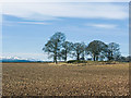
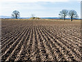
I visited Mains of Kilcoy in 2012 after visiting Carn Glas (Mains of Kilcoy). Mains of Kilcoy SE is c. 250m SSE of Carn Glas. The field was ploughed and the Mains of Kilcoy cairns were verdant islands in a dark sea.
You may be viewing yesterday's version of this page. To see the most up to date information please register for a free account.
")
")
")
Do not use the above information on other web sites or publications without permission of the contributor.
Nearby Images from Geograph Britain and Ireland:
©2014(licence)
©2014(licence)
©2014(licence)
©2023(licence)
©2023(licence)
The above images may not be of the site on this page, they are loaded from Geograph.
Please Submit an Image of this site or go out and take one for us!
Click here to see more info for this site
Nearby sites
Key: Red: member's photo, Blue: 3rd party photo, Yellow: other image, Green: no photo - please go there and take one, Grey: site destroyed
Download sites to:
KML (Google Earth)
GPX (GPS waypoints)
CSV (Garmin/Navman)
CSV (Excel)
To unlock full downloads you need to sign up as a Contributory Member. Otherwise downloads are limited to 50 sites.
Turn off the page maps and other distractions
Nearby sites listing. In the following links * = Image available
64m NW 319° Mains of Kilcoy NW* Cairn (NH57725191)
145m NNE 14° Carn Glas* Chambered Cairn (NH578520)
774m WSW 256° Kilcoy North Chambered Tomb (NH570517)
838m WSW 243° Kilcoy South* Chambered Tomb (NH570515)
1.2km WNW 289° Carn Urnan* Stone Circle (NH5666252289)
1.9km WNW 288° Cairnside Chambered Tomb (NH560525)
2.8km WNW 283° Muir of Allangrange* Chambered Cairn (NH55005259)
3.2km W 278° Muir of Conan Chambered Cairn (NH546524)
3.6km SW 231° Tarradale* Chambered Tomb (NH549497)
3.7km W 281° Bishop Kinkell Chambered Cairn (NH541527)
3.8km W 269° Balvaird Chambered Cairn (NH53945193)
4.1km ENE 77° The Temple (Tore)* Chambered Tomb (NH6179952610)
4.7km NW 311° Conon Bridge* Henge (NH54295507)
4.9km N 357° Mulchaich* Cairn (NH57665679)
5.5km WSW 245° Muir of Ord Henge* Henge (NH527497)
5.8km ENE 58° Balnaguie* Chambered Cairn (NH62835473)
5.9km SW 230° Windhill* Standing Stones (NH531482)
6.6km ENE 72° Cloutie Well* Holy Well or Sacred Spring (NH641537)
6.6km NW 312° Ussie Chambered Cairn* Chambered Cairn (NH530565)
7.6km NNW 336° Dingwall* Class I Pictish Symbol Stone (NH54935893)
7.9km ENE 56° Belmaduthy* Chambered Cairn (NH6447255983)
8.1km WNW 292° Brahan Wood* Chambered Cairn (NH504552)
8.4km S 191° Giant's Grave (Highlands) Chambered Cairn (NH55904369)
8.7km SSW 195° Balblair Class I Pictish Symbol Stone (NH55184357)
9.1km SE 135° Craig Phadraig* Vitrified Fort (NH640452)
View more nearby sites and additional images


 We would like to know more about this location. Please feel free to add a brief description and any relevant information in your own language.
 Wir möchten mehr über diese Stätte erfahren. Bitte zögern Sie nicht, eine kurze Beschreibung und relevante Informationen in Deutsch hinzuzufügen.
 Nous aimerions en savoir encore un peu sur les lieux. S'il vous plaît n'hesitez pas à ajouter une courte description et tous les renseignements pertinents dans votre propre langue.
 Quisieramos informarnos un poco más de las lugares. No dude en añadir una breve descripción y otros datos relevantes en su propio idioma.