


<< Our Photo Pages >> Trowlesworthy Tor settlement - Ancient Village or Settlement in England in Devon
Submitted by TheCaptain on Wednesday, 22 May 2013 Page Views: 2271
Multi-periodSite Name: Trowlesworthy Tor settlement Alternative Name: Trowlesworthy WarrenCountry: England County: Devon Type: Ancient Village or Settlement
Nearest Town: Plymouth
Map Ref: SX57506445
Latitude: 50.462520N Longitude: 4.009062W
Condition:
| 5 | Perfect |
| 4 | Almost Perfect |
| 3 | Reasonable but with some damage |
| 2 | Ruined but still recognisable as an ancient site |
| 1 | Pretty much destroyed, possibly visible as crop marks |
| 0 | No data. |
| -1 | Completely destroyed |
| 5 | Superb |
| 4 | Good |
| 3 | Ordinary |
| 2 | Not Good |
| 1 | Awful |
| 0 | No data. |
| 5 | Can be driven to, probably with disabled access |
| 4 | Short walk on a footpath |
| 3 | Requiring a bit more of a walk |
| 2 | A long walk |
| 1 | In the middle of nowhere, a nightmare to find |
| 0 | No data. |
| 5 | co-ordinates taken by GPS or official recorded co-ordinates |
| 4 | co-ordinates scaled from a detailed map |
| 3 | co-ordinates scaled from a bad map |
| 2 | co-ordinates of the nearest village |
| 1 | co-ordinates of the nearest town |
| 0 | no data |
Internal Links:
External Links:
I have visited· I would like to visit
Catrinm visited on 29th Jan 2022 - their rating: Cond: 2 Amb: 4 Access: 3 Very recognisable buildings - is it iron age or earlier
TheCaptain have visited here
")
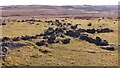
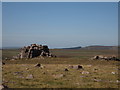
Some of the higher remains, above the Lee Moor clay works leat are in very good condition, and it can be seen that much of the enclosure walling consists of double faced walling made with some very large slabs.
Update December 2019: This site is featured on the Prehistoric Dartmoor Walks (PDW) website - see their entries for the Trowlesworthy Warren Enclosed Settlement and the Trowlesworthy, Settlements, Stone Row & Cairn Circle.
This settlement is also recorded as Pastscape Monument No. 439142, as MDV2507 (Prehistoric Settlement (G) near Trowlesworthy Tor, Shaugh Prior) on the Devon and Dartmoor HER, and scheduled as part of Historic England List Entry No. 1019084 (Partially enclosed stone hut circle settlement and post-medieval warren structures on the western slope of Little and Great Trowlesworthy Tors).
You may be viewing yesterday's version of this page. To see the most up to date information please register for a free account.
")
")
Do not use the above information on other web sites or publications without permission of the contributor.
Nearby Images from Geograph Britain and Ireland:
©2022(licence)
©2009(licence)
©2009(licence)
©2014(licence)
©2012(licence)
The above images may not be of the site on this page, they are loaded from Geograph.
Please Submit an Image of this site or go out and take one for us!
Click here to see more info for this site
Nearby sites
Key: Red: member's photo, Blue: 3rd party photo, Yellow: other image, Green: no photo - please go there and take one, Grey: site destroyed
Download sites to:
KML (Google Earth)
GPX (GPS waypoints)
CSV (Garmin/Navman)
CSV (Excel)
To unlock full downloads you need to sign up as a Contributory Member. Otherwise downloads are limited to 50 sites.
Turn off the page maps and other distractions
Nearby sites listing. In the following links * = Image available
103m NNW 329° Trowlesworthy Tor north settlement* Ancient Village or Settlement (SX5745064540)
473m S 172° Trowlesworthy West circle* Stone Circle (SX57556398)
473m NW 311° Trowlesworthy Warren Cairn (SX57156477)
482m S 183° Trowlesworthy West row* Stone Row / Alignment (SX57466397)
493m SSE 161° Trowlesworthy East circle* Stone Circle (SX57656398)
515m S 186° Trowlesworthy West enclosure* Ring Cairn (SX57436394)
559m SSE 168° Trowlesworthy* Barrow Cemetery (SX57606390)
631m SSE 168° Trowlesworthy East row* Multiple Stone Rows / Avenue (SX57626383)
901m NNW 339° Legis Tor Enclosures* Ancient Village or Settlement (SX572653)
989m NE 42° Willing Walls Warren Ring Cairn Ring Cairn (SX58186517)
1.0km N 3° Legis Tor Ossuary* Cist (SX5757365470)
1.0km N 352° Legis Tor Cairns* Cist (SX57396548)
1.0km E 88° Upper Spanish Lake* Cist (SX58546445)
1.0km NE 42° Willing Walls Reave Ring Cairn (SX58226520)
1.1km WNW 300° Shadyback Tor settlement* Ancient Village or Settlement (SX566650)
1.1km NE 43° Willing Walls Warren Cairn Circle* Cairn (SX5826665227)
1.1km N 358° Legis Tor East* Cairn (SX57496554)
1.1km SE 129° Hanging Stone (Lee Moor)* Standing Stone (Menhir) (SX58376371)
1.2km SE 130° Lee Moor South* Stone Row / Alignment (SX5835963682)
1.2km NE 40° Lee Moor (Willings Walls) Cist* Cist (SX58286534)
1.4km NW 316° Ringmoor Down Cairn 1* Cairn (SX56566549)
1.5km NW 314° Brisworthy* Stone Circle (SX5646765489)
1.5km SE 128° Shell Top Chambered Cairn* Cairn (SX58666349)
1.5km NNE 33° Ditsworthy Circle* Cairn (SX58376570)
1.6km SE 135° Lee Moor Settlement* Ancient Village or Settlement (SX586633)
View more nearby sites and additional images


 We would like to know more about this location. Please feel free to add a brief description and any relevant information in your own language.
 Wir möchten mehr über diese Stätte erfahren. Bitte zögern Sie nicht, eine kurze Beschreibung und relevante Informationen in Deutsch hinzuzufügen.
 Nous aimerions en savoir encore un peu sur les lieux. S'il vous plaît n'hesitez pas à ajouter une courte description et tous les renseignements pertinents dans votre propre langue.
 Quisieramos informarnos un poco más de las lugares. No dude en añadir una breve descripción y otros datos relevantes en su propio idioma.