


<< Our Photo Pages >> Plas Llyn Settlement - Ancient Village or Settlement in Wales in Gwynedd
Submitted by TAlanJones on Thursday, 07 March 2024 Page Views: 47
Multi-periodSite Name: Plas Llyn Settlement Alternative Name: Braich y Gornel SettlementCountry: Wales County: Gwynedd Type: Ancient Village or Settlement
Nearest Town: Porthmadog Nearest Village: Dolbenmaen
Map Ref: SH5566945399
Latitude: 52.986432N Longitude: 4.151501W
Condition:
| 5 | Perfect |
| 4 | Almost Perfect |
| 3 | Reasonable but with some damage |
| 2 | Ruined but still recognisable as an ancient site |
| 1 | Pretty much destroyed, possibly visible as crop marks |
| 0 | No data. |
| -1 | Completely destroyed |
| 5 | Superb |
| 4 | Good |
| 3 | Ordinary |
| 2 | Not Good |
| 1 | Awful |
| 0 | No data. |
| 5 | Can be driven to, probably with disabled access |
| 4 | Short walk on a footpath |
| 3 | Requiring a bit more of a walk |
| 2 | A long walk |
| 1 | In the middle of nowhere, a nightmare to find |
| 0 | No data. |
| 5 | co-ordinates taken by GPS or official recorded co-ordinates |
| 4 | co-ordinates scaled from a detailed map |
| 3 | co-ordinates scaled from a bad map |
| 2 | co-ordinates of the nearest village |
| 1 | co-ordinates of the nearest town |
| 0 | no data |
Internal Links:
External Links:
")
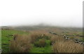
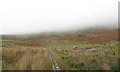
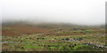
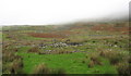
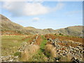
Situated within an eastern sloping field to the west of Llyn Ystradllyn the settlement comprises of a single hut circle and an adjoined enclosure. There are ancient field boundaries within the more modern field that may be contemporary but this post's focus is the hut circle. Coflein has recorded the settlement as 288295.
The hut is about 5m in diameter and currently overgrown with marsh grass mainly central and on the western side. However, the walling on the NE side is a visible arc but it has tumbled creating a scree/rubble of medium sized stones. The adjoing enclosure is a tapered rectangle 14m long by 7m at its widest. The stone walling is fragmented but definable.
A footpath passes about 40m to the east with a style crossing the modern dry stone walls. The footpath leads to/from the deserted quarry village of Treforys to the NE.
NB: Treforys village was established by Robert Gill & John Harris to house slate quarrymen at their Gorseddau Quarry, Cwm Ystradllyn. After securing sponsorship of £125,000 to 'make their fortune' via the slate industry (inspired by the successes of Blaenau Ffestiniog and Penrhyn quarries) they secured the right to quarry for £2000 in 1845. By 1861 the village had 36 cottages and supporting services along three long stone walled streets. The quarry went bust and closed owing thousands in 1867. The village lingered for a bit longer but was totally abandoned by 1871.
You may be viewing yesterday's version of this page. To see the most up to date information please register for a free account.
")
")
")
Do not use the above information on other web sites or publications without permission of the contributor.
Nearby Images from Geograph Britain and Ireland:
©2006(licence)
©2006(licence)
©2006(licence)
©2006(licence)
©2006(licence)
The above images may not be of the site on this page, they are loaded from Geograph.
Please Submit an Image of this site or go out and take one for us!
Click here to see more info for this site
Nearby sites
Key: Red: member's photo, Blue: 3rd party photo, Yellow: other image, Green: no photo - please go there and take one, Grey: site destroyed
Download sites to:
KML (Google Earth)
GPX (GPS waypoints)
CSV (Garmin/Navman)
CSV (Excel)
To unlock full downloads you need to sign up as a Contributory Member. Otherwise downloads are limited to 50 sites.
Turn off the page maps and other distractions
Nearby sites listing. In the following links * = Image available
104m SSE 161° Hut Circle Settlement West of Treforys deserted quarry village* Ancient Village or Settlement (SH557453)
118m ENE 68° Plas Llyn Mound* Artificial Mound (SH5578045440)
204m NW 304° Cairn North of Braich y Gornel Cairn (SH5550345518)
234m W 260° Braich Y Gornel Enclosure* Ancient Village or Settlement (SH5543745364)
336m WSW 250° Cist North of Braich y Gornel* Cist (SH5535045292)
345m W 273° Cist SW of Moel Hebog* Cist (SH5532445429)
388m NW 308° Hut Circle West of Moel Hebog* Ancient Village or Settlement (SH5536845645)
573m SSW 208° Cwm Ystradllyn Cairn 1* Cairn (SH5538744899)
594m SW 231° Braich y Gornel Summit Stone Feature* Natural Stone / Erratic / Other Natural Feature (SH5519445040)
603m W 271° Hut Circle SW of Moel Hebog* Ancient Village or Settlement (SH5506545427)
636m W 273° Cairn Moel Hebog W Slopes* Cairn (SH5503345451)
668m SW 232° Braich y Gornel cairn* Cairn (SH5512845004)
783m SSW 199° Cwm Ystradllyn Cairn 3* Cairn (SH5539544665)
787m SSW 199° Cwm Ystradllyn Cairn 2* Cairn (SH5538644664)
799m SE 137° Hut Circle Settlement East of Cefn Bifor* Ancient Village or Settlement (SH562448)
829m E 90° Hut Circle East of Plas Llyn* Ancient Village or Settlement (SH5650045370)
835m E 81° Hut Circle North of Ffridd Isaf* Ancient Village or Settlement (SH565455)
835m ENE 78° Cwm Ystradllyn possible Cairn with Capstone* Cairn (SH5649445544)
838m E 80° Cwm Ystradllyn Cairn Cemetery* Barrow Cemetery (SH5650045525)
838m ENE 78° Cwm Ystradllyn Stone Alignment* Stone Row / Alignment (SH5649745545)
841m SSW 212° Braich Y Gornel Settlement* Ancient Village or Settlement (SH552447)
842m SSW 197° Single Hut Circle East of Braich Y Gornel* Ancient Village or Settlement (SH554446)
887m E 86° Ancient field Systems East of Plas Llyn* Ancient Village or Settlement (SH5655845428)
896m SW 226° Hut Circles at Braich Y Gornel * Ancient Village or Settlement (SH550448)
910m SSW 206° Cwm Ystradllyn Hut Circle Settlement* Ancient Village or Settlement (SH5524044595)
View more nearby sites and additional images


 We would like to know more about this location. Please feel free to add a brief description and any relevant information in your own language.
 Wir möchten mehr über diese Stätte erfahren. Bitte zögern Sie nicht, eine kurze Beschreibung und relevante Informationen in Deutsch hinzuzufügen.
 Nous aimerions en savoir encore un peu sur les lieux. S'il vous plaît n'hesitez pas à ajouter une courte description et tous les renseignements pertinents dans votre propre langue.
 Quisieramos informarnos un poco más de las lugares. No dude en añadir una breve descripción y otros datos relevantes en su propio idioma.