


<< Our Photo Pages >> Sallachadh Broch - Broch or Nuraghe in Scotland in Highlands
Submitted by cosmic on Tuesday, 25 January 2005 Page Views: 5832
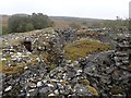
Iron Age and Later PrehistorySite Name: Sallachadh Broch Alternative Name: Sallachy BrochCountry: Scotland County: Highlands Type: Broch or Nuraghe
Nearest Town: Lairg
Map Ref: NC549092
Latitude: 58.048104N Longitude: 4.460018W
Condition:
| 5 | Perfect |
| 4 | Almost Perfect |
| 3 | Reasonable but with some damage |
| 2 | Ruined but still recognisable as an ancient site |
| 1 | Pretty much destroyed, possibly visible as crop marks |
| 0 | No data. |
| -1 | Completely destroyed |
| 5 | Superb |
| 4 | Good |
| 3 | Ordinary |
| 2 | Not Good |
| 1 | Awful |
| 0 | No data. |
| 5 | Can be driven to, probably with disabled access |
| 4 | Short walk on a footpath |
| 3 | Requiring a bit more of a walk |
| 2 | A long walk |
| 1 | In the middle of nowhere, a nightmare to find |
| 0 | No data. |
| 5 | co-ordinates taken by GPS or official recorded co-ordinates |
| 4 | co-ordinates scaled from a detailed map |
| 3 | co-ordinates scaled from a bad map |
| 2 | co-ordinates of the nearest village |
| 1 | co-ordinates of the nearest town |
| 0 | no data |
Internal Links:
External Links:
")
You may be viewing yesterday's version of this page. To see the most up to date information please register for a free account.
")
")
")
Do not use the above information on other web sites or publications without permission of the contributor.
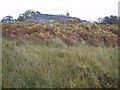
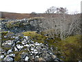
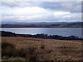
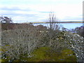
Nearby Images from Geograph Britain and Ireland:
©2005(licence)
©2008(licence)
©2019(licence)
©2008(licence)
©2018(licence)
The above images may not be of the site on this page, they are loaded from Geograph.
Please Submit an Image of this site or go out and take one for us!
Click here to see more info for this site
Nearby sites
Key: Red: member's photo, Blue: 3rd party photo, Yellow: other image, Green: no photo - please go there and take one, Grey: site destroyed
Download sites to:
KML (Google Earth)
GPX (GPS waypoints)
CSV (Garmin/Navman)
CSV (Excel)
To unlock full downloads you need to sign up as a Contributory Member. Otherwise downloads are limited to 50 sites.
Turn off the page maps and other distractions
Nearby sites listing. In the following links * = Image available
3.3km SE 134° Ferry Wood* Broch or Nuraghe (NC57190679)
3.5km E 94° Savalmore Burnt Mound Artificial Mound (NC58350881)
4.3km ENE 73° Broch in Dalchork Wood* Broch or Nuraghe (NC591103)
4.4km E 99° Saval Cairn Cairn (NC59220837)
4.9km SE 143° The Ord* Ancient Village or Settlement (NC577052)
5.4km SE 141° River Shin NW* Stone Circle (NC58150493)
5.4km SE 140° River Shin SE Stone Circle (NC58220492)
5.4km SE 140° Shin River* Stone Circle (NC582049)
6.3km SSE 166° Gruids Wood Cairn (NC56200307)
6.4km S 170° Druim Baile Fuir West Ancient Village or Settlement (NC55780289)
6.4km SSE 168° Druim Baile Fuir North Cairn (NC56030292)
6.4km SSE 168° Achany Stone Circle* Stone Circle (NC560029)
6.4km NNW 338° Shinness* Broch or Nuraghe (NC52731526)
7.5km SSE 161° Achany Chambered Cairn* Chambered Cairn (NC57100200)
8.3km SSW 213° Durcha Broch or Nuraghe (NC50170239)
9.1km SSE 155° Auchinduich* Stone Circle (NC58450084)
9.2km ESE 116° Allt Na Meirle Broch or Nuraghe (NC63000484)
10.0km S 180° Linsidemore* Stone Circle (NH54509918)
11.5km SSW 208° Carn Mor 2 Broch or Nuraghe (NH49039926)
11.6km SSW 201° Carn Mor 3 Broch or Nuraghe (NH50399853)
12.7km SSE 166° Invershin Farm* Standing Stone (Menhir) (NH5760796742)
13.8km W 276° Dail Langwell Broch or Nuraghe (NC41161121)
13.9km E 89° West Langwell Ancient Village or Settlement (NC68880888)
14.4km E 88° Lang Well Holy Well or Sacred Spring (NC69300921)
14.4km E 88° West Langwell Hut Circle Ancient Village or Settlement (NC69300921)
View more nearby sites and additional images


 We would like to know more about this location. Please feel free to add a brief description and any relevant information in your own language.
 Wir möchten mehr über diese Stätte erfahren. Bitte zögern Sie nicht, eine kurze Beschreibung und relevante Informationen in Deutsch hinzuzufügen.
 Nous aimerions en savoir encore un peu sur les lieux. S'il vous plaît n'hesitez pas à ajouter une courte description et tous les renseignements pertinents dans votre propre langue.
 Quisieramos informarnos un poco más de las lugares. No dude en añadir una breve descripción y otros datos relevantes en su propio idioma.