


<< Our Photo Pages >> Hafodlas Cairn Circle - Cairn in Wales in Gwynedd
Submitted by Bladup on Friday, 01 January 2016 Page Views: 2437
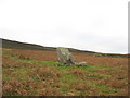
Neolithic and Bronze AgeSite Name: Hafodlas Cairn CircleCountry: Wales County: Gwynedd Type: Cairn
Map Ref: SH54056170
Latitude: 53.132418N Longitude: 4.182993W
Condition:
| 5 | Perfect |
| 4 | Almost Perfect |
| 3 | Reasonable but with some damage |
| 2 | Ruined but still recognisable as an ancient site |
| 1 | Pretty much destroyed, possibly visible as crop marks |
| 0 | No data. |
| -1 | Completely destroyed |
| 5 | Superb |
| 4 | Good |
| 3 | Ordinary |
| 2 | Not Good |
| 1 | Awful |
| 0 | No data. |
| 5 | Can be driven to, probably with disabled access |
| 4 | Short walk on a footpath |
| 3 | Requiring a bit more of a walk |
| 2 | A long walk |
| 1 | In the middle of nowhere, a nightmare to find |
| 0 | No data. |
| 5 | co-ordinates taken by GPS or official recorded co-ordinates |
| 4 | co-ordinates scaled from a detailed map |
| 3 | co-ordinates scaled from a bad map |
| 2 | co-ordinates of the nearest village |
| 1 | co-ordinates of the nearest town |
| 0 | no data |
Internal Links:
External Links:
")
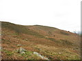
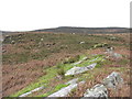
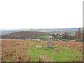
The heather-covered cairn is circular on plan and measures about 11m in diameter and up to 0.75m in height. A well defined kerb of large stones is visible around much of the perimeter and two larger upright stones stand within the cairn.
You may be viewing yesterday's version of this page. To see the most up to date information please register for a free account.
")
")
")
Do not use the above information on other web sites or publications without permission of the contributor.
Nearby Images from Geograph Britain and Ireland:
©2007(licence)
©2007(licence)
©2006(licence)
©2007(licence)
©2007(licence)
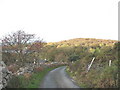
The above images may not be of the site on this page, they are loaded from Geograph.
Please Submit an Image of this site or go out and take one for us!
Click here to see more info for this site
Nearby sites
Key: Red: member's photo, Blue: 3rd party photo, Yellow: other image, Green: no photo - please go there and take one, Grey: site destroyed
Download sites to:
KML (Google Earth)
GPX (GPS waypoints)
CSV (Garmin/Navman)
CSV (Excel)
To unlock full downloads you need to sign up as a Contributory Member. Otherwise downloads are limited to 50 sites.
Turn off the page maps and other distractions
Nearby sites listing. In the following links * = Image available
656m E 79° Parc-y-Gleision Standing Stone* Standing Stone (Menhir) (SH54706180)
847m E 88° Parc Y Gleision Hut Circle Settlement* Ancient Village or Settlement (SH549617)
1.3km E 85° Pen-y-bwlch settlement Ancient Village or Settlement (SH55336177)
1.5km W 265° Pant Ifan Maenhir* Standing Stone (Menhir) (SH52506160)
1.8km WNW 290° Pant Afon Bach Maenhir* Standing Stone (Menhir) (SH52366236)
2.2km SE 138° Chwarel Fawr Stones* Rock Art (SH5549660004)
2.2km W 280° Cilgwythwch Maenhir* Standing Stone (Menhir) (SH51866217)
2.5km NE 36° Cae Corniog Enclosed Hut Group* Ancient Village or Settlement (SH55576368)
2.8km NNE 13° Pen Y Gaer (Llanddeiniolen)* Hillfort (SH54776440)
3.1km N 10° Glascoed Ancient Village* Ancient Village or Settlement (SH547647)
3.3km N 10° Glyn Arthur* Cairn (SH547649)
3.5km NNE 22° Ffynnon Cegin Arthur Holy Well or Sacred Spring (SH55486488)
3.7km NNE 12° Dinas Dinorwig* Hillfort (SH549653)
4.4km NE 45° Enclosed Hut Group SW of Cae'r Mynydd* Ancient Village or Settlement (SH57256469)
4.5km NE 36° Coed y Castell Enclosed Hut Circle Settlement* Ancient Village or Settlement (SH5681065230)
4.8km ESE 112° Parc Bach* Chambered Tomb (SH5846359778)
5.2km SW 227° Gaerwen Ancient Village or Settlement (SH501583)
5.6km W 276° Segontium* Stone Fort or Dun (SH4852262408)
5.8km W 273° St Helen's Well (Coed Helen) Holy Well or Sacred Spring (SH4823862224)
6.0km WNW 287° Modern Stone Circle (Caernarfon)* Modern Stone Circle etc (SH4835463629)
6.0km WNW 287° Modern Standing Stones (Caernarfon)* Modern Stone Circle etc (SH4833363592)
6.3km S 176° Craig Cwmbychan Cairn* Cairn (SH54335542)
6.4km NE 45° Ty'n Llidiard Hut Circle Settlement* Ancient Village or Settlement (SH5873066090)
6.6km N 360° Cader Elwa* Standing Stone (Menhir) (SH542683)
6.7km NE 47° Carnedd Moel Y Ci* Round Cairn (SH591661)
View more nearby sites and additional images


 We would like to know more about this location. Please feel free to add a brief description and any relevant information in your own language.
 Wir möchten mehr über diese Stätte erfahren. Bitte zögern Sie nicht, eine kurze Beschreibung und relevante Informationen in Deutsch hinzuzufügen.
 Nous aimerions en savoir encore un peu sur les lieux. S'il vous plaît n'hesitez pas à ajouter une courte description et tous les renseignements pertinents dans votre propre langue.
 Quisieramos informarnos un poco más de las lugares. No dude en añadir una breve descripción y otros datos relevantes en su propio idioma.