


<< Text Pages >> Caulside Burn Stone Setting - Stone Row / Alignment in Scotland in Dumfries and Galloway
Submitted by Anne T on Tuesday, 27 February 2018 Page Views: 1214
Neolithic and Bronze AgeSite Name: Caulside Burn Stone SettingCountry: Scotland County: Dumfries and Galloway Type: Stone Row / Alignment
Nearest Town: Gatehouse of Fleet / Carsluith Nearest Village: Anwoth
Map Ref: NX52915722
Latitude: 54.888016N Longitude: 4.294697W
Condition:
| 5 | Perfect |
| 4 | Almost Perfect |
| 3 | Reasonable but with some damage |
| 2 | Ruined but still recognisable as an ancient site |
| 1 | Pretty much destroyed, possibly visible as crop marks |
| 0 | No data. |
| -1 | Completely destroyed |
| 5 | Superb |
| 4 | Good |
| 3 | Ordinary |
| 2 | Not Good |
| 1 | Awful |
| 0 | No data. |
| 5 | Can be driven to, probably with disabled access |
| 4 | Short walk on a footpath |
| 3 | Requiring a bit more of a walk |
| 2 | A long walk |
| 1 | In the middle of nowhere, a nightmare to find |
| 0 | No data. |
| 5 | co-ordinates taken by GPS or official recorded co-ordinates |
| 4 | co-ordinates scaled from a detailed map |
| 3 | co-ordinates scaled from a bad map |
| 2 | co-ordinates of the nearest village |
| 1 | co-ordinates of the nearest town |
| 0 | no data |
Be the first person to rate this site - see the 'Contribute!' box in the right hand menu.
Internal Links:
External Links:
I have visited· I would like to visit
markj99 visited on 5th Nov 2018 - their rating: Access: 3 While visiting the Cauldside Burn Cairn North I looked for the two stones first using GPS, then by grid searching the area S of the cairn. This was difficult due to tussocks of heather and uneven ground. I found no substantial stones in a 30 yards by 30 yards area.
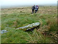
This Neolithic/Bronze Age stone setting is recorded as Canmore ID 63682 which tells us that 30ft south of a cairn, there are two standing stones, thought in 1895 to be part of a stone circle. One of the stones was upright whilst the other was tilted and sunk in peat.
In 1977, these stones were recorded as being 10.6m apart, the northern most stone 0.3m high, the other almost recumbent and sunk in half a metre of peat. The Canmore entry from 1977 continues that there is no evidence these were ever part of a stone circle, but do lie between the centres of two cairns at NX 5290 5725 and NX 5294 5714.
Note: Have you visited this site? Do you have any photographs or information to add?
You may be viewing yesterday's version of this page. To see the most up to date information please register for a free account.
Do not use the above information on other web sites or publications without permission of the contributor.
Nearby Images from Geograph Britain and Ireland:
©2009(licence)
©2011(licence)
©2013(licence)

©2014(licence)
©2014(licence)
The above images may not be of the site on this page, they are loaded from Geograph.
Please Submit an Image of this site or go out and take one for us!
Click here to see more info for this site
Nearby sites
Key: Red: member's photo, Blue: 3rd party photo, Yellow: other image, Green: no photo - please go there and take one, Grey: site destroyed
Download sites to:
KML (Google Earth)
GPX (GPS waypoints)
CSV (Garmin/Navman)
CSV (Excel)
To unlock full downloads you need to sign up as a Contributory Member. Otherwise downloads are limited to 50 sites.
Turn off the page maps and other distractions
Nearby sites listing. In the following links * = Image available
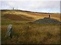
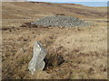
32m NNW 340° Caulside Burn Cairn North* Cairn (NX52905725)
85m SSE 158° Caulside Burn Cairn South* Cairn (NX52945714)
117m SSE 158° Cauldside Burn Stone Circle* Stone Circle (NX52955711)
171m NNW 338° Penny Stone (Cambret Moor)* Rock Art (NX52855738)
241m NNW 334° Cambret Moor Cairn* Cairn (NX52815744)
1.2km ESE 107° Cairnharrow Cup & Ring Marked Stone* Rock Art (NX54005684)
1.2km SSE 158° Cairnharrow Summit* Cairn (NX53335610)
1.7km SW 221° Claughreid* Stone Circle (NX5177356005)
1.9km NW 314° Glenquicken Stone* Standing Stone (Menhir) (NX51575858)
2.2km WNW 295° Glenquicken Circle* Stone Circle (NX50965821)
2.3km WNW 292° Glenquicken Cist* Cairn (NX50785815)
2.4km WNW 295° Glenquickan N Stone Circle (NX50795830)
2.5km SSW 203° Cairnholy 6* Rock Art (NX51855496)
2.7km SSW 206° Cairnholy 5* Rock Art (NX51615480)
2.9km WSW 240° Knock Gray Standing Stone* Standing Stone (Menhir) (NX5037055881)
2.9km SSW 206° Cairnholy 4* Rock Art (NX51555463)
3.1km SSW 203° Cairnholy 9* Rock Art (NX51615445)
3.2km WSW 253° Bagbie Four Poster* Stone Circle (NX49815638)
3.2km WSW 253° Bagbie stones* Standing Stones (NX4979956401)
3.2km SSW 195° Kirkdale Burn* Cairn (NX5198354134)
3.2km WSW 253° Bagbie cairn* Cairn (NX49795639)
3.2km WSW 253° Bagbie Wall Stone* Standing Stone (Menhir) (NX49795635)
3.3km WSW 250° Standing Stone of Bagbie* Standing Stone (Menhir) (NX4977456200)
3.4km SSW 197° Cairnholy 2* Chambered Cairn (NX5182054045)
3.4km ESE 109° Lady's Well (Anwoth) Holy Well or Sacred Spring (NX5608356025)
View more nearby sites and additional images


 We would like to know more about this location. Please feel free to add a brief description and any relevant information in your own language.
 Wir möchten mehr über diese Stätte erfahren. Bitte zögern Sie nicht, eine kurze Beschreibung und relevante Informationen in Deutsch hinzuzufügen.
 Nous aimerions en savoir encore un peu sur les lieux. S'il vous plaît n'hesitez pas à ajouter une courte description et tous les renseignements pertinents dans votre propre langue.
 Quisieramos informarnos un poco más de las lugares. No dude en añadir una breve descripción y otros datos relevantes en su propio idioma.