


<< Our Photo Pages >> White Hill South - Ring Cairn in England in Devon
Submitted by Anne T on Tuesday, 25 October 2016 Page Views: 1315
Neolithic and Bronze AgeSite Name: White Hill South Alternative Name: Grinsell Peter Tavy 1; Butler (map 32.22.1); Turner A8Country: England County: Devon Type: Ring Cairn
Nearest Town: Okehampton Nearest Village: Beardon
Map Ref: SX5294283680
Latitude: 50.634214N Longitude: 4.080833W
Condition:
| 5 | Perfect |
| 4 | Almost Perfect |
| 3 | Reasonable but with some damage |
| 2 | Ruined but still recognisable as an ancient site |
| 1 | Pretty much destroyed, possibly visible as crop marks |
| 0 | No data. |
| -1 | Completely destroyed |
| 5 | Superb |
| 4 | Good |
| 3 | Ordinary |
| 2 | Not Good |
| 1 | Awful |
| 0 | No data. |
| 5 | Can be driven to, probably with disabled access |
| 4 | Short walk on a footpath |
| 3 | Requiring a bit more of a walk |
| 2 | A long walk |
| 1 | In the middle of nowhere, a nightmare to find |
| 0 | No data. |
| 5 | co-ordinates taken by GPS or official recorded co-ordinates |
| 4 | co-ordinates scaled from a detailed map |
| 3 | co-ordinates scaled from a bad map |
| 2 | co-ordinates of the nearest village |
| 1 | co-ordinates of the nearest town |
| 0 | no data |
Be the first person to rate this site - see the 'Contribute!' box in the right hand menu.
Internal Links:
External Links:
")
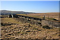
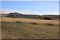
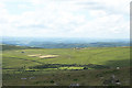
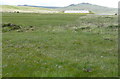
Information about the White Hill South Cairn Alignment Stone Ring Cairn Circle comes from the Prehistoric Dartmoor Walks (PDW) website. Their notes say this is a "ring cairn 460 metres south-west of White Hill summit, forming part of the White Hill round cairn cemetery. This monument includes a ring cairn situated on a gentle west-facing slope overlooking Willsworthy Army Camp. The earthwork appears as a raised internal platform measuring 15m in diameter surrounded by a circular bank 3.5m wide and 0.5m high. A shallow hollow in the centre of the internal area suggests robbing or partial early excavation. This cairn forms part of the White Hill round cairn cemetery .... cairn is part of an alignment of cairns (see photo)."
The PDW web page gives links to further information on Pastscape, Monument Number 440672, which adds that this is one of "a group of seven damaged Bronze Age cairns located on the west-facing slope of White Hill." For the cairn at this grid reference they give the description: "A: SX 52948368. A complete ring, 22.0m in external diameter, formed by a bank of earth and small stones 3.8m wide, 0.3m high externally and 0.15m high internally. The slightly raised interior is level except in the north west, where a pit has been dug 4.0m long, 2.0m wide and 0.5m deep; the upcast forms a mound 0.3m high on the west side. This and a small pit in the bank are almost certainly military works. There is no evidence of robbing and while the pit could have coincided with an original off-centre mound it seems more likely that this a simple ring cairn." The Pastscape record gives the grid references of all seven cairns in the group, which they describe as all being turf and heather covered.
The cairn is also recorded as MDV21078 (RING CAIRN in the Parish of Peter Tavy) on the Devon and Dartmoor HER, which describes this as the 'westernmost cairn of the group' and dates it from the Early Neolithic to the Late Bronze Age (4000BC to 701BC). It is also scheduled as Historic England List Entry No. 1011449 (Ring cairn 460m south-west of White Hill summit, forming part of the White Hill round cairn cemetery).
Note: Butler tells us there are six cairns in this group, grid references SX52948369, SX53008367, SX53058366, SX53098365, SX53148365 and SX53158366
You may be viewing yesterday's version of this page. To see the most up to date information please register for a free account.
Do not use the above information on other web sites or publications without permission of the contributor.
Nearby Images from Geograph Britain and Ireland:
©2010(licence)
©2010(licence)
©2010(licence)
©2011(licence)
©2011(licence)
The above images may not be of the site on this page, they are loaded from Geograph.
Please Submit an Image of this site or go out and take one for us!
Click here to see more info for this site
Nearby sites
Key: Red: member's photo, Blue: 3rd party photo, Yellow: other image, Green: no photo - please go there and take one, Grey: site destroyed
Download sites to:
KML (Google Earth)
GPX (GPS waypoints)
CSV (Garmin/Navman)
CSV (Excel)
To unlock full downloads you need to sign up as a Contributory Member. Otherwise downloads are limited to 50 sites.
Turn off the page maps and other distractions
Nearby sites listing. In the following links * = Image available
636m ENE 63° White Hill North Cairn Field Ring Cairn (SX53528395)
922m NE 55° White Hill North East* Cairn (SX5371384190)
1.1km SW 223° Ring of Bells* Ring Cairn (SX5214082873)
1.4km SE 124° Nattor Down 5 Cairn (SX54098286)
1.7km E 98° Ger Tor Cairn (SX54658338)
1.9km NE 49° Doe Tor* Cist (SX54388485)
2.9km SE 141° Standon Hill Cairn Cairn (SX5473781373)
3.4km NNE 33° Great Links Tor Cairn* Cairn (SX5491686496)
3.8km NNE 12° Great Nodden* Cist (SX5387487416)
4.0km NNE 18° Little Links Tor* Stone Row / Alignment (SX5428587463)
4.1km SW 225° Gibbett Hill Ring Cairn (SX49958084)
4.8km SE 129° Limsboro Cairn (SX5656780550)
4.8km S 169° Cudlipptown Down Cairn (SX5373278949)
5.1km NW 317° Burley Wood Hillfort Hillfort (SX49548754)
5.2km SSE 164° White Tor (Peter Tavy)* Ancient Village or Settlement (SX5424078673)
5.2km S 171° Cudliptown Down Enclosed Settlement* Ancient Village or Settlement (SX536785)
5.2km SSE 160° Cairns East of White Tor* Cairn (SX5459578695)
5.3km SSE 155° Langstone Moor stone row* Stone Row / Alignment (SX5502278851)
5.3km SSE 156° Langstone Moor row 2* Stone Row / Alignment (SX54957880)
5.3km SSE 160° East of White for cairn 2* Cairn (SX5459278664)
5.3km SSE 160° East of White Tor cairn 3* Cairn (SX5461278668)
5.3km SSE 159° East of White Tor Cairn 4* Cist (SX5469478690)
5.3km WSW 243° North Brentor Well* Holy Well or Sacred Spring (SX4813881440)
5.3km SSE 155° Langstone Moor 3 Stone Row / Alignment (SX55107880)
5.4km SSE 156° The Langstone* Standing Stone (Menhir) (SX55027873)
View more nearby sites and additional images


 We would like to know more about this location. Please feel free to add a brief description and any relevant information in your own language.
 Wir möchten mehr über diese Stätte erfahren. Bitte zögern Sie nicht, eine kurze Beschreibung und relevante Informationen in Deutsch hinzuzufügen.
 Nous aimerions en savoir encore un peu sur les lieux. S'il vous plaît n'hesitez pas à ajouter une courte description et tous les renseignements pertinents dans votre propre langue.
 Quisieramos informarnos un poco más de las lugares. No dude en añadir una breve descripción y otros datos relevantes en su propio idioma.