Featured: Friendly specialist tours to ancient, mystical and historical sites in the UK and beyond

Friendly specialist tours to ancient, mystical and historical sites in the UK and beyond

Random Image


Gurness

Stone Worlds: Narrative and Reflexivity in Landscape Archaeology

Stone Worlds: Narrative and Reflexivity in Landscape Archaeology

Who's Online

There are currently, 308 guests and 1 members online.

You are a guest. To join in, please register for free by clicking here

Sponsors

<< Our Photo Pages >> Nicholaston Long Cairn - Chambered Tomb in Wales in West Glamorgan

Submitted by vicky on Friday, 10 January 2003  Page Views: 9438

Neolithic and Bronze AgeSite Name: Nicholaston Long Cairn Alternative Name: Nicholaston
Country: Wales County: West Glamorgan Type: Chambered Tomb
Nearest Town: Swansea  Nearest Village: Penmaen
Map Ref: SS50768879  Landranger Map Number: 159
Latitude: 51.578160N  Longitude: 4.155171W
Condition:
5Perfect
4Almost Perfect
3Reasonable but with some damage
2Ruined but still recognisable as an ancient site
1Pretty much destroyed, possibly visible as crop marks
0No data.
-1Completely destroyed
3 Ambience:
5Superb
4Good
3Ordinary
2Not Good
1Awful
0No data.
3 Access:
5Can be driven to, probably with disabled access
4Short walk on a footpath
3Requiring a bit more of a walk
2A long walk
1In the middle of nowhere, a nightmare to find
0No data.
3 Accuracy:
5co-ordinates taken by GPS or official recorded co-ordinates
4co-ordinates scaled from a detailed map
3co-ordinates scaled from a bad map
2co-ordinates of the nearest village
1co-ordinates of the nearest town
0no data
5

Internal Links:
External Links:

I have visited· I would like to visit

PAB would like to visit

sem has visited here
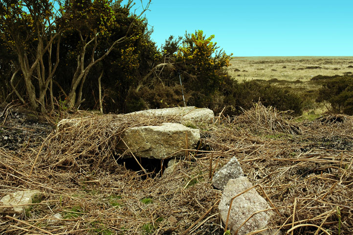
Nicholaston Long Cairn
Nicholaston Long Cairn submitted by sem : Unfortunately this tomb is on open heath used for grazing cattle, so the ground is covered in straw and cow***t. Very little remains to be seen. (Vote or comment on this photo)
Chambered Tomb in West Glamorgan

Have you visited this site? Please add a comment below.
You may be viewing yesterday's version of this page. To see the most up to date information please register for a free account.
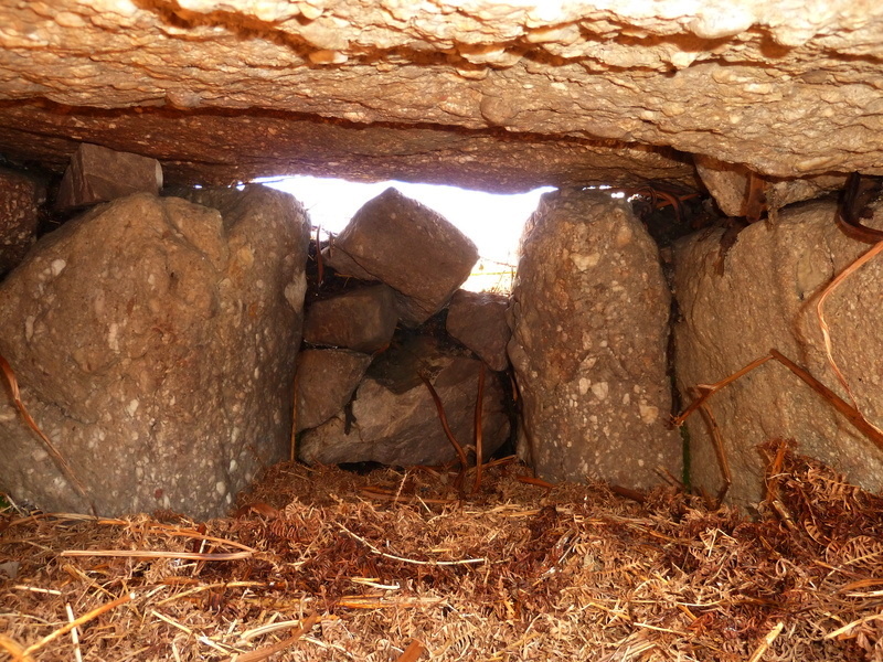
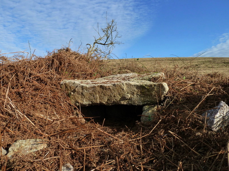
Nicholaston Long Cairn
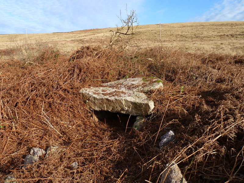
Nicholaston Long Cairn submitted by Bladup : Inside Nicholaston Chambered Long Cairn. (1 comment - Vote or comment on this photo)

Nicholaston Long Cairn
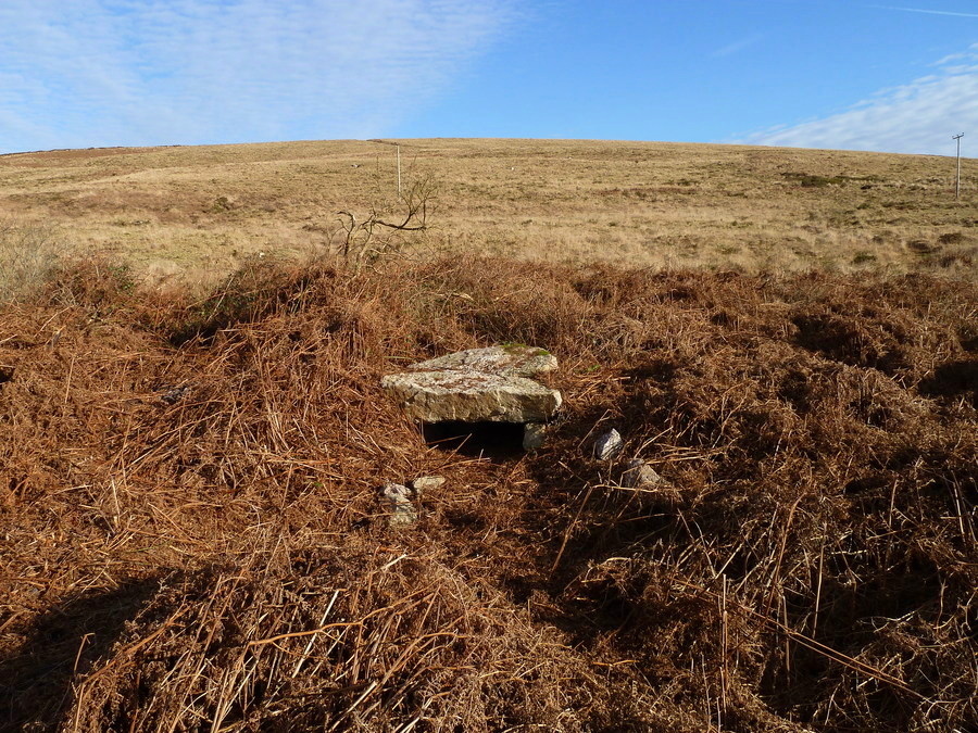
Nicholaston Long Cairn submitted by Bladup : Nicholaston Chambered Long Cairn looking north. (Vote or comment on this photo)

Nicholaston Long Cairn
Nicholaston Long Cairn submitted by Bladup : Nicholaston Chambered Long Cairn. (Vote or comment on this photo)

Nicholaston Long Cairn
Nicholaston Long Cairn submitted by Bladup : Nicholaston Chambered Long Cairn. It reminded me a lot of Tregeseal Chambered cairn (2 comments - Vote or comment on this photo)

Nicholaston Long Cairn
Nicholaston Long Cairn submitted by Bladup : Nicholaston Chambered Long Cairn. (Vote or comment on this photo)

Nicholaston Long Cairn
Nicholaston Long Cairn submitted by Bladup : Nicholaston Chambered Long Cairn looking west.

Nicholaston Long Cairn
Nicholaston Long Cairn submitted by Bladup : Nicholaston Chambered Long Cairn looking south.

Nicholaston Long Cairn
Nicholaston Long Cairn submitted by Bladup : Nicholaston Chambered Long Cairn looking east.

Nicholaston Long Cairn
Nicholaston Long Cairn submitted by Bladup : Nicholaston Chambered Long Cairn.

Do not use the above information on other web sites or publications without permission of the contributor.
Click here to see more info for this site

Nearby sites

Click here to view sites on an interactive OS map

Key: Red: member's photo, Blue: 3rd party photo, Yellow: other image, Green: no photo - please go there and take one, Grey: site destroyed

Download sites to:
KML (Google Earth)
GPX (GPS waypoints)
CSV (Garmin/Navman)
CSV (Excel)

To unlock full downloads you need to sign up as a Contributory Member. Otherwise downloads are limited to 50 sites.


Turn off the page maps and other distractions

Nearby sites listing. In the following links * = Image available
 234m NE 48° Nicholaston Hall Cairn Cairn (SS50948894)
 410m N 357° Talbot Road Cairn 1* Ring Cairn (SS50758920)
 420m N 357° Talbot Road Cairn 2 Ring Cairn (SS50758921)
 1.2km ENE 67° Cefn Bryn Burnt Mound 2 Misc. Earthwork (SS51888922)
 1.2km ENE 67° Cefn Bryn Burnt Mound Misc. Earthwork (SS51898922)
 1.2km ENE 68° Cefn Bryn Ring Cairn Ring Cairn (SS51918922)
 1.3km E 84° Cefn Bryn Cairn 1* Cairn (SS52068889)
 1.4km SE 125° Crawley Rocks Promontory Fort / Cliff Castle (SS51878796)
 1.4km E 85° Cefn Bryn Beacon 1 Cairn (SS52198886)
 1.5km E 86° Cefn Bryn Beacon 2 Cairn (SS52238886)
 1.6km NW 319° Holy Well (Cefn Bryn)* Holy Well or Sacred Spring (SS49769003)
 2.1km NW 312° Cefn Bryn Cairn 2* Ring Cairn (SS49269021)
 2.1km NW 314° Cefn Bryn Cairn 3* Ring Cairn (SS493903)
 2.4km NW 314° Maen Ceti cairn Ring Cairn (SS491905)
 2.4km NW 316° Maen Ceti* Chambered Tomb (SS49149055)
 2.5km NW 314° Cefn Bryn Great Cairn* Round Cairn (SS49029056)
 2.5km E 92° North Hills Lane Barrow Cemetary Barrow Cemetery (SS53248863)
 2.5km ESE 104° Penmaen Burrows* Chambered Tomb (SS53168812)
 2.5km ESE 114° Leather's Hole Cave or Rock Shelter (SS530877)
 2.6km NW 317° Cefn Bryn Cairn 1* Ring Cairn (SS4906690726)
 2.6km N 6° Pen-y-Crug Barrow* Round Barrow(s) (SS51099137)
 2.6km SW 216° Norton Camp (Swansea) Misc. Earthwork (SS4915486734)
 2.7km NW 304° Cefn Bryn SW Cairn* Ring Cairn (SS4854990395)
 3.0km WNW 291° Reynoldston Millennium Stone* Modern Stone Circle etc (SS47958997)
 3.0km ENE 68° Church Hill Earthwork* Misc. Earthwork (SS53628987)
View more nearby sites and additional images

<< Meini-Gwyn

Loch A Phobuill >>

Please add your thoughts on this site

Mesolithic Britain and Ireland: New Approaches

Mesolithic Britain and Ireland: New Approaches

Sponsors

Auto-Translation (Google)

Translate from English into:

"Nicholaston Long Cairn" | Login/Create an Account | 7 News and Comments
  
Go back to top of page    Comments are owned by the poster. We aren't responsible for their content.
Re: Nicholaston Long Cairn by Anonymous on Sunday, 22 February 2015
Visited a few weeks ago. Tricky to find and path was really muddy to walk along, but here's a guide, best as I can, for locating it!

Walking west to east along the footpath which runs roughly parallel to the main road, you reach this area where you then cross a small wooden bridge by the tree and turn right following the footpath sign for a few metres where you then turn left. There is then a turn on your left which takes you roughly behind the gorse and bridge and the stone chamber is tucked away about 20 metres away. It was almost completely covered when we visited but we managed to clear most of the bracken off! Lovely views to the sea from here too!
[ Reply to This ]

Re: Nicholaston Long Cairn by Gedv1 on Thursday, 30 December 2010
(User Info | Send a Message)
On scrubbing around in bushes as one does, I also found the black and white ringed finger post ( sans fingers! ) that once stood at the cross-roads at Nicholaston Cross, a piece of the living past and history of transport perhaps. It lay hidden beside the Corinthian style columns that once graced the outside of the 19C Oystermouth/Mumbles post office. The Gower Society were less than impressed with my find and never looked to their recovery. A short disinterested letter was their sole attention. I understand they have now disappeared again. Landfill no doubt!

When spring is in both the air and my step, I shall return to Gower. PAB, I can show you around Nicolaston. The church you refer to is on Penmaen Burrows nearby the burial chamber there. It is in poor but reasonable state, protected by the sand dunes packed around all its 4 - 5 ft walls, but drag your boot through the wind-blown interior sand to find the window mullions, plastered walls and floor.

But there is another church/chapel, that of St Nicholas lost in the woods above Nicholaston/Crawley Burrows. I wonder if the stairs I found were associated or not. I understand that it was the original church of the village. The new church above on the main Swansea - Oxwich ( South Gower ) road is 14C.

Knowing the way of the modern world, peradventure, when I return I will find a housing estate there!
[ Reply to This ]
    Re: Nicholaston Long Cairn by PAB on Thursday, 30 December 2010
    (User Info | Send a Message)
    Thanks Gedv1 - it would be great to explore the area when the weather picks up (and before the undergrowth wakes up I suppose?), so thanks very much for offering to act as guide.

    Please let me know when you are likely to be back in the area - our normal view of the Gower is of the west coast from across Carmarthen Bay, and it is high time we got to know it better!
    [ Reply to This ]

Re: Nicholaston Long Cairn by Andy B on Thursday, 30 December 2010
(User Info | Send a Message)
Indeed, we could use a description for this site, can you help. And welcome by the way.
[ Reply to This ]

Re: Nicholaston Long Cairn by PAB on Thursday, 30 December 2010
(User Info | Send a Message)
I wasn't clear Gedv1 what you weren't entirely agreeing with, so I had to follow the string back - and was fascinated by the details you had posted!

Firstly, congratulations on what you did to keep the tomb clear - and thanks for the local information. I will definitely be following your description over the next couple of months to see if I can locate the gems you have referred to.

On the 'lost church' you mention in your final paragraph, I have looked on the RCAHMW site, and I see that there is a mention on their map of St Mary's Chapel being lost to the sands - would this be the place you had in mind?
[ Reply to This ]

Re: Nicholaston Long Cairn by coldrum on Wednesday, 06 January 2010
(User Info | Send a Message)
Coflein site entry.

http://www.coflein.gov.uk/en/site/94594/details/CEFN+BRYN+BURIAL+CHAMBER%2C+NICHOLASTON/
[ Reply to This ]
    Re: Nicholaston Long Cairn by Gedv1 on Wednesday, 29 December 2010
    (User Info | Send a Message)
    A visit to the site will demonstrate that the monument is sinking, if you will, by the rising braken-dominated terrain, but drag your boot around a little to expose this chambered tomb. It isn't without interest. I cared for this tomb for many years by clearing it of its over-growth, until I moved away. Being on the underhill of Cefn Bryn it can be difficult to locate. Winter is best when the braken has died off, but the 'going' is sticky underfoot hereabouts.

    Parallel, to this, two thirds of a mile away easterly, unrecorded, is a fallen standing stone, 75 feet N.N.W. of the cottage at the bottom of the Bryn ( up the little dirt track lane opposite left, north-side of the main road of the car park at Penmaen ).

    Also interest here is Penmaen spring, a brick chambered tank with arched/dome roof. It is of considerable age being the historic water supply of the village. It was covered over early 20C. It is visible from the western end of Penmaen Loop road, and is due north, opposite Penmaen car-park. Just cross the road from the car park and follow the stream up hill. I understand that it was a sacred rising ( prior to the brick encasement ) as a number of items, possibly votive, have been recovered in the locality.

    If you enjoy scratching around, there are 19C. midden-heaps directly behind the nursing home at the top of the loop road at Penmaen. The nursing home is an old work-house. There are 19C midden heaps also in and around the spring at the fork in the road on the lane leading north from Nicholaston Cross, as well as on the underhill behind the houses and PYO field right at said fork from up from Nicholaston cross, behind a house called 'The Beacons'. Both sites have yielded good quality glass bottles and glazed clay bottles.

    Note also the rare Gower long-house on the path leading down to Penmaen burrows. Discover here on the burrows also, pillow mounds and abandoned 12C church near Penmaen chambered tomb.

    Likewise there is a lost church in the sand at the bottom of the path in the woods above Nicholaston Burrows. I once found a flight of steps here in the brambles under the sand. The steps are to the right as a path turns left beside a tree lined bank leading up onto the cliffs and Little Tor. I can't say if the steps are of any antiquity, and I suppose they are lost again.

    There is a pair of fine brick lime kilns at the very top of Nicholaston woods, below a craggy path. Go through the gate at the southern end of Nicholaston Cross lane and straight on beside the farm field, passed the quarry and then drop down left over a short cliff into the woods. Do not descend into the woods via the steps after the gate. A work plateau lies before them and beyond that a drop into the woods. They are very difficult to find. It took me many years to do so, but are very worth the investigation. Superb if you are also into industrial heritage.
    [ Reply to This ]

Your Name: Anonymous [ Register Now ]
Subject:


Add your comment or contribution to this page. Spam or offensive posts are deleted immediately, don't even bother

<<< What is five plus one as a number? (Please type the answer to this question in the little box on the left)
You can also embed videos and other things. For Youtube please copy and paste the 'embed code'.
For Google Street View please include Street View in the text.
Create a web link like this: <a href="https://www.megalithic.co.uk">This is a link</a>  

Allowed HTML is:
<p> <b> <i> <a> <img> <em> <br> <strong> <blockquote> <tt> <li> <ol> <ul> <object> <param> <embed> <iframe>

We would like to know more about this location. Please feel free to add a brief description and any relevant information in your own language.
Wir möchten mehr über diese Stätte erfahren. Bitte zögern Sie nicht, eine kurze Beschreibung und relevante Informationen in Deutsch hinzuzufügen.
Nous aimerions en savoir encore un peu sur les lieux. S'il vous plaît n'hesitez pas à ajouter une courte description et tous les renseignements pertinents dans votre propre langue.
Quisieramos informarnos un poco más de las lugares. No dude en añadir una breve descripción y otros datos relevantes en su propio idioma.