


<< Text Pages >> Tarbolton Tumulus - Cairn in Scotland in South Ayrshire
Submitted by AstroGeologist on Sunday, 19 May 2019 Page Views: 1004
Neolithic and Bronze AgeSite Name: Tarbolton Tumulus Alternative Name: King Coil's Grave, Coilsfield CairnCountry: Scotland
NOTE: This site is 0.3 km away from the location you searched for.
County: South Ayrshire Type: Cairn
Nearest Town: Prestwick Nearest Village: Tarbolton
Map Ref: NS4469926247
Latitude: 55.505235N Longitude: 4.460518W
Condition:
| 5 | Perfect |
| 4 | Almost Perfect |
| 3 | Reasonable but with some damage |
| 2 | Ruined but still recognisable as an ancient site |
| 1 | Pretty much destroyed, possibly visible as crop marks |
| 0 | No data. |
| -1 | Completely destroyed |
| 5 | Superb |
| 4 | Good |
| 3 | Ordinary |
| 2 | Not Good |
| 1 | Awful |
| 0 | No data. |
| 5 | Can be driven to, probably with disabled access |
| 4 | Short walk on a footpath |
| 3 | Requiring a bit more of a walk |
| 2 | A long walk |
| 1 | In the middle of nowhere, a nightmare to find |
| 0 | No data. |
| 5 | co-ordinates taken by GPS or official recorded co-ordinates |
| 4 | co-ordinates scaled from a detailed map |
| 3 | co-ordinates scaled from a bad map |
| 2 | co-ordinates of the nearest village |
| 1 | co-ordinates of the nearest town |
| 0 | no data |
Internal Links:
External Links:
Cairn in South Ayrshire
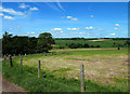
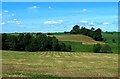
Located on the summit of a hill 90m above sea level, it is a few hundred metres from Water of Fail in Ayrshire.
Parish minister Rev. "David Ritchie" was present when the Tumulus was excavated in 1837. He tells how many human remains were discovered inside.
"The centre of the Tumulus once contained boulders of considerable size, at a depth of about 1.2m it had a circular flagstone (1m in diameter) beneath this was yellow clay and then another smaller flagstone, which covered an Urn filled with Human Ash.
Under clay surrounding the Urn, several small heaps of Human Bones were found under flat stones. In total 4 Urns were discovered in the Tumulus, the flower-pot shaped Urns were plain and they disintegrated on exposure to the air. The largest was 20cm in height and the same in diameter"
Notes from 20 years later in 1856 describe the Tarbolton Tumulus as a tree covered mound measuring 18m in diameter, that had two Whinstone Boulders on top of it - one of which had split in two.
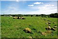
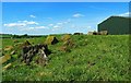
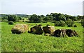
This once great Tumulus has now been reduced to an oval stony mound in a field behind a barn. The remains measure 14m N~S x 12m.
Photo's taken in 2014 show the remains of boulders along the SW arc, and the 2 large boulders that were once at the top of the Tumulus now lie at surface level next to a tree stump.
Known locally as King Coil's Grave, local legend has it the grave belongs to the warrior Coel/Coilus - who was a King of Northern Briton after the Romans had left. Remembered today in the nursery rhyme 'Old King Cole'
To read the 1837 quotes from : David Ritchie
And for more information : Canmore ID 42711
You may be viewing yesterday's version of this page. To see the most up to date information please register for a free account.
Do not use the above information on other web sites or publications without permission of the contributor.
Nearby Images from Geograph Britain and Ireland:
©2014(licence)
©2014(licence)
©2014(licence)
©2014(licence)
©2014(licence)
The above images may not be of the site on this page, they are loaded from Geograph.
Please Submit an Image of this site or go out and take one for us!
Click here to see more info for this site
Nearby sites
Key: Red: member's photo, Blue: 3rd party photo, Yellow: other image, Green: no photo - please go there and take one, Grey: site destroyed
Download sites to:
KML (Google Earth)
GPX (GPS waypoints)
CSV (Garmin/Navman)
CSV (Excel)
To unlock full downloads you need to sign up as a Contributory Member. Otherwise downloads are limited to 50 sites.
Turn off the page maps and other distractions
Nearby sites listing. In the following links * = Image available
11m SW 230° Coilsfield (Tarbolton) Rock Art (NS44692624)
1.9km WNW 292° Tarbolton Cist* Cist (NS4327)
4.2km NNE 13° Loch Lee Crannog* Crannog (NS45753027)
6.4km NNW 340° Witches Stane (Craigie) Natural Stone / Erratic / Other Natural Feature (NS42683231)
6.4km E 94° Ballochmyle* Rock Art (NS5111725565)
6.6km NNW 341° Craigie Dun Hillfort (NS42803254)
6.7km NNW 342° Craigie Broch Broch or Nuraghe (NS42793272)
7.0km NNW 337° Craigie Hill Fort Hillfort (NS42243276)
9.0km W 278° The Muckle Stane (Monkton)* Natural Stone / Erratic / Other Natural Feature (NS3578027790)
10.1km W 260° Bruce's Well (Prestwick)* Holy Well or Sacred Spring (NS3467624801)
10.7km NW 304° Harpercroft Hillfort Hillfort (NS36003252)
10.9km NW 305° Wardlaw Hill Fort Hillfort (NS35923276)
11.7km NW 307° Kemp Law* Stone Fort or Dun (NS35583364)
11.7km NW 313° Dun Donald Hillfort (NS36363451)
12.4km NE 41° Gallow Law (Hillend) Cairn (NS5313535382)
12.7km NNE 30° Molmont Stone Circle (NS514371)
13.4km NW 317° Drybridge* Standing Stone (Menhir) (NS35923644)
13.8km NW 318° Dundonald Cursus Cursus (NS35893690)
13.8km NW 318° Drybridge Neolithic Village Ancient Village or Settlement (NS3582336852)
14.4km SSW 211° Barbieston Farm cist* Cist (NS36751417)
14.5km WSW 237° Stonefield Park, Ayr* Standing Stone (Menhir) (NS32271869)
15.0km SW 228° Wallace's Stone (Blairstone Mains)* Early Christian Sculptured Stone (NS3321416579)
15.3km NW 320° Dreghorn Neolithic Village Ancient Village or Settlement (NS35183830)
16.1km NE 44° The Dagon Stone* Standing Stone (Menhir) (NS56333746)
16.6km NW 308° Shewalton Moor Ancient Village or Settlement (NS320370)
View more nearby sites and additional images


 We would like to know more about this location. Please feel free to add a brief description and any relevant information in your own language.
 Wir möchten mehr über diese Stätte erfahren. Bitte zögern Sie nicht, eine kurze Beschreibung und relevante Informationen in Deutsch hinzuzufügen.
 Nous aimerions en savoir encore un peu sur les lieux. S'il vous plaît n'hesitez pas à ajouter une courte description et tous les renseignements pertinents dans votre propre langue.
 Quisieramos informarnos un poco más de las lugares. No dude en añadir una breve descripción y otros datos relevantes en su propio idioma.