


<< Our Photo Pages >> Drannandow Chambered Cairn - Chambered Cairn in Scotland in Dumfries and Galloway
Submitted by vicky on Wednesday, 25 February 2004 Page Views: 7039
Neolithic and Bronze AgeSite Name: Drannandow Chambered CairnCountry: Scotland County: Dumfries and Galloway Type: Chambered Cairn
Nearest Town: Minnigaf / Newton Stewart Nearest Village: Cumlodden
Map Ref: NX40837135 Landranger Map Number: 77
Latitude: 55.011170N Longitude: 4.490674W
Condition:
| 5 | Perfect |
| 4 | Almost Perfect |
| 3 | Reasonable but with some damage |
| 2 | Ruined but still recognisable as an ancient site |
| 1 | Pretty much destroyed, possibly visible as crop marks |
| 0 | No data. |
| -1 | Completely destroyed |
| 5 | Superb |
| 4 | Good |
| 3 | Ordinary |
| 2 | Not Good |
| 1 | Awful |
| 0 | No data. |
| 5 | Can be driven to, probably with disabled access |
| 4 | Short walk on a footpath |
| 3 | Requiring a bit more of a walk |
| 2 | A long walk |
| 1 | In the middle of nowhere, a nightmare to find |
| 0 | No data. |
| 5 | co-ordinates taken by GPS or official recorded co-ordinates |
| 4 | co-ordinates scaled from a detailed map |
| 3 | co-ordinates scaled from a bad map |
| 2 | co-ordinates of the nearest village |
| 1 | co-ordinates of the nearest town |
| 0 | no data |
Be the first person to rate this site - see the 'Contribute!' box in the right hand menu.
Internal Links:
External Links:
")
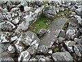
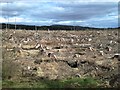
For more information see Canmore site no. 63578, which describes this cairn as being much robbed and disturbed and "measuring 23.0m EW by 15.0m. The chambers, one in the E end and two in either side, are well defined and each measures 2.2m by 1.0m."
You may be viewing yesterday's version of this page. To see the most up to date information please register for a free account.
")
")
")
Do not use the above information on other web sites or publications without permission of the contributor.
Nearby Images from Geograph Britain and Ireland:
©2022(licence)
©2010(licence)
©2010(licence)
©2007(licence)
©2016(licence)
The above images may not be of the site on this page, they are loaded from Geograph.
Please Submit an Image of this site or go out and take one for us!
Click here to see more info for this site
Nearby sites
Key: Red: member's photo, Blue: 3rd party photo, Yellow: other image, Green: no photo - please go there and take one, Grey: site destroyed
Download sites to:
KML (Google Earth)
GPX (GPS waypoints)
CSV (Garmin/Navman)
CSV (Excel)
To unlock full downloads you need to sign up as a Contributory Member. Otherwise downloads are limited to 50 sites.
Turn off the page maps and other distractions
Nearby sites listing. In the following links * = Image available
184m S 190° Rorie Gill * Cairn (NX40797117)
460m WNW 300° The Thieves* Standing Stones (NX4044071597)
490m SSW 195° Drannandow S* Cairn (NX40697088)
864m W 261° Drumfern Cairn* Round Cairn (NX39977124)
911m WSW 245° Drannandow Circle* Stone Circle (NX39997099)
960m WSW 244° Drumfern S* Cairn (NX39957096)
1.8km SSW 201° Barclye Rocking Stone* Natural Stone / Erratic / Other Natural Feature (NX4011169664)
2.4km S 184° Boreland* Chambered Cairn (NX40576900)
2.9km SSW 208° Drumwhirn Cairn* Cairn (NX39356884)
3.2km SW 214° Barclye Cairn* Cairn (NX38906873)
4.4km S 172° Wishing Pot (Minnigaff) Holy Well or Sacred Spring (NX4132666941)
4.5km ENE 63° The Laird's Well (Minnigaff) Holy Well or Sacred Spring (NX4492773263)
4.7km SE 145° Pot Well (Minnigaff) Holy Well or Sacred Spring (NX4340367419)
4.8km S 176° Minnigaff Old Church* Ancient Cross (NX4102666557)
5.1km SSW 194° Barnkirk Hill Hillfort (NX394664)
5.3km SSE 156° Gout Well of Larg (Minnigaff) Holy Well or Sacred Spring (NX4281766466)
5.6km SSE 157° Parliament Knowe Fort Hillfort (NX428661)
5.7km SSE 159° Kirroughtree House N* Cairn (NX42676596)
5.7km S 174° Charlie's Well (Minnigaff) Holy Well or Sacred Spring (NX4121565608)
5.8km S 170° Creebridge Cairn* Cairn (NX4168765595)
5.9km SSE 161° Kirroughtree House W* Cairn (NX42576566)
6.0km SSE 160° Kirroughtree House E* Cairn (NX42716568)
6.1km SSE 164° High Lessons* Cairn (NX42266540)
6.2km SSE 163° Low Lessons* Cairn (NX42426539)
6.6km NW 306° Clachaneasy Bridge* Cairn (NX35647542)
View more nearby sites and additional images


 We would like to know more about this location. Please feel free to add a brief description and any relevant information in your own language.
 Wir möchten mehr über diese Stätte erfahren. Bitte zögern Sie nicht, eine kurze Beschreibung und relevante Informationen in Deutsch hinzuzufügen.
 Nous aimerions en savoir encore un peu sur les lieux. S'il vous plaît n'hesitez pas à ajouter une courte description et tous les renseignements pertinents dans votre propre langue.
 Quisieramos informarnos un poco más de las lugares. No dude en añadir una breve descripción y otros datos relevantes en su propio idioma.