


<< Our Photo Pages >> Bodfeddan Inscribed Stone - Standing Stone (Menhir) in Wales in Anglesey
Submitted by TimPrevett on Tuesday, 24 September 2002 Page Views: 11418
Neolithic and Bronze AgeSite Name: Bodfeddan Inscribed StoneCountry: Wales County: Anglesey Type: Standing Stone (Menhir)
Nearest Town: Holyhead Nearest Village: Pencarnisiog
Map Ref: SH356745 Landranger Map Number: 114
Latitude: 53.241997N Longitude: 4.465093W
Condition:
| 5 | Perfect |
| 4 | Almost Perfect |
| 3 | Reasonable but with some damage |
| 2 | Ruined but still recognisable as an ancient site |
| 1 | Pretty much destroyed, possibly visible as crop marks |
| 0 | No data. |
| -1 | Completely destroyed |
| 5 | Superb |
| 4 | Good |
| 3 | Ordinary |
| 2 | Not Good |
| 1 | Awful |
| 0 | No data. |
| 5 | Can be driven to, probably with disabled access |
| 4 | Short walk on a footpath |
| 3 | Requiring a bit more of a walk |
| 2 | A long walk |
| 1 | In the middle of nowhere, a nightmare to find |
| 0 | No data. |
| 5 | co-ordinates taken by GPS or official recorded co-ordinates |
| 4 | co-ordinates scaled from a detailed map |
| 3 | co-ordinates scaled from a bad map |
| 2 | co-ordinates of the nearest village |
| 1 | co-ordinates of the nearest town |
| 0 | no data |
Internal Links:
External Links:
I have visited· I would like to visit
elad13 visited on 27th May 2023 - their rating: Cond: 4 Amb: 4 Access: 4
guile TimPrevett have visited here
")
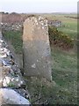
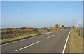
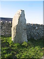
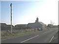
This stone is behind a wall, immediately opposite a white bungalow on east side of A4080. We parked on a very wide verge further down the road. The inscription is on the north side, and can be made out on the photo if not actually legible. The CADW guide to Gwynedd gives the inscription as CUNOGUSI HIC IACIT, meaning (The Stone) of Cunogussus. He lies here. It may have been a prehistoric monument, but is thought to be a 6th Cenutry AD monument, dated on the style and wording used.
You may be viewing yesterday's version of this page. To see the most up to date information please register for a free account.
")
")
")
Do not use the above information on other web sites or publications without permission of the contributor.
Nearby Images from Geograph Britain and Ireland:
©2006(licence)
©2008(licence)
©2008(licence)
©2008(licence)
©2008(licence)
The above images may not be of the site on this page, they are loaded from Geograph.
Please Submit an Image of this site or go out and take one for us!
Click here to see more info for this site
Nearby sites
Key: Red: member's photo, Blue: 3rd party photo, Yellow: other image, Green: no photo - please go there and take one, Grey: site destroyed
Download sites to:
KML (Google Earth)
GPX (GPS waypoints)
CSV (Garmin/Navman)
CSV (Excel)
To unlock full downloads you need to sign up as a Contributory Member. Otherwise downloads are limited to 50 sites.
Turn off the page maps and other distractions
Nearby sites listing. In the following links * = Image available
1.3km WSW 240° Ty Newydd (Llanfaelog)* Chambered Tomb (SH34437387)
2.5km NE 55° A55 Erratic* Natural Stone / Erratic / Other Natural Feature (SH3774475886)
4.4km SSW 207° Trecastell Farm (Llanfaelog) Sculptured Stone (SH33457065)
4.4km ESE 115° Din Dryfol* Chambered Tomb (SH3956572490)
4.5km SSW 209° Porth Trecastell* Hillfort (SH33257060)
4.6km SW 215° Mynydd Bach* Round Cairn (SH32847086)
4.6km SSW 214° Barclodiad-y-Gawres (Anglesey)* Passage Grave (SH32907074)
5.4km WNW 290° Llyn Cerrig Bach* Natural Stone / Erratic / Other Natural Feature (SH30607650)
5.9km E 84° Graiglas* Round Barrow(s) (SH415749)
5.9km SSE 150° St Cadwaladr (Llangadwaladr)* Early Christian Sculptured Stone (SH38376927)
6.0km E 82° Druid Farm* Standing Stones (SH416751)
6.4km N 351° Presaddfed* Chambered Tomb (SH34768089)
6.6km S 181° Trwyn Du* Cairn (SH352679)
6.7km E 95° St Ceinwen Holy Well* Holy Well or Sacred Spring (SH423737)
7.1km NNE 19° Maen Llechgynfarwy* Standing Stone (Menhir) (SH38108116)
7.4km SE 133° Malltraeth* Standing Stone (Menhir) (SH4085569306)
7.4km ESE 108° Hen Blas* Burial Chamber or Dolmen (SH42577197)
7.7km NNW 329° Shop Farm* Standing Stone (Menhir) (SH3180581223)
8.3km WNW 286° Bodior Standing Stone* Standing Stone (Menhir) (SH277770)
8.4km W 272° Borthwen Beach* Chambered Tomb (SH2714975151)
8.6km W 271° Borth Wen Stone Row / Alignment (SH27007500)
8.8km NNW 348° Tre-Gwehelydd* Standing Stone (Menhir) (SH34068318)
9.1km WNW 297° Ynys Leurad* Ancient Village or Settlement (SH2764978895)
9.2km N 2° New Church* Standing Stone (Menhir) (SH363837)
9.5km W 281° Cromlech in Rhoscolyn* Burial Chamber or Dolmen (SH2634376610)
View more nearby sites and additional images


 We would like to know more about this location. Please feel free to add a brief description and any relevant information in your own language.
 Wir möchten mehr über diese Stätte erfahren. Bitte zögern Sie nicht, eine kurze Beschreibung und relevante Informationen in Deutsch hinzuzufügen.
 Nous aimerions en savoir encore un peu sur les lieux. S'il vous plaît n'hesitez pas à ajouter une courte description et tous les renseignements pertinents dans votre propre langue.
 Quisieramos informarnos un poco más de las lugares. No dude en añadir una breve descripción y otros datos relevantes en su propio idioma.